Map of Cascade County - Cascade County is a county located in the U.S. state of Montana. Cascade County Map showing cities, highways, important places and water bodies. Get Where is Cascade County located in the map, major cities in Cascade county, population, areas, and places of interest.
Map of Cascade County, Montana
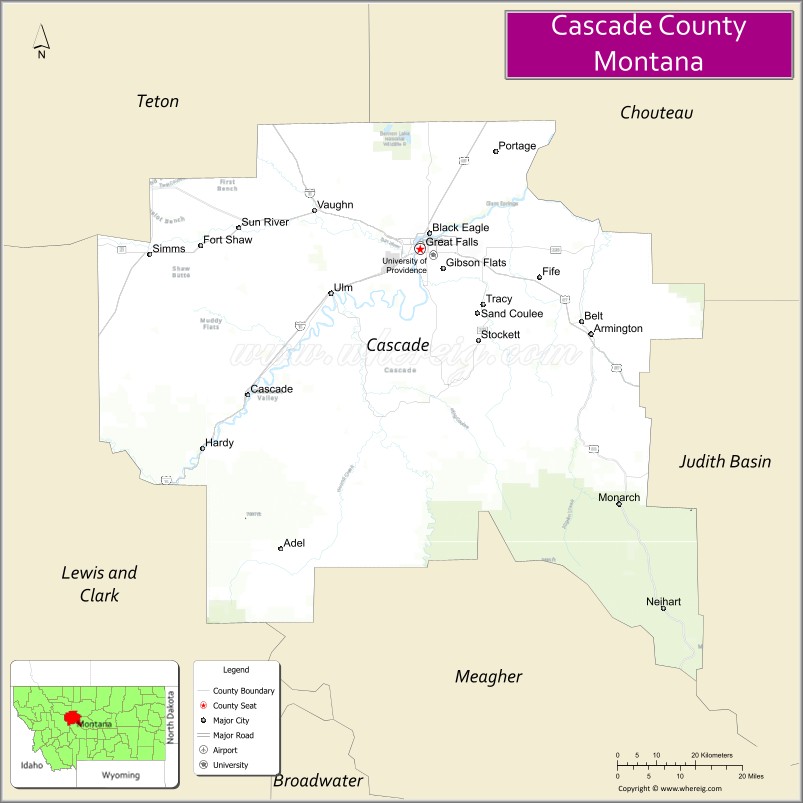
About Cascade County Map, Montana: The map showing the county boundary, county seat, major cities, highways, water bodies and neighbouring counties.
Other Montana Maps & Info
Map of Cascade County, Montana
Cascade County is a county located in the U.S. state of Montana. It's county seat is Great Falls. As per 2020 census, the population of Cascade County is 84511 people and population density is square miles. According to the United States Census Bureau, the county has a total area of 2,698 sq mi (6,988 km2). Cascade County was established on -4492.
Cascade County Facts
| Continent | North America |
| Country | United States |
| State | Montana |
| County Seat | Great Falls |
| Largest City/Town | Great Falls |
| Established | 1887 |
| Total Area | 2,711 sq mi (7,021 sq km) |
| Land Area | 2,698 sq mi (6,988 sq km) |
| Water Area | 13 sq mi (34 sq km) |
| Population | 84,414 (Census 2020) |
| Population Density | 31 people per sq mi |
| Time Zone | Mountain Time Zone (MST/MDT) |
| Major Highways | Interstate 15, U.S. Route 87, U.S. Route 89, Montana Highway 200 |
| Major Rivers | Missouri River, Sun River |
| Neighboring Counties | Teton County, Chouteau County, Judith Basin County, Meagher County, Lewis and Clark County, Powell County |
| Famous For | Great Falls, Missouri River waterfalls, Malmstrom Air Force Base, and Lewis and Clark history |
| Top Attractions | Giant Springs State Park, Lewis and Clark Interpretive Center, River's Edge Trail, and C.M. Russell Museum |
| Official Website | Official Website |
About Cascade County, Montana
Cascade County is located in central Montana in the western United States and was established in 1887. The county seat and largest city is Great Falls. The county is known for its scenic Missouri River waterfalls, military history, outdoor recreation, and its role as an important transportation and economic center in Montana.
Cities and Towns in Cascade County, Montana
| City/Town | Population (Census 2020) | Latitude & Longitude |
|---|---|---|
| Great Falls (county seat) | 60,442 | 47.5053°N, 111.3008°W |
| Belt | 510 | 47.3866°N, 110.9271°W |
| Cascade | 592 | 47.2816°N, 111.6875°W |
| Ulm (CDP) | 748 | 47.4635°N, 111.5107°W |
| Sun Prairie (CDP) | 1,936 | 47.5319°N, 111.2064°W |
| Sand Coulee | 212 | 47.3942°N, 111.1796°W |
Golf Courses in Cascade County, Montana
| Golf Course | Location | Latitude & Longitude |
|---|---|---|
| Anaconda Hills Golf Course | Great Falls | 47.4897°N, 111.3146°W |
| Eagle Falls Golf Club | Great Falls | 47.5155°N, 111.2739°W |
Major Roads and Highways in Cascade County, Montana
Major highways connect the county with regional cities and scenic Montana destinations.
- Interstate 15 - major north-south interstate linking Great Falls with Helena and Canada
- U.S. Route 87 - major route connecting Great Falls with Billings and Lewistown
- U.S. Route 89 - scenic highway leading toward Glacier National Park and central Montana
- Montana Highway 200 - regional east-west route crossing central Montana
What are the Neighboring Counties of Cascade County
- Teton County (northwest)
- Chouteau County (north)
- Judith Basin County (east)
- Meagher County (southeast)
- Lewis and Clark County (southwest)
- Powell County (west)
What are the top Attractions in Cascade County, Montana
The county offers a mix of historic, cultural, and outdoor recreation attractions.
- Giant Springs State Park - scenic park featuring one of the largest freshwater springs in the United States
- Lewis and Clark Interpretive Center - museum highlighting the Lewis and Clark Expedition through Montana
- C.M. Russell Museum - art museum dedicated to famed western artist Charles M. Russell
- River's Edge Trail - scenic recreational trail system along the Missouri River
- Great Falls of the Missouri River - historic waterfalls explored by Lewis and Clark
- Malmstrom Air Force Base Museum Area - military heritage connected to the U.S. Air Force presence
- First Peoples Buffalo Jump State Park - important Native American archaeological and cultural site
- Downtown Great Falls Historic District - historic architecture, shops, and cultural attractions
- Belt Creek Canyon - scenic canyon area popular for hiking and outdoor recreation
- Missouri River Fishing Areas - recreation destinations for fishing, boating, and wildlife viewing
Distance from Cascade County to Nearby Cities
The following distances are measured by road (driving).
- Great Falls to Helena (Lewis and Clark County), Montana - 91 mi (146 km)
- Great Falls to Billings (Yellowstone County), Montana - 220 mi (354 km)
- Great Falls to Bozeman (Gallatin County), Montana - 176 mi (283 km)
- Great Falls to Missoula (Missoula County), Montana - 165 mi (266 km)
- Great Falls to Havre (Hill County), Montana - 115 mi (185 km)
- Great Falls to Cascade (Cascade County), Montana - 29 mi (47 km)
- Great Falls to Belt (Cascade County), Montana - 18 mi (29 km)
- Great Falls to Lewistown (Fergus County), Montana - 126 mi (203 km)
- Great Falls to Kalispell (Flathead County), Montana - 203 mi (327 km)
- Great Falls to Butte (Silver Bow County), Montana - 140 mi (225 km)
- Great Falls to Glacier National Park (West Entrance) - 153 mi (246 km)
- Great Falls to Spokane (Spokane County), Washington - 356 mi (573 km)
- Great Falls to Calgary, Alberta - 289 mi (465 km)
FAQs about Cascade County
Cascade County is located in central Montana along the Missouri River.
Cascade County had a population of 84,414 according to the 2020 United States Census.
Cascade County is known for Great Falls, Missouri River waterfalls, Lewis and Clark history, and outdoor recreation.
The county is served by Interstate 15, U.S. Route 87, U.S. Route 89, and Montana Highway 200.
Yes, Cascade County includes golf facilities such as Anaconda Hills Golf Course and Eagle Falls Golf Club.
References
- QuickFacts - U.S. Census Bureau
- United States Census Bureau
- United States Geological Survey (USGS)
- National Geodetic Survey
- Official Website
- Beaverhead County Map
- Big Horn County Map
- Blaine County Map
- Broadwater County Map
- Carbon County Map
- Carter County Map
- Cascade County Map
- Chouteau County Map
- Custer County Map
- Daniels County Map
- Dawson County Map
- Deer Lodge County Map
- Fallon County Map
- Fergus County Map
- Flathead County Map
- Gallatin County Map
- Garfield County Map
- Glacier County Map
- Golden Valley County Map
- Granite County Map
- Hill County Map
- Jefferson County Map
- Judith Basin County Map
- Lake County Map
- Lewis and Clark County Map
- Liberty County Map
- Lincoln County Map
- McCone County Map
- Madison County Map
- Meagher County Map
- Mineral County Map
- Missoula County Map
- Musselshell County Map
- Park County Map
- Petroleum County Map
- Phillips County Map
- Pondera County Map
- Powder River County Map
- Powell County Map
- Prairie County Map
- Ravalli County Map
- Richland County Map
- Roosevelt County Map
- Rosebud County Map
- Sanders County Map
- Sheridan County Map
- Silver Bow County Map
- Stillwater County Map
- Sweet Grass County Map
- Teton County Map
- Toole County Map
- Treasure County Map
- Valley County Map
- Wheatland County Map
- Wibaux County Map
- Yellowstone County Map
- Alabama Counties
- Alaska boroughs
- Arizona Counties
- Arkansas Counties
- California County Map
- Colorado Counties
- Connecticut Counties
- Delaware Counties
- Florida County Map
- Georgia County Map
- Hawaii Counties
- Idaho Counties
- Illinois Counties
- Indiana Counties
- Iowa Counties
- Kansas Counties
- Kentucky Counties
- Louisiana Counties
- Maine Counties
- Maryland Counties
- Massachusetts Counties
- Michigan County Map
- Minnesota Counties
- Mississippi Counties
- Missouri Counties
- Montana Counties
- Nebraska Counties
- Nevada Counties
- New York Counties
- New Hampshire Counties
- New Jersey Counties
- New Mexico Counties
- North Carolina Counties
- North Dakota Counties
- Ohio County Map
- Oklahoma Counties
- Oregon Counties
- Pennsylvania Counties
- Rhode Island Counties
- South Carolina Counties
- South Dakota Counties
- Map of Tennessee
- Texas County Map
- Utah Counties
- Vermont Counties
- Virginia Counties
- Washington Counties
- West Virginia Counties
- Wisconsin Counties
- Wyoming Counties