Map of Musselshell County - Musselshell County is a county located in the U.S. state of Montana. Musselshell County Map showing cities, highways, important places and water bodies. Get Where is Musselshell County located in the map, major cities in Musselshell county, population, areas, and places of interest.
Map of Musselshell County, Montana
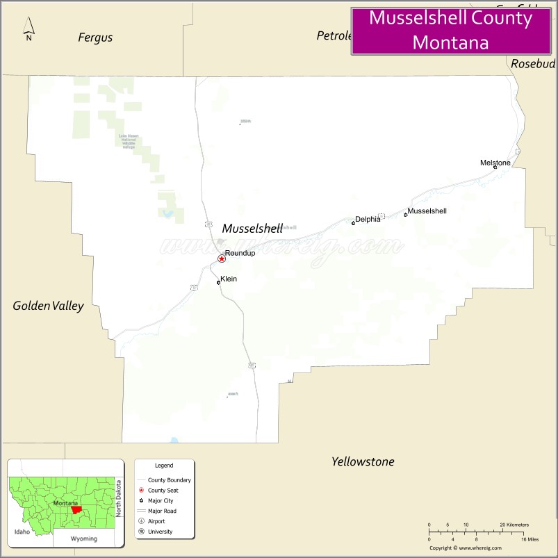
About Musselshell County Map, Montana: The map showing the county boundary, county seat, major cities, highways, water bodies and neighbouring counties.
Other Montana Maps & Info
Map of Musselshell County, Montana
Musselshell County is a county located in the U.S. state of Montana. It's county seat is Roundup. As per 2020 census, the population of Musselshell County is 4896 people and population density is square miles. According to the United States Census Bureau, the county has a total area of 1,867 sq mi (4,836 km2). Musselshell County was established on 4060.
Musselshell County Facts
| Continent | North America |
| Country | United States |
| State | Montana |
| County Seat | Roundup |
| Largest City/Town | Roundup |
| Established | 1911 |
| Total Area | 1,871 sq mi (4,846 sq km) |
| Land Area | 1,867 sq mi (4,837 sq km) |
| Water Area | 4 sq mi (9 sq km) |
| Population | 4,547 (Census 2020) |
| Population Density | 2.4 people per sq mi |
| Time Zone | Mountain Time Zone (MST/MDT) |
| Major Highways | U.S. Route 87, Montana Highway 12 |
| Major Rivers | Musselshell River |
| Neighboring Counties | Golden Valley County, Yellowstone County, Wheatland County, Petroleum County, Fergus County, Stillwater County |
| Famous For | Coal mining history, ranching, prairie landscapes, and Musselshell River recreation |
| Top Attractions | Musselshell River, Roundup Historic District, Bull Mountains, and coal mining heritage sites |
| Official Website | Official Website |
About Musselshell County, Montana
Musselshell County is located in central Montana in the western United States and was established in 1911. The county seat and largest town is Roundup. The county is known for its ranching economy, coal mining heritage, scenic prairie landscapes, and outdoor recreation along the Musselshell River valley.
Cities and Towns in Musselshell County, Montana
| City/Town | Population (Census 2020) | Latitude & Longitude |
|---|---|---|
| Roundup (county seat) | 1,748 | 46.4452°N, 108.5412°W |
| Melstone | 126 | 46.7930°N, 108.8529°W |
| Klein (CDP) | 163 | 46.3931°N, 108.6527°W |
| Lavina | 187 | 46.2910°N, 108.9385°W |
| Ryegate (Nearby Community) | 245 | 46.2975°N, 109.2487°W |
| Musselshell (Historic Community) | 52 | 46.5408°N, 108.0867°W |
Golf Courses in Musselshell County, Montana
| Golf Course | Location | Latitude & Longitude |
|---|---|---|
| Roundup Country Club | Roundup | 46.4506°N, 108.5484°W |
| Musselshell Valley Golf Recreation Area | Lavina | 46.2963°N, 108.9442°W |
Major Roads and Highways in Musselshell County, Montana
Major highways connect the county with central Montana ranching and mining communities.
- U.S. Route 87 - major north-south highway through central Montana
- Montana Highway 12 - regional route serving prairie and agricultural communities
What are the Neighboring Counties of Musselshell County
- Fergus County (north)
- Petroleum County (northwest)
- Wheatland County (west)
- Golden Valley County (southwest)
- Stillwater County (south)
- Yellowstone County (southeast)
What are the top Attractions in Musselshell County, Montana
The county offers a mix of prairie scenery, western heritage, and outdoor recreation.
- Musselshell River - scenic river corridor for fishing and wildlife viewing
- Roundup Historic District - downtown area featuring early 20th-century architecture and local history
- Bull Mountains - rugged hills and recreation areas popular for hunting and hiking
- Coal Mining Heritage Sites - historic attractions connected to Montana’s mining industry
- Roundup City Park and Recreation Areas - outdoor recreation and community events facilities
- Central Montana Prairie Scenic Drives - countryside routes with ranchland and open plains views
- Lavina Agricultural Heritage Sites - local farming and ranching history attractions
- Wildlife Observation Areas - habitats for deer, antelope, and migratory birds
- Musselshell Valley Recreation Areas - camping and outdoor activities along river valleys
- Historic Railroad Corridors - preserved transportation heritage sites in the region
Distance from Musselshell County to Nearby Cities
The following distances are measured by road (driving).
- Roundup to Billings (Yellowstone County), Montana - 52 mi (84 km)
- Roundup to Lewistown (Fergus County), Montana - 83 mi (134 km)
- Roundup to Harlowton (Wheatland County), Montana - 63 mi (101 km)
- Roundup to Bozeman (Gallatin County), Montana - 156 mi (251 km)
- Roundup to Helena (Lewis and Clark County), Montana - 178 mi (286 km)
- Roundup to Melstone (Musselshell County), Montana - 39 mi (63 km)
- Roundup to Lavina (Musselshell County), Montana - 24 mi (39 km)
- Roundup to Miles City (Custer County), Montana - 140 mi (225 km)
- Roundup to Great Falls (Cascade County), Montana - 184 mi (296 km)
- Roundup to Missoula (Missoula County), Montana - 333 mi (536 km)
- Roundup to Rapid City (Pennington County), South Dakota - 315 mi (507 km)
- Roundup to Denver (Denver County), Colorado - 613 mi (987 km)
- Roundup to Spokane (Spokane County), Washington - 557 mi (896 km)
FAQs about Musselshell County
Musselshell County is located in central Montana in the prairie and ranching region.
Musselshell County had a population of 4,547 according to the 2020 United States Census.
Musselshell County is known for coal mining history, ranching, prairie scenery, and the Musselshell River.
The county is served by U.S. Route 87 and Montana Highway 12.
Yes, Musselshell County includes golf facilities such as Roundup Country Club and valley recreation golf areas.
References
- QuickFacts - U.S. Census Bureau
- United States Census Bureau
- United States Geological Survey (USGS)
- National Geodetic Survey
- Official Website
- Beaverhead County Map
- Big Horn County Map
- Blaine County Map
- Broadwater County Map
- Carbon County Map
- Carter County Map
- Cascade County Map
- Chouteau County Map
- Custer County Map
- Daniels County Map
- Dawson County Map
- Deer Lodge County Map
- Fallon County Map
- Fergus County Map
- Flathead County Map
- Gallatin County Map
- Garfield County Map
- Glacier County Map
- Golden Valley County Map
- Granite County Map
- Hill County Map
- Jefferson County Map
- Judith Basin County Map
- Lake County Map
- Lewis and Clark County Map
- Liberty County Map
- Lincoln County Map
- McCone County Map
- Madison County Map
- Meagher County Map
- Mineral County Map
- Missoula County Map
- Musselshell County Map
- Park County Map
- Petroleum County Map
- Phillips County Map
- Pondera County Map
- Powder River County Map
- Powell County Map
- Prairie County Map
- Ravalli County Map
- Richland County Map
- Roosevelt County Map
- Rosebud County Map
- Sanders County Map
- Sheridan County Map
- Silver Bow County Map
- Stillwater County Map
- Sweet Grass County Map
- Teton County Map
- Toole County Map
- Treasure County Map
- Valley County Map
- Wheatland County Map
- Wibaux County Map
- Yellowstone County Map
- Alabama Counties
- Alaska boroughs
- Arizona Counties
- Arkansas Counties
- California County Map
- Colorado Counties
- Connecticut Counties
- Delaware Counties
- Florida County Map
- Georgia County Map
- Hawaii Counties
- Idaho Counties
- Illinois Counties
- Indiana Counties
- Iowa Counties
- Kansas Counties
- Kentucky Counties
- Louisiana Counties
- Maine Counties
- Maryland Counties
- Massachusetts Counties
- Michigan County Map
- Minnesota Counties
- Mississippi Counties
- Missouri Counties
- Montana Counties
- Nebraska Counties
- Nevada Counties
- New York Counties
- New Hampshire Counties
- New Jersey Counties
- New Mexico Counties
- North Carolina Counties
- North Dakota Counties
- Ohio County Map
- Oklahoma Counties
- Oregon Counties
- Pennsylvania Counties
- Rhode Island Counties
- South Carolina Counties
- South Dakota Counties
- Map of Tennessee
- Texas County Map
- Utah Counties
- Vermont Counties
- Virginia Counties
- Washington Counties
- West Virginia Counties
- Wisconsin Counties
- Wyoming Counties