Map of Chouteau County - Chouteau County is a county located in the U.S. state of Montana. Chouteau County Map showing cities, highways, important places and water bodies. Get Where is Chouteau County located in the map, major cities in Chouteau county, population, areas, and places of interest.
Map of Chouteau County, Montana
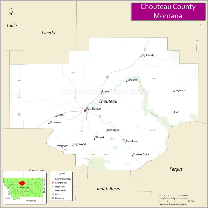
About Chouteau County Map, Montana: The map showing the county boundary, county seat, major cities, highways, water bodies and neighbouring counties.
Other Montana Maps & Info
Map of Chouteau County, Montana
Chouteau County is a county located in the U.S. state of Montana. It's county seat is Fort Benton. As per 2020 census, the population of Chouteau County is 5916 people and population density is square miles. According to the United States Census Bureau, the county has a total area of 3,973 sq mi (10,290 km2). Chouteau County was established on -12749.
Chouteau County Facts
| Continent | North America |
| Country | United States |
| State | Montana |
| County Seat | Fort Benton |
| Largest City/Town | Fort Benton |
| Established | 1865 |
| Total Area | 3,997 sq mi (10,352 sq km) |
| Land Area | 3,972 sq mi (10,287 sq km) |
| Water Area | 25 sq mi (65 sq km) |
| Population | 5,970 (Census 2020) |
| Population Density | 1.5 people per sq mi |
| Time Zone | Mountain Time Zone (MST/MDT) |
| Major Highways | U.S. Route 87, Montana Highway 80, Montana Highway 236 |
| Major Rivers | Missouri River, Marias River |
| Neighboring Counties | Hill County, Liberty County, Blaine County, Fergus County, Judith Basin County, Cascade County, Teton County |
| Famous For | Fort Benton history, Missouri River trade routes, and prairie landscapes |
| Top Attractions | Fort Benton Historic District, Missouri Breaks, Upper Missouri River National Monument, and the Museum of the Northern Great Plains |
| Official Website | Official Website |
About Chouteau County, Montana
Chouteau County is located in north-central Montana in the western United States and was established in 1865. The county seat and largest town is Fort Benton. The county is known for its rich frontier history, Missouri River heritage, wheat farming, and scenic prairie landscapes that played an important role during Montana’s early settlement period.
Cities and Towns in Chouteau County, Montana
| City/Town | Population (Census 2020) | Latitude & Longitude |
|---|---|---|
| Fort Benton (county seat) | 1,594 | 47.8197°N, 110.6677°W |
| Big Sandy | 510 | 48.1786°N, 110.1135°W |
| Geraldine | 261 | 47.6011°N, 110.2669°W |
| Highwood (CDP) | 141 | 47.5745°N, 110.7855°W |
| Carter (CDP) | 58 | 47.7591°N, 110.9388°W |
| Loma (CDP) | 72 | 47.9446°N, 110.4892°W |
Golf Courses in Chouteau County, Montana
| Golf Course | Location | Latitude & Longitude |
|---|---|---|
| Signal Point Golf Club | Fort Benton | 47.8246°N, 110.6758°W |
| Big Sandy Golf Recreation Area | Big Sandy | 48.1827°N, 110.1201°W |
Major Roads and Highways in Chouteau County, Montana
Major highways connect the county with central Montana communities and prairie regions.
- U.S. Route 87 - major north-south highway linking Fort Benton with Great Falls and Havre
- Montana Highway 80 - scenic route through farming and ranching communities
- Montana Highway 236 - regional road serving rural prairie and Missouri River areas
What are the Neighboring Counties of Chouteau County
- Hill County (north)
- Liberty County (northwest)
- Blaine County (east)
- Fergus County (southeast)
- Judith Basin County (south)
- Cascade County (southwest)
- Teton County (west)
What are the top Attractions in Chouteau County, Montana
The county offers a mix of historic landmarks, prairie scenery, and outdoor recreation.
- Fort Benton Historic District - preserved frontier river town known as the “Birthplace of Montana”
- Upper Missouri River Breaks National Monument - dramatic river canyon landscapes and wildlife habitats
- Museum of the Northern Great Plains - museum featuring regional history, agriculture, and pioneer exhibits
- Missouri River Recreation Areas - boating, fishing, and wildlife viewing destinations
- Fort Benton Riverwalk - scenic riverside walking trail through historic downtown
- Old Fort Benton Bridge - historic steel bridge crossing the Missouri River
- Big Sandy Community Museum - local history exhibits focused on prairie life and farming
- Highwood Mountains Scenic Drives - countryside routes with rolling hills and mountain views
- Marias River Natural Areas - outdoor recreation and birdwatching opportunities
- Chouteau County Prairie Landscapes - expansive wheat fields and ranching scenery typical of Montana plains
Distance from Chouteau County to Nearby Cities
The following distances are measured by road (driving).
- Fort Benton to Great Falls (Cascade County), Montana - 41 mi (66 km)
- Fort Benton to Havre (Hill County), Montana - 78 mi (126 km)
- Fort Benton to Lewistown (Fergus County), Montana - 121 mi (195 km)
- Fort Benton to Helena (Lewis and Clark County), Montana - 132 mi (212 km)
- Fort Benton to Big Sandy (Chouteau County), Montana - 42 mi (68 km)
- Fort Benton to Geraldine (Chouteau County), Montana - 38 mi (61 km)
- Fort Benton to Billings (Yellowstone County), Montana - 238 mi (383 km)
- Fort Benton to Bozeman (Gallatin County), Montana - 205 mi (330 km)
- Fort Benton to Missoula (Missoula County), Montana - 231 mi (372 km)
- Fort Benton to Glasgow (Valley County), Montana - 189 mi (304 km)
- Fort Benton to Kalispell (Flathead County), Montana - 227 mi (365 km)
- Fort Benton to Calgary, Alberta - 358 mi (576 km)
- Fort Benton to Spokane (Spokane County), Washington - 468 mi (753 km)
FAQs about Chouteau County
Chouteau County is located in north-central Montana along the Missouri River.
Chouteau County had a population of 5,970 according to the 2020 United States Census.
Chouteau County is known for Fort Benton history, Missouri River trade routes, and scenic prairie landscapes.
The county is served by U.S. Route 87, Montana Highway 80, and Montana Highway 236.
Yes, Chouteau County includes golf facilities such as Signal Point Golf Club and recreation golf areas in Big Sandy.
References
- QuickFacts - U.S. Census Bureau
- United States Census Bureau
- United States Geological Survey (USGS)
- National Geodetic Survey
- Official Website
- Beaverhead County Map
- Big Horn County Map
- Blaine County Map
- Broadwater County Map
- Carbon County Map
- Carter County Map
- Cascade County Map
- Chouteau County Map
- Custer County Map
- Daniels County Map
- Dawson County Map
- Deer Lodge County Map
- Fallon County Map
- Fergus County Map
- Flathead County Map
- Gallatin County Map
- Garfield County Map
- Glacier County Map
- Golden Valley County Map
- Granite County Map
- Hill County Map
- Jefferson County Map
- Judith Basin County Map
- Lake County Map
- Lewis and Clark County Map
- Liberty County Map
- Lincoln County Map
- McCone County Map
- Madison County Map
- Meagher County Map
- Mineral County Map
- Missoula County Map
- Musselshell County Map
- Park County Map
- Petroleum County Map
- Phillips County Map
- Pondera County Map
- Powder River County Map
- Powell County Map
- Prairie County Map
- Ravalli County Map
- Richland County Map
- Roosevelt County Map
- Rosebud County Map
- Sanders County Map
- Sheridan County Map
- Silver Bow County Map
- Stillwater County Map
- Sweet Grass County Map
- Teton County Map
- Toole County Map
- Treasure County Map
- Valley County Map
- Wheatland County Map
- Wibaux County Map
- Yellowstone County Map
- Alabama Counties
- Alaska boroughs
- Arizona Counties
- Arkansas Counties
- California County Map
- Colorado Counties
- Connecticut Counties
- Delaware Counties
- Florida County Map
- Georgia County Map
- Hawaii Counties
- Idaho Counties
- Illinois Counties
- Indiana Counties
- Iowa Counties
- Kansas Counties
- Kentucky Counties
- Louisiana Counties
- Maine Counties
- Maryland Counties
- Massachusetts Counties
- Michigan County Map
- Minnesota Counties
- Mississippi Counties
- Missouri Counties
- Montana Counties
- Nebraska Counties
- Nevada Counties
- New York Counties
- New Hampshire Counties
- New Jersey Counties
- New Mexico Counties
- North Carolina Counties
- North Dakota Counties
- Ohio County Map
- Oklahoma Counties
- Oregon Counties
- Pennsylvania Counties
- Rhode Island Counties
- South Carolina Counties
- South Dakota Counties
- Map of Tennessee
- Texas County Map
- Utah Counties
- Vermont Counties
- Virginia Counties
- Washington Counties
- West Virginia Counties
- Wisconsin Counties
- Wyoming Counties