Map of Lewis and Clark County - Lewis and Clark County is a county located in the U.S. state of Montana. Lewis and Clark County Map showing cities, highways, important places and water bodies. Get Where is Lewis and Clark County located in the map, major cities in Lewis and Clark county, population, areas, and places of interest.
Map of Lewis and Clark County, Montana
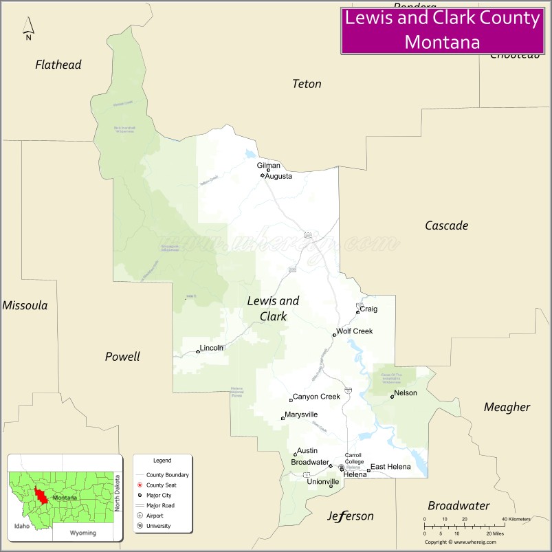
About Lewis and Clark County Map, Montana: The map showing the county boundary, county seat, major cities, highways, water bodies and neighbouring counties.
Other Montana Maps & Info
Map of Lewis and Clark County, Montana
Lewis and Clark County is a county located in the U.S. state of Montana. It's county seat is Helena. As per 2020 census, the population of Lewis and Clark County is 72223 people and population density is square miles. According to the United States Census Bureau, the county has a total area of 3,461 sq mi (8,964 km2). Lewis and Clark County was established on -12749.
Lewis and Clark County Facts
| Continent | North America |
| Country | United States |
| State | Montana |
| County Seat | Helena |
| Largest City/Town | Helena |
| Established | 1865 |
| Total Area | 3,498 sq mi (9,060 sq km) |
| Land Area | 3,459 sq mi (8,959 sq km) |
| Water Area | 39 sq mi (101 sq km) |
| Population | 70,973 (Census 2020) |
| Population Density | 20.5 people per sq mi |
| Time Zone | Mountain Time Zone (MST/MDT) |
| Major Highways | Interstate 15, U.S. Route 12, Montana Highway 200 |
| Major Rivers | Missouri River, Dearborn River |
| Neighboring Counties | Teton County, Powell County, Jefferson County, Broadwater County, Meagher County, Cascade County |
| Famous For | Montana state capital, historic gold rush heritage, and mountain recreation |
| Top Attractions | Montana State Capitol, Gates of the Mountains, Helena Historic District, and Cathedral of St. Helena |
| Official Website | Official Website |
About Lewis and Clark County, Montana
Lewis and Clark County is located in west-central Montana in the western United States and was established in 1865. The county seat and largest city is Helena, the capital of Montana. The county is known for its rich gold rush history, government institutions, scenic mountain landscapes, and abundant outdoor recreation opportunities.
Cities and Towns in Lewis and Clark County, Montana
| City/Town | Population (Census 2020) | Latitude & Longitude |
|---|---|---|
| Helena (county seat) | 32,091 | 46.5884°N, 112.0245°W |
| East Helena | 2,292 | 46.5891°N, 111.9150°W |
| Lincoln | 1,084 | 46.9549°N, 112.6817°W |
| Augusta | 309 | 47.4902°N, 112.3920°W |
| Canyon Creek (CDP) | 281 | 46.7581°N, 112.3117°W |
| Wolf Creek (CDP) | 189 | 47.0149°N, 112.0881°W |
Golf Courses in Lewis and Clark County, Montana
| Golf Course | Location | Latitude & Longitude |
|---|---|---|
| Bill Roberts Golf Course | Helena | 46.6062°N, 112.0348°W |
| Green Meadow Country Club | Helena | 46.6253°N, 112.0204°W |
Major Roads and Highways in Lewis and Clark County, Montana
Major highways connect the county with central Montana cities and mountain recreation destinations.
- Interstate 15 - major north-south interstate linking Helena with Great Falls and Butte
- U.S. Route 12 - important east-west highway through Helena and mountain valleys
- Montana Highway 200 - scenic route crossing central and western Montana
What are the Neighboring Counties of Lewis and Clark County
- Teton County (north)
- Cascade County (northeast)
- Meagher County (east)
- Broadwater County (southeast)
- Jefferson County (south)
- Powell County (west)
What are the top Attractions in Lewis and Clark County, Montana
The county offers a mix of historic landmarks, government institutions, and scenic outdoor recreation.
- Montana State Capitol - historic state capitol building with classic architecture and government exhibits
- Gates of the Mountains - scenic Missouri River canyon explored by Lewis and Clark
- Helena Historic District - preserved downtown area with Victorian-era buildings and cultural attractions
- Cathedral of St. Helena - iconic Gothic-style cathedral in downtown Helena
- Mount Helena City Park - hiking trails and panoramic views overlooking the capital city
- Holter Museum of Art - regional museum featuring contemporary and local art exhibits
- Lewis and Clark National Forest nearby region - camping, hiking, and mountain recreation
- Great Divide Ski Area - winter recreation destination near Helena
- Spring Meadow Lake State Park - swimming, fishing, and recreation area close to the city
- Last Chance Gulch - historic shopping and entertainment district in Helena
Distance from Lewis and Clark County to Nearby Cities
The following distances are measured by road (driving).
- Helena to Great Falls (Cascade County), Montana - 91 mi (146 km)
- Helena to Butte (Silver Bow County), Montana - 67 mi (108 km)
- Helena to Bozeman (Gallatin County), Montana - 97 mi (156 km)
- Helena to Missoula (Missoula County), Montana - 112 mi (180 km)
- Helena to Kalispell (Flathead County), Montana - 221 mi (356 km)
- Helena to East Helena (Lewis and Clark County), Montana - 6 mi (10 km)
- Helena to Lincoln (Lewis and Clark County), Montana - 57 mi (92 km)
- Helena to Billings (Yellowstone County), Montana - 237 mi (381 km)
- Helena to Spokane (Spokane County), Washington - 347 mi (558 km)
- Helena to Salt Lake City (Salt Lake County), Utah - 470 mi (756 km)
- Helena to Calgary, Alberta - 358 mi (576 km)
- Helena to Seattle (King County), Washington - 593 mi (954 km)
- Helena to Denver (Denver County), Colorado - 698 mi (1,123 km)
FAQs about Lewis and Clark County
Lewis and Clark County is located in west-central Montana and includes the state capital city of Helena.
Lewis and Clark County had a population of 70,973 according to the 2020 United States Census.
Lewis and Clark County is known for Helena, Montana’s state government, historic gold rush heritage, and mountain recreation.
The county is served by Interstate 15, U.S. Route 12, and Montana Highway 200.
Yes, Lewis and Clark County includes golf facilities such as Bill Roberts Golf Course and Green Meadow Country Club.
References
- QuickFacts - U.S. Census Bureau
- United States Census Bureau
- United States Geological Survey (USGS)
- National Geodetic Survey
- Official Website
- Beaverhead County Map
- Big Horn County Map
- Blaine County Map
- Broadwater County Map
- Carbon County Map
- Carter County Map
- Cascade County Map
- Chouteau County Map
- Custer County Map
- Daniels County Map
- Dawson County Map
- Deer Lodge County Map
- Fallon County Map
- Fergus County Map
- Flathead County Map
- Gallatin County Map
- Garfield County Map
- Glacier County Map
- Golden Valley County Map
- Granite County Map
- Hill County Map
- Jefferson County Map
- Judith Basin County Map
- Lake County Map
- Lewis and Clark County Map
- Liberty County Map
- Lincoln County Map
- McCone County Map
- Madison County Map
- Meagher County Map
- Mineral County Map
- Missoula County Map
- Musselshell County Map
- Park County Map
- Petroleum County Map
- Phillips County Map
- Pondera County Map
- Powder River County Map
- Powell County Map
- Prairie County Map
- Ravalli County Map
- Richland County Map
- Roosevelt County Map
- Rosebud County Map
- Sanders County Map
- Sheridan County Map
- Silver Bow County Map
- Stillwater County Map
- Sweet Grass County Map
- Teton County Map
- Toole County Map
- Treasure County Map
- Valley County Map
- Wheatland County Map
- Wibaux County Map
- Yellowstone County Map
- Alabama Counties
- Alaska boroughs
- Arizona Counties
- Arkansas Counties
- California County Map
- Colorado Counties
- Connecticut Counties
- Delaware Counties
- Florida County Map
- Georgia County Map
- Hawaii Counties
- Idaho Counties
- Illinois Counties
- Indiana Counties
- Iowa Counties
- Kansas Counties
- Kentucky Counties
- Louisiana Counties
- Maine Counties
- Maryland Counties
- Massachusetts Counties
- Michigan County Map
- Minnesota Counties
- Mississippi Counties
- Missouri Counties
- Montana Counties
- Nebraska Counties
- Nevada Counties
- New York Counties
- New Hampshire Counties
- New Jersey Counties
- New Mexico Counties
- North Carolina Counties
- North Dakota Counties
- Ohio County Map
- Oklahoma Counties
- Oregon Counties
- Pennsylvania Counties
- Rhode Island Counties
- South Carolina Counties
- South Dakota Counties
- Map of Tennessee
- Texas County Map
- Utah Counties
- Vermont Counties
- Virginia Counties
- Washington Counties
- West Virginia Counties
- Wisconsin Counties
- Wyoming Counties