Map of Fallon County - Fallon County is a county located in the U.S. state of Montana. Fallon County Map showing cities, highways, important places and water bodies. Get Where is Fallon County located in the map, major cities in Fallon county, population, areas, and places of interest.
Map of Fallon County, Montana
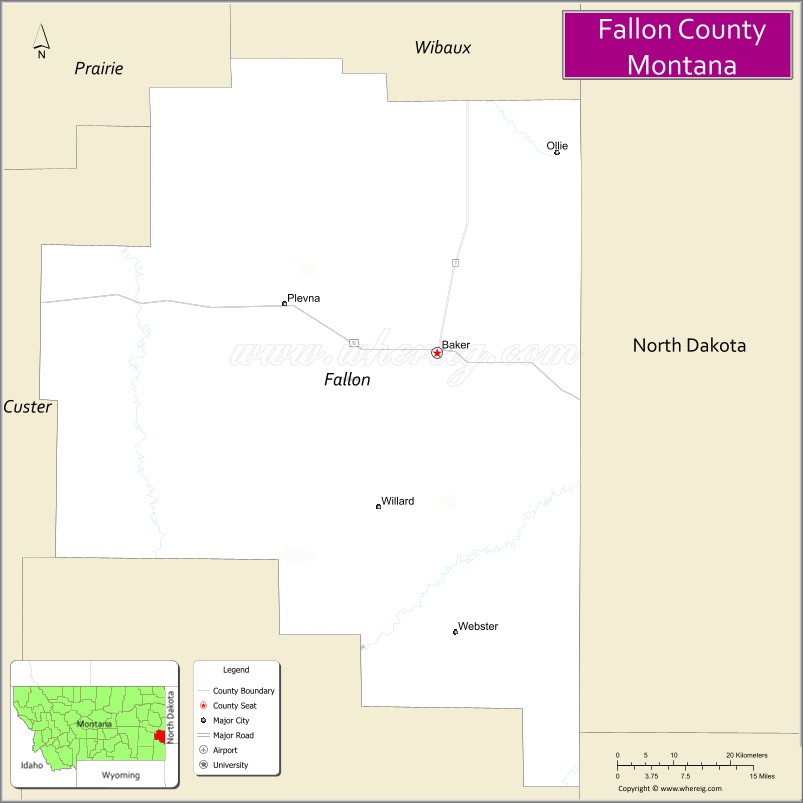
About Fallon County Map, Montana: The map showing the county boundary, county seat, major cities, highways, water bodies and neighbouring counties.
Other Montana Maps & Info
Map of Fallon County, Montana
Fallon County is a county located in the U.S. state of Montana. It's county seat is Baker. As per 2020 census, the population of Fallon County is 3017 people and population density is square miles. According to the United States Census Bureau, the county has a total area of 1,620 sq mi (4,196 km2). Fallon County was established on 5092.
Fallon County Facts
| Continent | North America |
| Country | United States |
| State | Montana |
| County Seat | Baker |
| Largest City/Town | Baker |
| Established | 1913 |
| Total Area | 1,623 sq mi (4,204 sq km) |
| Land Area | 1,621 sq mi (4,198 sq km) |
| Water Area | 2 sq mi (6 sq km) |
| Population | 3,049 (Census 2020) |
| Population Density | 1.9 people per sq mi |
| Time Zone | Mountain Time Zone (MST/MDT) |
| Major Highways | U.S. Route 12, Montana Highway 7 |
| Major Rivers | Little Beaver Creek, O'Fallon Creek |
| Neighboring Counties | Dawson County, Custer County, Carter County, Wibaux County, Slope County (ND) |
| Famous For | Prairie ranching, oil production, and Medicine Rocks region proximity |
| Top Attractions | Baker Lake, Fallon County Museum, Medicine Rocks nearby region, and prairie recreation areas |
| Official Website | Official Website |
About Fallon County, Montana
Fallon County is located in southeastern Montana in the western United States and was established in 1913. The county seat and largest city is Baker. The county is known for its agricultural economy, ranching traditions, prairie scenery, and energy production in Montana’s eastern plains region.
Cities and Towns in Fallon County, Montana
| City/Town | Population (Census 2020) | Latitude & Longitude |
|---|---|---|
| Baker (county seat) | 1,802 | 46.3664°N, 104.2777°W |
| Plevna | 162 | 46.4113°N, 104.5164°W |
| Willard (CDP) | 18 | 46.1615°N, 104.3698°W |
| Westmore (Rural Community) | 27 | 46.5172°N, 104.1644°W |
| Ollie (Nearby Community) | 21 | 46.4718°N, 104.7237°W |
| Mill Iron (Rural Community) | 15 | 45.9324°N, 104.2691°W |
Golf Courses in Fallon County, Montana
| Golf Course | Location | Latitude & Longitude |
|---|---|---|
| Lakeview Country Club | Baker | 46.3732°N, 104.2864°W |
| Fallon County Recreation Golf Area | Baker | 46.3685°N, 104.2812°W |
Major Roads and Highways in Fallon County, Montana
Major highways connect the county with southeastern Montana and western North Dakota communities.
- U.S. Route 12 - important east-west highway serving Baker and regional prairie communities
- Montana Highway 7 - north-south route connecting Fallon County with Glendive and Ekalaka
What are the Neighboring Counties of Fallon County
- Dawson County (northwest)
- Wibaux County (north)
- Custer County (west)
- Carter County (southwest)
- Slope County, North Dakota (east)
What are the top Attractions in Fallon County, Montana
The county offers a mix of prairie recreation, local history, and scenic eastern Montana landscapes.
- Baker Lake - recreational lake popular for fishing, boating, and camping
- Fallon County Museum - museum featuring pioneer history, ranching exhibits, and local artifacts
- Medicine Rocks State Park nearby region - scenic sandstone formations and hiking opportunities
- Downtown Baker Historic District - local shops, historic buildings, and community events
- Lakeview Country Club Recreation Area - golf and outdoor recreation destination
- Plevna Heritage Sites - historic agricultural and immigrant community landmarks
- Prairie Scenic Drives - countryside routes through rolling plains and ranchlands
- O'Fallon Creek Recreation Areas - outdoor destinations for wildlife viewing and fishing
- Eastern Montana Fossil Regions - nearby fossil discovery and badlands areas
- Little Beaver Creek Valley - scenic prairie and ranching landscapes
Distance from Fallon County to Nearby Cities
The following distances are measured by road (driving).
- Baker to Glendive (Dawson County), Montana - 51 mi (82 km)
- Baker to Miles City (Custer County), Montana - 82 mi (132 km)
- Baker to Ekalaka (Carter County), Montana - 38 mi (61 km)
- Baker to Dickinson (Stark County), North Dakota - 74 mi (119 km)
- Baker to Williston (Williams County), North Dakota - 133 mi (214 km)
- Baker to Bismarck (Burleigh County), North Dakota - 174 mi (280 km)
- Baker to Billings (Yellowstone County), Montana - 225 mi (362 km)
- Baker to Plevna (Fallon County), Montana - 9 mi (14 km)
- Baker to Rapid City (Pennington County), South Dakota - 241 mi (388 km)
- Baker to Sidney (Richland County), Montana - 129 mi (208 km)
- Baker to Bozeman (Gallatin County), Montana - 368 mi (592 km)
- Baker to Fargo (Cass County), North Dakota - 325 mi (523 km)
- Baker to Denver (Denver County), Colorado - 559 mi (900 km)
FAQs about Fallon County
Fallon County is located in southeastern Montana near the North Dakota border.
Fallon County had a population of 3,049 according to the 2020 United States Census.
Fallon County is known for ranching, prairie scenery, oil production, and outdoor recreation.
The county is served by U.S. Route 12 and Montana Highway 7.
Yes, Fallon County includes golf facilities such as Lakeview Country Club and recreation golf areas in Baker.
References
- QuickFacts - U.S. Census Bureau
- United States Census Bureau
- United States Geological Survey (USGS)
- National Geodetic Survey
- Official Website
- Beaverhead County Map
- Big Horn County Map
- Blaine County Map
- Broadwater County Map
- Carbon County Map
- Carter County Map
- Cascade County Map
- Chouteau County Map
- Custer County Map
- Daniels County Map
- Dawson County Map
- Deer Lodge County Map
- Fallon County Map
- Fergus County Map
- Flathead County Map
- Gallatin County Map
- Garfield County Map
- Glacier County Map
- Golden Valley County Map
- Granite County Map
- Hill County Map
- Jefferson County Map
- Judith Basin County Map
- Lake County Map
- Lewis and Clark County Map
- Liberty County Map
- Lincoln County Map
- McCone County Map
- Madison County Map
- Meagher County Map
- Mineral County Map
- Missoula County Map
- Musselshell County Map
- Park County Map
- Petroleum County Map
- Phillips County Map
- Pondera County Map
- Powder River County Map
- Powell County Map
- Prairie County Map
- Ravalli County Map
- Richland County Map
- Roosevelt County Map
- Rosebud County Map
- Sanders County Map
- Sheridan County Map
- Silver Bow County Map
- Stillwater County Map
- Sweet Grass County Map
- Teton County Map
- Toole County Map
- Treasure County Map
- Valley County Map
- Wheatland County Map
- Wibaux County Map
- Yellowstone County Map
- Alabama Counties
- Alaska boroughs
- Arizona Counties
- Arkansas Counties
- California County Map
- Colorado Counties
- Connecticut Counties
- Delaware Counties
- Florida County Map
- Georgia County Map
- Hawaii Counties
- Idaho Counties
- Illinois Counties
- Indiana Counties
- Iowa Counties
- Kansas Counties
- Kentucky Counties
- Louisiana Counties
- Maine Counties
- Maryland Counties
- Massachusetts Counties
- Michigan County Map
- Minnesota Counties
- Mississippi Counties
- Missouri Counties
- Montana Counties
- Nebraska Counties
- Nevada Counties
- New York Counties
- New Hampshire Counties
- New Jersey Counties
- New Mexico Counties
- North Carolina Counties
- North Dakota Counties
- Ohio County Map
- Oklahoma Counties
- Oregon Counties
- Pennsylvania Counties
- Rhode Island Counties
- South Carolina Counties
- South Dakota Counties
- Map of Tennessee
- Texas County Map
- Utah Counties
- Vermont Counties
- Virginia Counties
- Washington Counties
- West Virginia Counties
- Wisconsin Counties
- Wyoming Counties