Map of Richland County - Richland County is a county located in the U.S. state of Montana. Richland County Map showing cities, highways, important places and water bodies. Get Where is Richland County located in the map, major cities in Richland county, population, areas, and places of interest.
Map of Richland County, Montana
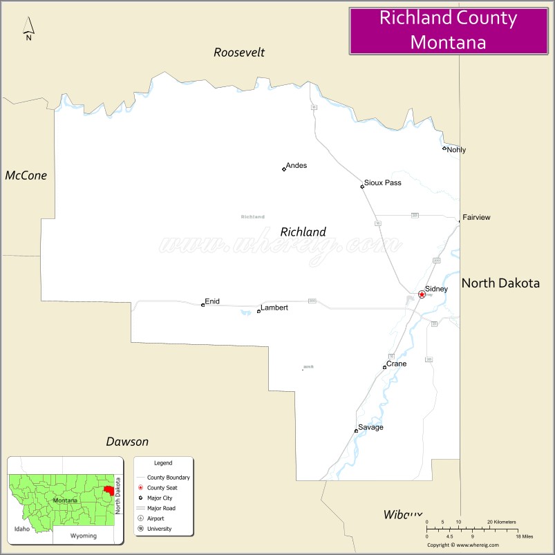
About Richland County Map, Montana: The map showing the county boundary, county seat, major cities, highways, water bodies and neighbouring counties.
Other Montana Maps & Info
Map of Richland County, Montana
Richland County is a county located in the U.S. state of Montana. It's county seat is Sidney. As per 2020 census, the population of Richland County is 11283 people and population density is square miles. According to the United States Census Bureau, the county has a total area of 2,084 sq mi (5,398 km2). Richland County was established on 5261.
Richland County Facts
| Continent | North America |
| Country | United States |
| State | Montana |
| County Seat | Sidney |
| Largest City/Town | Sidney |
| Established | 1914 |
| Total Area | 2,148 sq mi (5,563 sq km) |
| Land Area | 2,103 sq mi (5,447 sq km) |
| Water Area | 45 sq mi (117 sq km) |
| Population | 11,491 (Census 2020) |
| Population Density | 5.5 people per sq mi |
| Time Zone | Mountain Time Zone (MST/MDT) |
| Major Highways | Montana Highway 16, Montana Highway 200, U.S. Route 2 nearby region |
| Major Rivers | Yellowstone River, Missouri River nearby region |
| Neighboring Counties | Roosevelt County, Dawson County, McCone County, Wibaux County |
| Famous For | Oil production, agriculture, Yellowstone River Valley, and Bakken energy region |
| Top Attractions | Yellowstone River, MonDak Heritage Center, Sidney historic district, and nearby Fort Union Trading Post region |
| Official Website | Official Website |
About Richland County, Montana
Richland County is located in northeastern Montana in the western United States and was established in 1914. The county seat and largest city is Sidney. The county is known for its agricultural production, oil industry activity in the Bakken region, scenic Yellowstone River Valley, and strong western heritage traditions.
Cities and Towns in Richland County, Montana
| City/Town | Population (Census 2020) | Latitude & Longitude |
|---|---|---|
| Sidney (county seat) | 6,346 | 47.7164°N, 104.1566°W |
| Fairview | 896 | 47.8500°N, 104.0455°W |
| Savage | 708 | 47.4563°N, 104.3405°W |
| Lambert | 185 | 47.7827°N, 104.6499°W |
| Richey (Nearby Community) | 177 | 47.6644°N, 104.8506°W |
| Crane (CDP) | 102 | 47.7489°N, 104.2602°W |
Golf Courses in Richland County, Montana
| Golf Course | Location | Latitude & Longitude |
|---|---|---|
| Sidney Country Club | Sidney | 47.7229°N, 104.1638°W |
| Fairview Golf Course | Fairview | 47.8562°N, 104.0527°W |
Major Roads and Highways in Richland County, Montana
Major highways connect the county with northeastern Montana agricultural and energy-producing regions.
- Montana Highway 16 - major north-south route through the Yellowstone River Valley
- Montana Highway 200 - important east-west highway across eastern Montana
- U.S. Route 2 nearby region - regional transportation corridor in northern Montana
What are the Neighboring Counties of Richland County
- Roosevelt County (north)
- McCone County (west)
- Dawson County (southwest)
- Wibaux County (south)
What are the top Attractions in Richland County, Montana
The county offers a mix of river recreation, western history, and prairie landscapes.
- Yellowstone River - fishing, boating, and scenic river recreation destination
- MonDak Heritage Center - museum featuring regional history, art, and cultural exhibits
- Sidney Historic District - downtown area with western architecture and local shops
- Fort Union Trading Post nearby region - historic fur trading post and frontier landmark
- Richland County Fairgrounds - events venue hosting rodeos, fairs, and agricultural activities
- Eastern Montana Prairie Scenic Drives - open countryside routes through ranchlands and river valleys
- Fairview Agricultural Heritage Sites - attractions celebrating farming and ranching history
- Missouri River Recreation nearby region - boating, fishing, and wildlife viewing opportunities
- Oil Industry Heritage Areas - exhibits and sites connected to the Bakken energy region
- Wildlife Observation Areas - habitats for deer, antelope, waterfowl, and migratory birds
Distance from Richland County to Nearby Cities
The following distances are measured by road (driving).
- Sidney to Williston (Williams County), North Dakota - 49 mi (79 km)
- Sidney to Glendive (Dawson County), Montana - 78 mi (126 km)
- Sidney to Miles City (Custer County), Montana - 155 mi (249 km)
- Sidney to Bismarck (Burleigh County), North Dakota - 221 mi (356 km)
- Sidney to Billings (Yellowstone County), Montana - 279 mi (449 km)
- Sidney to Fairview (Richland County), Montana - 11 mi (18 km)
- Sidney to Savage (Richland County), Montana - 18 mi (29 km)
- Sidney to Minot (Ward County), North Dakota - 212 mi (341 km)
- Sidney to Rapid City (Pennington County), South Dakota - 401 mi (645 km)
- Sidney to Bozeman (Gallatin County), Montana - 410 mi (660 km)
- Sidney to Helena (Lewis and Clark County), Montana - 423 mi (681 km)
- Sidney to Denver (Denver County), Colorado - 670 mi (1,078 km)
- Sidney to Minneapolis (Hennepin County), Minnesota - 705 mi (1,135 km)
FAQs about Richland County
Richland County is located in northeastern Montana in the Yellowstone River Valley region.
Richland County had a population of 11,491 according to the 2020 United States Census.
Richland County is known for agriculture, oil production, prairie scenery, and Yellowstone River recreation.
The county is served by Montana Highway 16 and Montana Highway 200.
Yes, Richland County includes golf facilities such as Sidney Country Club and Fairview Golf Course.
References
- QuickFacts - U.S. Census Bureau
- United States Census Bureau
- United States Geological Survey (USGS)
- National Geodetic Survey
- Official Website
- Beaverhead County Map
- Big Horn County Map
- Blaine County Map
- Broadwater County Map
- Carbon County Map
- Carter County Map
- Cascade County Map
- Chouteau County Map
- Custer County Map
- Daniels County Map
- Dawson County Map
- Deer Lodge County Map
- Fallon County Map
- Fergus County Map
- Flathead County Map
- Gallatin County Map
- Garfield County Map
- Glacier County Map
- Golden Valley County Map
- Granite County Map
- Hill County Map
- Jefferson County Map
- Judith Basin County Map
- Lake County Map
- Lewis and Clark County Map
- Liberty County Map
- Lincoln County Map
- McCone County Map
- Madison County Map
- Meagher County Map
- Mineral County Map
- Missoula County Map
- Musselshell County Map
- Park County Map
- Petroleum County Map
- Phillips County Map
- Pondera County Map
- Powder River County Map
- Powell County Map
- Prairie County Map
- Ravalli County Map
- Richland County Map
- Roosevelt County Map
- Rosebud County Map
- Sanders County Map
- Sheridan County Map
- Silver Bow County Map
- Stillwater County Map
- Sweet Grass County Map
- Teton County Map
- Toole County Map
- Treasure County Map
- Valley County Map
- Wheatland County Map
- Wibaux County Map
- Yellowstone County Map
- Alabama Counties
- Alaska boroughs
- Arizona Counties
- Arkansas Counties
- California County Map
- Colorado Counties
- Connecticut Counties
- Delaware Counties
- Florida County Map
- Georgia County Map
- Hawaii Counties
- Idaho Counties
- Illinois Counties
- Indiana Counties
- Iowa Counties
- Kansas Counties
- Kentucky Counties
- Louisiana Counties
- Maine Counties
- Maryland Counties
- Massachusetts Counties
- Michigan County Map
- Minnesota Counties
- Mississippi Counties
- Missouri Counties
- Montana Counties
- Nebraska Counties
- Nevada Counties
- New York Counties
- New Hampshire Counties
- New Jersey Counties
- New Mexico Counties
- North Carolina Counties
- North Dakota Counties
- Ohio County Map
- Oklahoma Counties
- Oregon Counties
- Pennsylvania Counties
- Rhode Island Counties
- South Carolina Counties
- South Dakota Counties
- Map of Tennessee
- Texas County Map
- Utah Counties
- Vermont Counties
- Virginia Counties
- Washington Counties
- West Virginia Counties
- Wisconsin Counties
- Wyoming Counties