Map of Silver Bow County - Silver Bow County is a county located in the U.S. state of Montana. Silver Bow County Map showing cities, highways, important places and water bodies. Get Where is Silver Bow County located in the map, major cities in Silver Bow county, population, areas, and places of interest.
Map of Silver Bow County, Montana
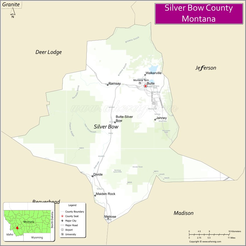
About Silver Bow County Map, Montana: The map showing the county boundary, county seat, major cities, highways, water bodies and neighbouring counties.
Other Montana Maps & Info
Map of Silver Bow County, Montana
Silver Bow County is a county located in the U.S. state of Montana. It's county seat is Butte. As per 2020 census, the population of Silver Bow County is 35411 people and population density is square miles. According to the United States Census Bureau, the county has a total area of 718 sq mi (1,860 km2). Silver Bow County was established on -6891.
Silver Bow County Facts
| Continent | North America |
| Country | United States |
| State | Montana |
| County Seat | Butte |
| Largest City/Town | Butte |
| Established | 1881 |
| Total Area | 718 sq mi (1,860 sq km) |
| Land Area | 716 sq mi (1,854 sq km) |
| Water Area | 2 sq mi (6 sq km) |
| Population | 34,494 (Census 2020) |
| Population Density | 48.2 people per sq mi |
| Time Zone | Mountain Time Zone (MST/MDT) |
| Major Highways | Interstate 90, Interstate 15, Montana Highway 2 |
| Major Rivers | Clark Fork River headwaters, Big Hole River nearby region |
| Neighboring Counties | Deer Lodge County, Jefferson County, Madison County, Beaverhead County |
| Famous For | Historic mining industry, Butte copper mines, Irish heritage, and mountain scenery |
| Top Attractions | World Museum of Mining, Berkeley Pit, Butte Historic District, and Our Lady of the Rockies |
| Official Website | Official Website |
About Silver Bow County, Montana
Silver Bow County is located in southwestern Montana in the western United States and was established in 1881. The county seat and largest city is Butte. The county is known for its rich mining history, copper production, historic architecture, Irish-American heritage, and scenic Rocky Mountain surroundings.
Cities and Towns in Silver Bow County, Montana
| City/Town | Population (Census 2020) | Latitude & Longitude |
|---|---|---|
| Butte (county seat) | 34,494 | 46.0038°N, 112.5347°W |
| Walkerville | 714 | 46.0374°N, 112.5308°W |
| Rocker | 132 | 46.0361°N, 112.6404°W |
| Ramsay | 477 | 45.9578°N, 112.6645°W |
| Divide | 221 | 45.7571°N, 112.5627°W |
| Feely (Historic Community) | 43 | 46.1047°N, 112.4853°W |
Golf Courses in Silver Bow County, Montana
| Golf Course | Location | Latitude & Longitude |
|---|---|---|
| Butte Country Club | Butte | 46.0109°N, 112.5418°W |
| Highland View Golf Course | Butte | 46.0196°N, 112.5487°W |
Major Roads and Highways in Silver Bow County, Montana
Major highways connect the county with southwestern Montana cities and mountain recreation areas.
- Interstate 90 - major east-west interstate through Montana
- Interstate 15 - north-south interstate connecting Montana with Idaho and Canada
- Montana Highway 2 - regional route serving local communities and recreation areas
What are the Neighboring Counties of Silver Bow County
- Deer Lodge County (north)
- Jefferson County (east)
- Madison County (southeast)
- Beaverhead County (southwest)
What are the top Attractions in Silver Bow County, Montana
The county offers a mix of mining history, mountain scenery, and cultural attractions.
- World Museum of Mining - large museum showcasing Butte’s mining history and underground tours
- Berkeley Pit - famous former open-pit copper mine and environmental landmark
- Butte Historic District - preserved historic architecture and mining-era neighborhoods
- Our Lady of the Rockies - large mountain-top statue overlooking Butte
- Old Lexington Stamp Mill and Gardens - restored mining history attraction
- Copper King Mansion - historic Victorian mansion linked to Montana mining wealth
- Big Butte Landmark - scenic overlook and historic symbol of the city
- Continental Divide Trail nearby region - hiking and outdoor recreation opportunities
- Butte Irish Festival and Cultural Events - celebrations of Irish-American heritage
- Rocky Mountain Scenic Drives - panoramic mountain roads and recreation areas
Distance from Silver Bow County to Nearby Cities
The following distances are measured by road (driving).
- Butte to Helena (Lewis and Clark County), Montana - 67 mi (108 km)
- Butte to Missoula (Missoula County), Montana - 120 mi (193 km)
- Butte to Bozeman (Gallatin County), Montana - 85 mi (137 km)
- Butte to Deer Lodge (Powell County), Montana - 36 mi (58 km)
- Butte to Dillon (Beaverhead County), Montana - 65 mi (105 km)
- Butte to Walkerville (Silver Bow County), Montana - 2 mi (3 km)
- Butte to Ramsay (Silver Bow County), Montana - 9 mi (14 km)
- Butte to Billings (Yellowstone County), Montana - 235 mi (378 km)
- Butte to Spokane (Spokane County), Washington - 286 mi (460 km)
- Butte to Salt Lake City (Salt Lake County), Utah - 432 mi (695 km)
- Butte to Denver (Denver County), Colorado - 690 mi (1,110 km)
- Butte to Calgary, Alberta - 458 mi (737 km)
- Butte to Seattle (King County), Washington - 548 mi (882 km)
FAQs about Silver Bow County
Silver Bow County is located in southwestern Montana in the Rocky Mountain region.
Silver Bow County had a population of 34,494 according to the 2020 United States Census.
Silver Bow County is known for mining history, copper production, Irish heritage, and mountain scenery.
The county is served by Interstate 90, Interstate 15, and Montana Highway 2.
Yes, Silver Bow County includes golf facilities such as Butte Country Club and Highland View Golf Course.
References
- QuickFacts - U.S. Census Bureau
- United States Census Bureau
- United States Geological Survey (USGS)
- National Geodetic Survey
- Official Website
- Beaverhead County Map
- Big Horn County Map
- Blaine County Map
- Broadwater County Map
- Carbon County Map
- Carter County Map
- Cascade County Map
- Chouteau County Map
- Custer County Map
- Daniels County Map
- Dawson County Map
- Deer Lodge County Map
- Fallon County Map
- Fergus County Map
- Flathead County Map
- Gallatin County Map
- Garfield County Map
- Glacier County Map
- Golden Valley County Map
- Granite County Map
- Hill County Map
- Jefferson County Map
- Judith Basin County Map
- Lake County Map
- Lewis and Clark County Map
- Liberty County Map
- Lincoln County Map
- McCone County Map
- Madison County Map
- Meagher County Map
- Mineral County Map
- Missoula County Map
- Musselshell County Map
- Park County Map
- Petroleum County Map
- Phillips County Map
- Pondera County Map
- Powder River County Map
- Powell County Map
- Prairie County Map
- Ravalli County Map
- Richland County Map
- Roosevelt County Map
- Rosebud County Map
- Sanders County Map
- Sheridan County Map
- Silver Bow County Map
- Stillwater County Map
- Sweet Grass County Map
- Teton County Map
- Toole County Map
- Treasure County Map
- Valley County Map
- Wheatland County Map
- Wibaux County Map
- Yellowstone County Map
- Alabama Counties
- Alaska boroughs
- Arizona Counties
- Arkansas Counties
- California County Map
- Colorado Counties
- Connecticut Counties
- Delaware Counties
- Florida County Map
- Georgia County Map
- Hawaii Counties
- Idaho Counties
- Illinois Counties
- Indiana Counties
- Iowa Counties
- Kansas Counties
- Kentucky Counties
- Louisiana Counties
- Maine Counties
- Maryland Counties
- Massachusetts Counties
- Michigan County Map
- Minnesota Counties
- Mississippi Counties
- Missouri Counties
- Montana Counties
- Nebraska Counties
- Nevada Counties
- New York Counties
- New Hampshire Counties
- New Jersey Counties
- New Mexico Counties
- North Carolina Counties
- North Dakota Counties
- Ohio County Map
- Oklahoma Counties
- Oregon Counties
- Pennsylvania Counties
- Rhode Island Counties
- South Carolina Counties
- South Dakota Counties
- Map of Tennessee
- Texas County Map
- Utah Counties
- Vermont Counties
- Virginia Counties
- Washington Counties
- West Virginia Counties
- Wisconsin Counties
- Wyoming Counties