Map of Wibaux County - Wibaux County is a county located in the U.S. state of Montana. Wibaux County Map showing cities, highways, important places and water bodies. Get Where is Wibaux County located in the map, major cities in Wibaux county, population, areas, and places of interest.
Map of Wibaux County, Montana
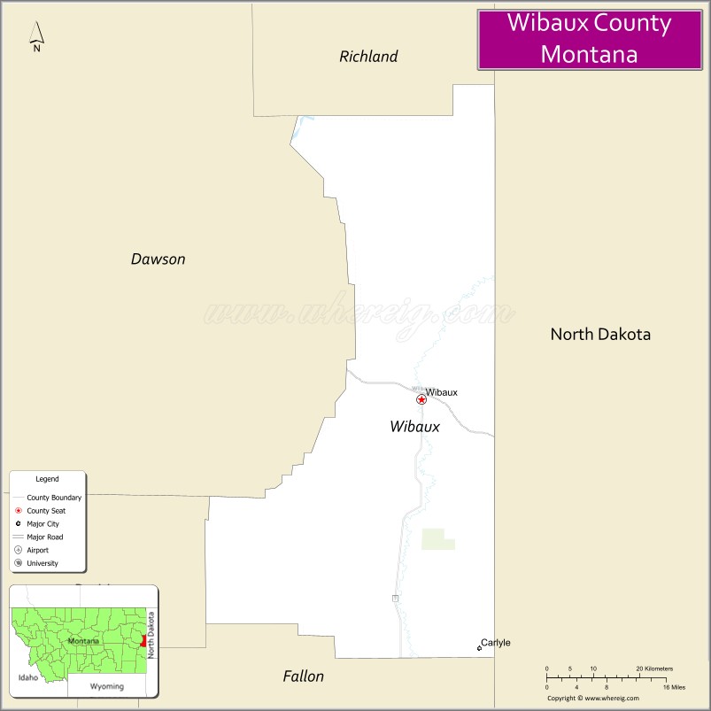
About Wibaux County Map, Montana: The map showing the county boundary, county seat, major cities, highways, water bodies and neighbouring counties.
Other Montana Maps & Info
Map of Wibaux County, Montana
Wibaux County is a county located in the U.S. state of Montana. It's county seat is Wibaux. As per 2020 census, the population of Wibaux County is 934 people and population density is square miles. According to the United States Census Bureau, the county has a total area of 889 sq mi (2,302 km2). Wibaux County was established on 5343.
Wibaux County Facts
| Continent | North America |
| Country | United States |
| State | Montana |
| County Seat | Wibaux |
| Largest City/Town | Wibaux |
| Established | 1914 |
| Total Area | 889 sq mi (2,302 sq km) |
| Land Area | 889 sq mi (2,302 sq km) |
| Water Area | 0.2 sq mi (0.5 sq km) |
| Population | 937 (Census 2020) |
| Population Density | 1.1 people per sq mi |
| Time Zone | Mountain Time Zone (MST/MDT) |
| Major Highways | Interstate 94, Montana Highway 7 |
| Major Rivers | Beaver Creek, Yellowstone River nearby region |
| Neighboring Counties | Dawson County, Prairie County, Fallon County |
| Famous For | Prairie ranchlands, historic western heritage, dinosaur fossil regions nearby, and scenic badlands |
| Top Attractions | Wibaux Museum, Beaver Creek recreation areas, prairie scenic drives, and nearby badlands landscapes |
| Official Website | Official Website |
About Wibaux County, Montana
Wibaux County is located in eastern Montana in the western United States and was established in 1914. The county seat and largest town is Wibaux. The county is known for its ranching economy, prairie scenery, western heritage, and quiet badlands landscapes near the Montana–North Dakota border.
Cities and Towns in Wibaux County, Montana
| City/Town | Population (Census 2020) | Latitude & Longitude |
|---|---|---|
| Wibaux (county seat) | 589 | 46.9850°N, 104.1885°W |
| Stipek Ranch Area | 41 | 46.8917°N, 104.2653°W |
| Yates Community | 22 | 47.0834°N, 104.0771°W |
| Beaver Creek Valley | 37 | 46.9362°N, 104.3027°W |
| Rural Prairie Region | 55 | 47.0215°N, 104.4102°W |
| West Wibaux Area | 29 | 46.9708°N, 104.3419°W |
Golf Courses in Wibaux County, Montana
| Golf Course | Location | Latitude & Longitude |
|---|---|---|
| Wibaux Country Club Golf Course | Wibaux | 46.9916°N, 104.1954°W |
| Prairie Hills Golf Recreation Area | Beaver Creek Valley | 46.9428°N, 104.3095°W |
Major Roads and Highways in Wibaux County, Montana
Major highways connect the county with eastern Montana prairie communities and nearby North Dakota regions.
- Interstate 94 - major east-west interstate through eastern Montana
- Montana Highway 7 - regional route serving ranchlands and prairie communities
What are the Neighboring Counties of Wibaux County
- Dawson County (northwest)
- Prairie County (west)
- Fallon County (south)
What are the top Attractions in Wibaux County, Montana
The county offers a mix of prairie scenery, western history, and outdoor recreation.
- Wibaux Museum - exhibits on pioneer settlement, ranching, and railroad history
- Beaver Creek Recreation Areas - fishing, wildlife viewing, and prairie landscapes
- Prairie Scenic Drives - panoramic countryside routes through ranchlands and badlands terrain
- Nearby Badlands Landscapes - rugged eastern Montana formations ideal for photography
- Historic Downtown Wibaux - preserved western-style architecture and community landmarks
- Open Prairie Wildlife Areas - habitats for deer, antelope, upland birds, and migratory species
- Eastern Montana Ranching Regions - authentic open-range scenery and western culture
- Railroad Heritage Sites - historic transportation landmarks from the early settlement era
- Yellowstone River Nearby Recreation - boating and fishing opportunities within driving distance
- Quiet Rural Stargazing Areas - dark-sky prairie landscapes ideal for night photography
Distance from Wibaux County to Nearby Cities
The following distances are measured by road (driving).
- Wibaux to Glendive (Dawson County), Montana - 42 mi (68 km)
- Wibaux to Miles City (Custer County), Montana - 93 mi (150 km)
- Wibaux to Sidney (Richland County), Montana - 104 mi (167 km)
- Wibaux to Dickinson (Stark County), North Dakota - 88 mi (142 km)
- Wibaux to Bismarck (Burleigh County), North Dakota - 190 mi (306 km)
- Wibaux to Billings (Yellowstone County), Montana - 243 mi (391 km)
- Wibaux to Rapid City (Pennington County), South Dakota - 268 mi (431 km)
- Wibaux to Bozeman (Gallatin County), Montana - 374 mi (602 km)
- Wibaux to Helena (Lewis and Clark County), Montana - 386 mi (621 km)
- Wibaux to Fargo (Cass County), North Dakota - 356 mi (573 km)
- Wibaux to Denver (Denver County), Colorado - 598 mi (962 km)
- Wibaux to Minneapolis (Hennepin County), Minnesota - 676 mi (1,088 km)
- Wibaux to Spokane (Spokane County), Washington - 638 mi (1,027 km)
FAQs about Wibaux County
Wibaux County is located in eastern Montana near the Montana–North Dakota border.
Wibaux County had a population of 937 according to the 2020 United States Census.
Wibaux County is known for prairie ranchlands, western heritage, badlands scenery, and quiet rural landscapes.
The county is served by Interstate 94 and Montana Highway 7.
Yes, Wibaux County includes golf facilities such as Wibaux Country Club Golf Course and Prairie Hills Golf Recreation Area.
References
- QuickFacts - U.S. Census Bureau
- United States Census Bureau
- United States Geological Survey (USGS)
- National Geodetic Survey
- Official Website
- Beaverhead County Map
- Big Horn County Map
- Blaine County Map
- Broadwater County Map
- Carbon County Map
- Carter County Map
- Cascade County Map
- Chouteau County Map
- Custer County Map
- Daniels County Map
- Dawson County Map
- Deer Lodge County Map
- Fallon County Map
- Fergus County Map
- Flathead County Map
- Gallatin County Map
- Garfield County Map
- Glacier County Map
- Golden Valley County Map
- Granite County Map
- Hill County Map
- Jefferson County Map
- Judith Basin County Map
- Lake County Map
- Lewis and Clark County Map
- Liberty County Map
- Lincoln County Map
- McCone County Map
- Madison County Map
- Meagher County Map
- Mineral County Map
- Missoula County Map
- Musselshell County Map
- Park County Map
- Petroleum County Map
- Phillips County Map
- Pondera County Map
- Powder River County Map
- Powell County Map
- Prairie County Map
- Ravalli County Map
- Richland County Map
- Roosevelt County Map
- Rosebud County Map
- Sanders County Map
- Sheridan County Map
- Silver Bow County Map
- Stillwater County Map
- Sweet Grass County Map
- Teton County Map
- Toole County Map
- Treasure County Map
- Valley County Map
- Wheatland County Map
- Wibaux County Map
- Yellowstone County Map
- Alabama Counties
- Alaska boroughs
- Arizona Counties
- Arkansas Counties
- California County Map
- Colorado Counties
- Connecticut Counties
- Delaware Counties
- Florida County Map
- Georgia County Map
- Hawaii Counties
- Idaho Counties
- Illinois Counties
- Indiana Counties
- Iowa Counties
- Kansas Counties
- Kentucky Counties
- Louisiana Counties
- Maine Counties
- Maryland Counties
- Massachusetts Counties
- Michigan County Map
- Minnesota Counties
- Mississippi Counties
- Missouri Counties
- Montana Counties
- Nebraska Counties
- Nevada Counties
- New York Counties
- New Hampshire Counties
- New Jersey Counties
- New Mexico Counties
- North Carolina Counties
- North Dakota Counties
- Ohio County Map
- Oklahoma Counties
- Oregon Counties
- Pennsylvania Counties
- Rhode Island Counties
- South Carolina Counties
- South Dakota Counties
- Map of Tennessee
- Texas County Map
- Utah Counties
- Vermont Counties
- Virginia Counties
- Washington Counties
- West Virginia Counties
- Wisconsin Counties
- Wyoming Counties