Map of Mineral County - Mineral County is a county located in the U.S. state of Montana. Mineral County Map showing cities, highways, important places and water bodies. Get Where is Mineral County located in the map, major cities in Mineral county, population, areas, and places of interest.
Map of Mineral County, Montana
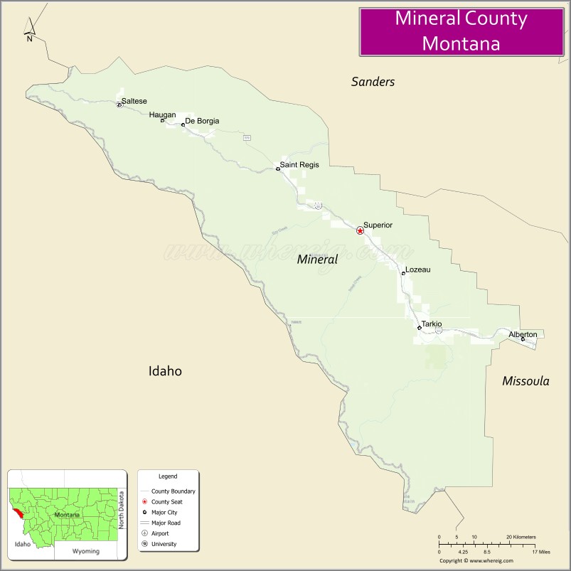
About Mineral County Map, Montana: The map showing the county boundary, county seat, major cities, highways, water bodies and neighbouring counties.
Other Montana Maps & Info
Map of Mineral County, Montana
Mineral County is a county located in the U.S. state of Montana. It's county seat is Superior. As per 2020 census, the population of Mineral County is 4860 people and population density is square miles. According to the United States Census Bureau, the county has a total area of 1,220 sq mi (3,160 km2). Mineral County was established on 5333.
Mineral County Facts
| Continent | North America |
| Country | United States |
| State | Montana |
| County Seat | Superior |
| Largest City/Town | Superior |
| Established | 1914 |
| Total Area | 1,223 sq mi (3,168 sq km) |
| Land Area | 1,219 sq mi (3,157 sq km) |
| Water Area | 4 sq mi (11 sq km) |
| Population | 4,535 (Census 2020) |
| Population Density | 3.7 people per sq mi |
| Time Zone | Mountain Time Zone (MST/MDT) |
| Major Highways | Interstate 90, U.S. Route 10 |
| Major Rivers | Clark Fork River, St. Regis River |
| Neighboring Counties | Missoula County, Sanders County, Ravalli County |
| Famous For | Lolo National Forest, mountain recreation, fishing rivers, and scenic wilderness |
| Top Attractions | Lolo National Forest, Alberton Gorge nearby region, St. Regis Travel Center, and Clark Fork River recreation |
| Official Website | Official Website |
About Mineral County, Montana
Mineral County is located in western Montana in the western United States and was established in 1914. The county seat and largest town is Superior. The county is known for its rugged mountain scenery, forest recreation, river rafting, fishing opportunities, and scenic routes through the Northern Rockies.
Cities and Towns in Mineral County, Montana
| City/Town | Population (Census 2020) | Latitude & Longitude |
|---|---|---|
| Superior (county seat) | 812 | 47.1916°N, 114.8915°W |
| St. Regis | 319 | 47.3030°N, 115.1005°W |
| Alberton | 452 | 47.0066°N, 114.4829°W |
| Saltese (CDP) | 12 | 47.4080°N, 115.5376°W |
| De Borgia (CDP) | 65 | 47.3714°N, 115.4352°W |
| Taft (Historic Community) | 24 | 47.4357°N, 115.6874°W |
Golf Courses in Mineral County, Montana
| Golf Course | Location | Latitude & Longitude |
|---|---|---|
| River’s Bend Golf Recreation Area | Superior | 47.1974°N, 114.8978°W |
| St. Regis Valley Golf Area | St. Regis | 47.3081°N, 115.1062°W |
Major Roads and Highways in Mineral County, Montana
Major highways connect the county with western Montana valleys and mountain recreation destinations.
- Interstate 90 - major east-west interstate through the Clark Fork River Valley
- U.S. Route 10 - historic highway serving local communities along the interstate corridor
What are the Neighboring Counties of Mineral County
- Missoula County (east)
- Sanders County (north)
- Ravalli County (south)
What are the top Attractions in Mineral County, Montana
The county offers a mix of mountain recreation, river adventures, and scenic forest landscapes.
- Lolo National Forest - expansive recreation area for hiking, camping, and wildlife viewing
- Alberton Gorge nearby region - popular whitewater rafting and kayaking destination on the Clark Fork River
- St. Regis Travel Center - well-known Montana roadside attraction and visitor stop
- Clark Fork River Recreation Areas - fishing, rafting, and riverside camping opportunities
- Lookout Pass Ski and Recreation Area nearby region - skiing and mountain recreation near the Idaho border
- Route of the Hiawatha nearby region - scenic rail-trail biking experience through mountain tunnels and trestles
- Superior Historic District - small-town center with local museums and historic architecture
- St. Regis River Valley - scenic river corridor with hiking and fishing opportunities
- Taft Tunnel Historic Area - historic railroad and mountain transportation landmarks
- Western Montana Scenic Drives - mountain highways with panoramic forest and canyon views
Distance from Mineral County to Nearby Cities
The following distances are measured by road (driving).
- Superior to Missoula (Missoula County), Montana - 57 mi (92 km)
- Superior to St. Regis (Mineral County), Montana - 11 mi (18 km)
- Superior to Alberton (Mineral County), Montana - 28 mi (45 km)
- Superior to Coeur d'Alene (Kootenai County), Idaho - 118 mi (190 km)
- Superior to Spokane (Spokane County), Washington - 159 mi (256 km)
- Superior to Kalispell (Flathead County), Montana - 165 mi (266 km)
- Superior to Helena (Lewis and Clark County), Montana - 170 mi (274 km)
- Superior to Bozeman (Gallatin County), Montana - 260 mi (418 km)
- Superior to Seattle (King County), Washington - 452 mi (727 km)
- Superior to Billings (Yellowstone County), Montana - 397 mi (639 km)
- Superior to Salt Lake City (Salt Lake County), Utah - 577 mi (928 km)
- Superior to Calgary, Alberta - 425 mi (684 km)
- Superior to Denver (Denver County), Colorado - 808 mi (1,300 km)
FAQs about Mineral County
Mineral County is located in western Montana near the Idaho border.
Mineral County had a population of 4,535 according to the 2020 United States Census.
Mineral County is known for mountain recreation, river rafting, forests, and scenic wilderness landscapes.
The county is served by Interstate 90 and U.S. Route 10.
Yes, Mineral County includes golf recreation facilities near Superior and St. Regis.
References
- QuickFacts - U.S. Census Bureau
- United States Census Bureau
- United States Geological Survey (USGS)
- National Geodetic Survey
- Official Website
- Beaverhead County Map
- Big Horn County Map
- Blaine County Map
- Broadwater County Map
- Carbon County Map
- Carter County Map
- Cascade County Map
- Chouteau County Map
- Custer County Map
- Daniels County Map
- Dawson County Map
- Deer Lodge County Map
- Fallon County Map
- Fergus County Map
- Flathead County Map
- Gallatin County Map
- Garfield County Map
- Glacier County Map
- Golden Valley County Map
- Granite County Map
- Hill County Map
- Jefferson County Map
- Judith Basin County Map
- Lake County Map
- Lewis and Clark County Map
- Liberty County Map
- Lincoln County Map
- McCone County Map
- Madison County Map
- Meagher County Map
- Mineral County Map
- Missoula County Map
- Musselshell County Map
- Park County Map
- Petroleum County Map
- Phillips County Map
- Pondera County Map
- Powder River County Map
- Powell County Map
- Prairie County Map
- Ravalli County Map
- Richland County Map
- Roosevelt County Map
- Rosebud County Map
- Sanders County Map
- Sheridan County Map
- Silver Bow County Map
- Stillwater County Map
- Sweet Grass County Map
- Teton County Map
- Toole County Map
- Treasure County Map
- Valley County Map
- Wheatland County Map
- Wibaux County Map
- Yellowstone County Map
- Alabama Counties
- Alaska boroughs
- Arizona Counties
- Arkansas Counties
- California County Map
- Colorado Counties
- Connecticut Counties
- Delaware Counties
- Florida County Map
- Georgia County Map
- Hawaii Counties
- Idaho Counties
- Illinois Counties
- Indiana Counties
- Iowa Counties
- Kansas Counties
- Kentucky Counties
- Louisiana Counties
- Maine Counties
- Maryland Counties
- Massachusetts Counties
- Michigan County Map
- Minnesota Counties
- Mississippi Counties
- Missouri Counties
- Montana Counties
- Nebraska Counties
- Nevada Counties
- New York Counties
- New Hampshire Counties
- New Jersey Counties
- New Mexico Counties
- North Carolina Counties
- North Dakota Counties
- Ohio County Map
- Oklahoma Counties
- Oregon Counties
- Pennsylvania Counties
- Rhode Island Counties
- South Carolina Counties
- South Dakota Counties
- Map of Tennessee
- Texas County Map
- Utah Counties
- Vermont Counties
- Virginia Counties
- Washington Counties
- West Virginia Counties
- Wisconsin Counties
- Wyoming Counties