Map of Ravalli County - Ravalli County is a county located in the U.S. state of Montana. Ravalli County Map showing cities, highways, important places and water bodies. Get Where is Ravalli County located in the map, major cities in Ravalli county, population, areas, and places of interest.
Map of Ravalli County, Montana
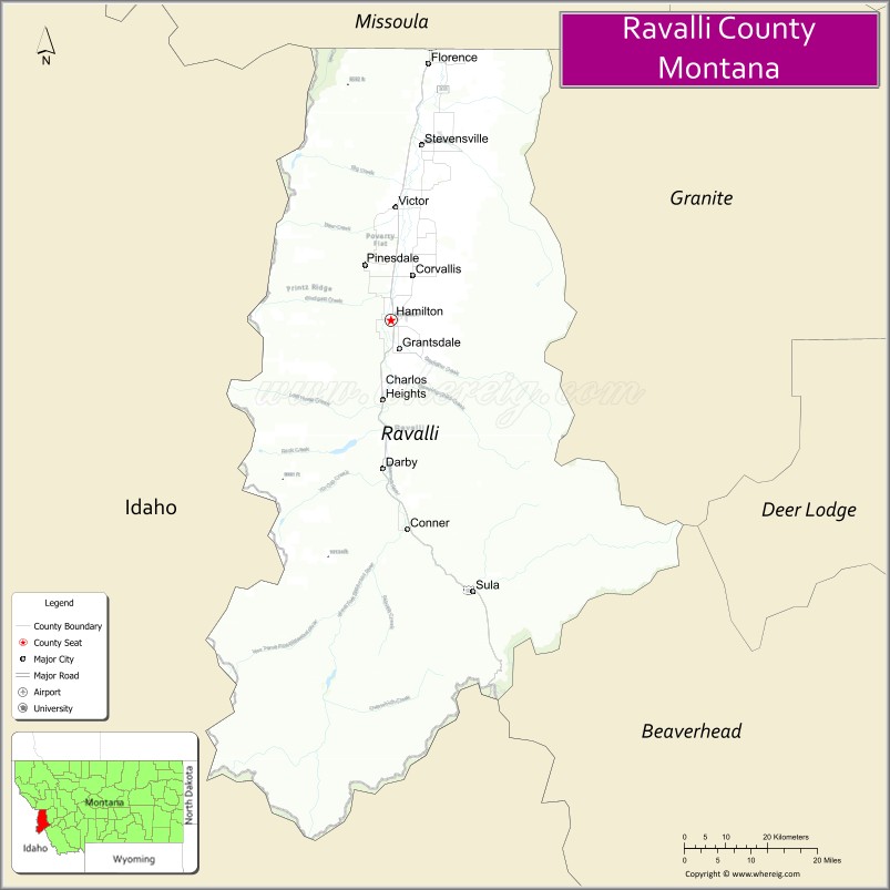
About Ravalli County Map, Montana: The map showing the county boundary, county seat, major cities, highways, water bodies and neighbouring counties.
Other Montana Maps & Info
Map of Ravalli County, Montana
Ravalli County is a county located in the U.S. state of Montana. It's county seat is Hamilton. As per 2020 census, the population of Ravalli County is 45959 people and population density is square miles. According to the United States Census Bureau, the county has a total area of 2,394 sq mi (6,200 km2). Ravalli County was established on -2508.
Ravalli County Facts
| Continent | North America |
| Country | United States |
| State | Montana |
| County Seat | Hamilton |
| Largest City/Town | Hamilton |
| Established | 1893 |
| Total Area | 2,405 sq mi (6,229 sq km) |
| Land Area | 2,391 sq mi (6,192 sq km) |
| Water Area | 14 sq mi (37 sq km) |
| Population | 44,174 (Census 2020) |
| Population Density | 18.5 people per sq mi |
| Time Zone | Mountain Time Zone (MST/MDT) |
| Major Highways | U.S. Route 93, Montana Highway 38 |
| Major Rivers | Bitterroot River |
| Neighboring Counties | Missoula County, Mineral County, Granite County, Beaverhead County |
| Famous For | Bitterroot Valley, mountain recreation, fly fishing, and historic western communities |
| Top Attractions | Lee Metcalf National Wildlife Refuge, Bitterroot National Forest, Daly Mansion, and Lost Trail Pass nearby region |
| Official Website | Official Website |
About Ravalli County, Montana
Ravalli County is located in western Montana in the western United States and was established in 1893. The county seat and largest town is Hamilton. The county is known for the scenic Bitterroot Valley, mountain recreation, outdoor tourism, fly fishing, and historic ranching communities surrounded by the Bitterroot and Sapphire mountain ranges.
Cities and Towns in Ravalli County, Montana
| City/Town | Population (Census 2020) | Latitude & Longitude |
|---|---|---|
| Hamilton (county seat) | 5,050 | 46.2471°N, 114.1540°W |
| Stevensville | 2,080 | 46.5099°N, 114.0918°W |
| Darby | 783 | 45.9991°N, 114.1781°W |
| Corvallis (CDP) | 1,065 | 46.3130°N, 114.1167°W |
| Victor | 843 | 46.4183°N, 114.1507°W |
| Florence (CDP) | 838 | 46.6363°N, 114.0808°W |
Golf Courses in Ravalli County, Montana
| Golf Course | Location | Latitude & Longitude |
|---|---|---|
| Hamilton Golf Club | Hamilton | 46.2537°N, 114.1608°W |
| Bitterroot Valley Golf Course | Corvallis | 46.3195°N, 114.1234°W |
Major Roads and Highways in Ravalli County, Montana
Major highways connect the county with western Montana valleys and mountain recreation destinations.
- U.S. Route 93 - major north-south highway through the Bitterroot Valley
- Montana Highway 38 - scenic route connecting communities with mountain recreation areas
What are the Neighboring Counties of Ravalli County
- Missoula County (north)
- Mineral County (west)
- Granite County (east)
- Beaverhead County (south)
What are the top Attractions in Ravalli County, Montana
The county offers a mix of mountain scenery, wildlife recreation, and western heritage attractions.
- Lee Metcalf National Wildlife Refuge - wetland refuge with birdwatching and walking trails
- Bitterroot National Forest - hiking, camping, fishing, and scenic mountain recreation
- Daly Mansion - historic estate connected to Montana copper industry history
- Lost Trail Pass nearby region - skiing, hiking, and mountain recreation area
- Bitterroot River - nationally known fly fishing and rafting destination
- St. Mary’s Mission in Stevensville - historic mission site and important Montana landmark
- Blodgett Canyon Recreation Area - dramatic mountain canyon hiking destination
- Hamilton Historic Downtown - western-style architecture, museums, and local businesses
- Sapphire Mountains Scenic Region - outdoor recreation and wildlife viewing opportunities
- Darby Western Heritage Sites - attractions linked to ranching and frontier culture
Distance from Ravalli County to Nearby Cities
The following distances are measured by road (driving).
- Hamilton to Missoula (Missoula County), Montana - 47 mi (76 km)
- Hamilton to Stevensville (Ravalli County), Montana - 28 mi (45 km)
- Hamilton to Darby (Ravalli County), Montana - 17 mi (27 km)
- Hamilton to Butte (Silver Bow County), Montana - 109 mi (175 km)
- Hamilton to Helena (Lewis and Clark County), Montana - 140 mi (225 km)
- Hamilton to Bozeman (Gallatin County), Montana - 204 mi (328 km)
- Hamilton to Kalispell (Flathead County), Montana - 190 mi (306 km)
- Hamilton to Spokane (Spokane County), Washington - 247 mi (398 km)
- Hamilton to Coeur d'Alene (Kootenai County), Idaho - 189 mi (304 km)
- Hamilton to Salt Lake City (Salt Lake County), Utah - 523 mi (842 km)
- Hamilton to Billings (Yellowstone County), Montana - 343 mi (552 km)
- Hamilton to Denver (Denver County), Colorado - 754 mi (1,213 km)
- Hamilton to Calgary, Alberta - 499 mi (803 km)
FAQs about Ravalli County
Ravalli County is located in western Montana in the Bitterroot Valley region.
Ravalli County had a population of 44,174 according to the 2020 United States Census.
Ravalli County is known for the Bitterroot Valley, mountain recreation, fly fishing, and western heritage.
The county is served by U.S. Route 93 and Montana Highway 38.
Yes, Ravalli County includes golf facilities such as Hamilton Golf Club and Bitterroot Valley Golf Course.
References
- QuickFacts - U.S. Census Bureau
- United States Census Bureau
- United States Geological Survey (USGS)
- National Geodetic Survey
- Official Website
- Beaverhead County Map
- Big Horn County Map
- Blaine County Map
- Broadwater County Map
- Carbon County Map
- Carter County Map
- Cascade County Map
- Chouteau County Map
- Custer County Map
- Daniels County Map
- Dawson County Map
- Deer Lodge County Map
- Fallon County Map
- Fergus County Map
- Flathead County Map
- Gallatin County Map
- Garfield County Map
- Glacier County Map
- Golden Valley County Map
- Granite County Map
- Hill County Map
- Jefferson County Map
- Judith Basin County Map
- Lake County Map
- Lewis and Clark County Map
- Liberty County Map
- Lincoln County Map
- McCone County Map
- Madison County Map
- Meagher County Map
- Mineral County Map
- Missoula County Map
- Musselshell County Map
- Park County Map
- Petroleum County Map
- Phillips County Map
- Pondera County Map
- Powder River County Map
- Powell County Map
- Prairie County Map
- Ravalli County Map
- Richland County Map
- Roosevelt County Map
- Rosebud County Map
- Sanders County Map
- Sheridan County Map
- Silver Bow County Map
- Stillwater County Map
- Sweet Grass County Map
- Teton County Map
- Toole County Map
- Treasure County Map
- Valley County Map
- Wheatland County Map
- Wibaux County Map
- Yellowstone County Map
- Alabama Counties
- Alaska boroughs
- Arizona Counties
- Arkansas Counties
- California County Map
- Colorado Counties
- Connecticut Counties
- Delaware Counties
- Florida County Map
- Georgia County Map
- Hawaii Counties
- Idaho Counties
- Illinois Counties
- Indiana Counties
- Iowa Counties
- Kansas Counties
- Kentucky Counties
- Louisiana Counties
- Maine Counties
- Maryland Counties
- Massachusetts Counties
- Michigan County Map
- Minnesota Counties
- Mississippi Counties
- Missouri Counties
- Montana Counties
- Nebraska Counties
- Nevada Counties
- New York Counties
- New Hampshire Counties
- New Jersey Counties
- New Mexico Counties
- North Carolina Counties
- North Dakota Counties
- Ohio County Map
- Oklahoma Counties
- Oregon Counties
- Pennsylvania Counties
- Rhode Island Counties
- South Carolina Counties
- South Dakota Counties
- Map of Tennessee
- Texas County Map
- Utah Counties
- Vermont Counties
- Virginia Counties
- Washington Counties
- West Virginia Counties
- Wisconsin Counties
- Wyoming Counties