Map of Custer County - Custer County is a county located in the U.S. state of Montana. Custer County Map showing cities, highways, important places and water bodies. Get Where is Custer County located in the map, major cities in Custer county, population, areas, and places of interest.
Map of Custer County, Montana
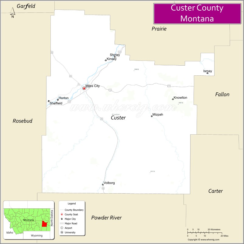
About Custer County Map, Montana: The map showing the county boundary, county seat, major cities, highways, water bodies and neighbouring counties.
Other Montana Maps & Info
Map of Custer County, Montana
Custer County is a county located in the U.S. state of Montana. It's county seat is Miles City. As per 2020 census, the population of Custer County is 11916 people and population density is square miles. According to the United States Census Bureau, the county has a total area of 3,783 sq mi (9,798 km2). Custer County was established on -12749.
Custer County Facts
| Continent | North America |
| Country | United States |
| State | Montana |
| County Seat | Miles City |
| Largest City/Town | Miles City |
| Established | 1877 |
| Total Area | 3,793 sq mi (9,824 sq km) |
| Land Area | 3,783 sq mi (9,798 sq km) |
| Water Area | 10 sq mi (26 sq km) |
| Population | 11,867 (Census 2020) |
| Population Density | 3.1 people per sq mi |
| Time Zone | Mountain Time Zone (MST/MDT) |
| Major Highways | Interstate 94, U.S. Route 12, Montana Highway 59 |
| Major Rivers | Yellowstone River, Tongue River, Powder River |
| Neighboring Counties | Prairie County, Fallon County, Powder River County, Rosebud County, Garfield County |
| Famous For | Western cattle culture, Miles City Bucking Horse Sale, and Yellowstone River history |
| Top Attractions | Range Riders Museum, Pirogue Island State Park, Miles City historic district, and Yellowstone River recreation |
| Official Website | Official Website |
About Custer County, Montana
Custer County is located in southeastern Montana in the western United States and was established in 1877. The county seat and largest city is Miles City. The county is known for its western ranching heritage, rodeo traditions, scenic river valleys, and important role in Montana’s cattle and railroad history.
Cities and Towns in Custer County, Montana
| City/Town | Population (Census 2020) | Latitude & Longitude |
|---|---|---|
| Miles City (county seat) | 8,354 | 46.4083°N, 105.8406°W |
| Ismay | 17 | 46.0436°N, 105.5366°W |
| Hathaway (CDP) | 96 | 46.7322°N, 105.6997°W |
| Kinsey (CDP) | 173 | 46.5915°N, 105.7664°W |
| Knowlton (CDP) | 11 | 45.9967°N, 105.8281°W |
| Volborg (CDP) | 32 | 45.8795°N, 105.7064°W |
Golf Courses in Custer County, Montana
| Golf Course | Location | Latitude & Longitude |
|---|---|---|
| Miles City Town & Country Club | Miles City | 46.4207°N, 105.8525°W |
| Yellowstone River Golf Recreation Area | Miles City | 46.4128°N, 105.8447°W |
Major Roads and Highways in Custer County, Montana
Major highways connect the county with eastern Montana communities and regional transportation routes.
- Interstate 94 - major east-west interstate linking Miles City with Billings and North Dakota
- U.S. Route 12 - historic highway crossing southeastern Montana prairie regions
- Montana Highway 59 - north-south route serving ranchlands and rural communities
What are the Neighboring Counties of Custer County
- Prairie County (north)
- Garfield County (northwest)
- Rosebud County (west)
- Powder River County (south)
- Fallon County (east)
What are the top Attractions in Custer County, Montana
The county offers a mix of western heritage, scenic rivers, and outdoor recreation.
- Range Riders Museum - museum dedicated to Montana ranching, frontier history, and Native American culture
- Pirogue Island State Park - riverside recreation area with hiking and wildlife viewing opportunities
- Miles City Historic District - preserved western downtown with historic architecture and local shops
- Yellowstone River Recreation Areas - scenic destinations for fishing, boating, and camping
- Miles City Bucking Horse Sale Grounds - famous rodeo and western culture event venue
- Tongue River Valley - scenic prairie river landscape with ranching heritage
- Custer County Art Center - local arts and cultural exhibitions in downtown Miles City
- Spotted Eagle Recreation Area - outdoor destination for camping and wildlife viewing
- Historic Milwaukee Railroad Sites - reminders of Miles City’s railroad history
- Southeastern Montana Scenic Drives - prairie routes featuring rolling hills and open rangeland
Distance from Custer County to Nearby Cities
The following distances are measured by road (driving).
- Miles City to Billings (Yellowstone County), Montana - 144 mi (232 km)
- Miles City to Glendive (Dawson County), Montana - 76 mi (122 km)
- Miles City to Broadus (Powder River County), Montana - 81 mi (130 km)
- Miles City to Baker (Fallon County), Montana - 82 mi (132 km)
- Miles City to Sidney (Richland County), Montana - 167 mi (269 km)
- Miles City to Ismay (Custer County), Montana - 38 mi (61 km)
- Miles City to Kinsey (Custer County), Montana - 13 mi (21 km)
- Miles City to Rapid City (Pennington County), South Dakota - 285 mi (459 km)
- Miles City to Bismarck (Burleigh County), North Dakota - 273 mi (439 km)
- Miles City to Sheridan (Sheridan County), Wyoming - 178 mi (286 km)
- Miles City to Bozeman (Gallatin County), Montana - 288 mi (463 km)
- Miles City to Denver (Denver County), Colorado - 545 mi (877 km)
- Miles City to Minneapolis (Hennepin County), Minnesota - 820 mi (1,320 km)
FAQs about Custer County
Custer County is located in southeastern Montana along the Yellowstone River.
Custer County had a population of 11,867 according to the 2020 United States Census.
Custer County is known for western cattle culture, the Miles City Bucking Horse Sale, and Yellowstone River history.
The county is served by Interstate 94, U.S. Route 12, and Montana Highway 59.
Yes, Custer County includes golf facilities such as Miles City Town & Country Club and recreation golf areas near the Yellowstone River.
References
- QuickFacts - U.S. Census Bureau
- United States Census Bureau
- United States Geological Survey (USGS)
- National Geodetic Survey
- Official Website
- Beaverhead County Map
- Big Horn County Map
- Blaine County Map
- Broadwater County Map
- Carbon County Map
- Carter County Map
- Cascade County Map
- Chouteau County Map
- Custer County Map
- Daniels County Map
- Dawson County Map
- Deer Lodge County Map
- Fallon County Map
- Fergus County Map
- Flathead County Map
- Gallatin County Map
- Garfield County Map
- Glacier County Map
- Golden Valley County Map
- Granite County Map
- Hill County Map
- Jefferson County Map
- Judith Basin County Map
- Lake County Map
- Lewis and Clark County Map
- Liberty County Map
- Lincoln County Map
- McCone County Map
- Madison County Map
- Meagher County Map
- Mineral County Map
- Missoula County Map
- Musselshell County Map
- Park County Map
- Petroleum County Map
- Phillips County Map
- Pondera County Map
- Powder River County Map
- Powell County Map
- Prairie County Map
- Ravalli County Map
- Richland County Map
- Roosevelt County Map
- Rosebud County Map
- Sanders County Map
- Sheridan County Map
- Silver Bow County Map
- Stillwater County Map
- Sweet Grass County Map
- Teton County Map
- Toole County Map
- Treasure County Map
- Valley County Map
- Wheatland County Map
- Wibaux County Map
- Yellowstone County Map
- Alabama Counties
- Alaska boroughs
- Arizona Counties
- Arkansas Counties
- California County Map
- Colorado Counties
- Connecticut Counties
- Delaware Counties
- Florida County Map
- Georgia County Map
- Hawaii Counties
- Idaho Counties
- Illinois Counties
- Indiana Counties
- Iowa Counties
- Kansas Counties
- Kentucky Counties
- Louisiana Counties
- Maine Counties
- Maryland Counties
- Massachusetts Counties
- Michigan County Map
- Minnesota Counties
- Mississippi Counties
- Missouri Counties
- Montana Counties
- Nebraska Counties
- Nevada Counties
- New York Counties
- New Hampshire Counties
- New Jersey Counties
- New Mexico Counties
- North Carolina Counties
- North Dakota Counties
- Ohio County Map
- Oklahoma Counties
- Oregon Counties
- Pennsylvania Counties
- Rhode Island Counties
- South Carolina Counties
- South Dakota Counties
- Map of Tennessee
- Texas County Map
- Utah Counties
- Vermont Counties
- Virginia Counties
- Washington Counties
- West Virginia Counties
- Wisconsin Counties
- Wyoming Counties