Map of Deer Lodge County - Deer Lodge County is a county located in the U.S. state of Montana. Deer Lodge County Map showing cities, highways, important places and water bodies. Get Where is Deer Lodge County located in the map, major cities in Deer Lodge county, population, areas, and places of interest.
Map of Deer Lodge County, Montana
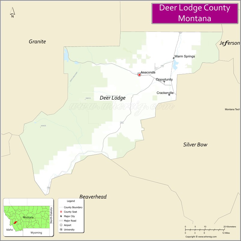
About Deer Lodge County Map, Montana: The map showing the county boundary, county seat, major cities, highways, water bodies and neighbouring counties.
Other Montana Maps & Info
Map of Deer Lodge County, Montana
Deer Lodge County is a county located in the U.S. state of Montana. It's county seat is Anaconda. As per 2020 census, the population of Deer Lodge County is 9491 people and population density is square miles. According to the United States Census Bureau, the county has a total area of 737 sq mi (1,909 km2). Deer Lodge County was established on -12749.
Deer Lodge County Facts
| Continent | North America |
| Country | United States |
| State | Montana |
| County Seat | Anaconda |
| Largest City/Town | Anaconda |
| Established | 1881 |
| Total Area | 741 sq mi (1,919 sq km) |
| Land Area | 737 sq mi (1,909 sq km) |
| Water Area | 4 sq mi (10 sq km) |
| Population | 9,421 (Census 2020) |
| Population Density | 12.8 people per sq mi |
| Time Zone | Mountain Time Zone (MST/MDT) |
| Major Highways | Interstate 90, Montana Highway 1, Montana Highway 48 |
| Major Rivers | Clark Fork River |
| Neighboring Counties | Silver Bow County, Powell County, Granite County, Jefferson County |
| Famous For | Anaconda copper mining history, Georgetown Lake, and mountain recreation |
| Top Attractions | Old Works Golf Course, Georgetown Lake, Anaconda Smoke Stack State Park, and Discovery Ski Area |
| Official Website | Official Website |
About Deer Lodge County, Montana
Deer Lodge County is located in southwestern Montana in the western United States and was established in 1881. The county seat and largest city is Anaconda. The county is known for its historic copper mining industry, scenic mountain landscapes, outdoor recreation, and rich industrial heritage in the Rocky Mountains.
Cities and Towns in Deer Lodge County, Montana
| City/Town | Population (Census 2020) | Latitude & Longitude |
|---|---|---|
| Anaconda (county seat) | 9,153 | 46.1285°N, 112.9428°W |
| Warm Springs (CDP) | 1,021 | 46.1836°N, 112.7851°W |
| Opportunity (CDP) | 1,064 | 46.1219°N, 112.7997°W |
| Fairmont (CDP) | 128 | 46.0456°N, 112.8124°W |
| Ramsay (Nearby Community) | 39 | 46.0328°N, 112.7392°W |
| Georgetown Lake Area (Resort Community) | 214 | 46.1921°N, 113.2875°W |
Golf Courses in Deer Lodge County, Montana
| Golf Course | Location | Latitude & Longitude |
|---|---|---|
| Old Works Golf Course | Anaconda | 46.1298°N, 112.9483°W |
| Georgetown Lake Golf Recreation Area | Georgetown Lake | 46.1972°N, 113.2928°W |
Major Roads and Highways in Deer Lodge County, Montana
Major highways connect the county with western Montana cities and scenic mountain destinations.
- Interstate 90 - major east-west interstate linking Anaconda with Butte and Missoula
- Montana Highway 1 - scenic Pintler Veterans Memorial Scenic Highway through mountain landscapes
- Montana Highway 48 - local connector route serving Anaconda and surrounding communities
What are the Neighboring Counties of Deer Lodge County
- Silver Bow County (south)
- Jefferson County (east)
- Powell County (north)
- Granite County (west)
What are the top Attractions in Deer Lodge County, Montana
The county offers a mix of historic mining landmarks and outdoor recreation attractions.
- Old Works Golf Course - nationally recognized golf course designed by Jack Nicklaus on a former smelter site
- Georgetown Lake - popular recreation lake for boating, fishing, and camping
- Anaconda Smoke Stack State Park - historic industrial landmark featuring one of the world’s tallest brick smokestacks
- Discovery Ski Area - mountain ski resort offering winter sports and summer recreation
- Washoe Theater - historic Art Deco theater in downtown Anaconda
- Pintler Scenic Highway - scenic mountain drive through forests and alpine landscapes
- Fairmont Hot Springs Resort nearby region - hot springs and family recreation destination
- Lost Creek State Park - natural recreation area with waterfalls and hiking trails
- Downtown Anaconda Historic District - preserved mining-era architecture and local shops
- Mount Haggin Wildlife Management Area - wildlife viewing, hiking, and outdoor recreation opportunities
Distance from Deer Lodge County to Nearby Cities
The following distances are measured by road (driving).
- Anaconda to Butte (Silver Bow County), Montana - 26 mi (42 km)
- Anaconda to Missoula (Missoula County), Montana - 108 mi (174 km)
- Anaconda to Helena (Lewis and Clark County), Montana - 92 mi (148 km)
- Anaconda to Bozeman (Gallatin County), Montana - 105 mi (169 km)
- Anaconda to Georgetown Lake (Deer Lodge County), Montana - 18 mi (29 km)
- Anaconda to Warm Springs (Deer Lodge County), Montana - 9 mi (14 km)
- Anaconda to Philipsburg (Granite County), Montana - 33 mi (53 km)
- Anaconda to Dillon (Beaverhead County), Montana - 81 mi (130 km)
- Anaconda to Great Falls (Cascade County), Montana - 177 mi (285 km)
- Anaconda to Kalispell (Flathead County), Montana - 237 mi (381 km)
- Anaconda to Spokane (Spokane County), Washington - 318 mi (512 km)
- Anaconda to Salt Lake City (Salt Lake County), Utah - 467 mi (752 km)
- Anaconda to Denver (Denver County), Colorado - 708 mi (1,139 km)
FAQs about Deer Lodge County
Deer Lodge County is located in southwestern Montana in the Rocky Mountain region.
Deer Lodge County had a population of 9,421 according to the 2020 United States Census.
Deer Lodge County is known for Anaconda’s copper mining history, Georgetown Lake, and mountain recreation.
The county is served by Interstate 90, Montana Highway 1, and Montana Highway 48.
Yes, Deer Lodge County includes golf facilities such as Old Works Golf Course and recreation golf areas near Georgetown Lake.
References
- QuickFacts - U.S. Census Bureau
- United States Census Bureau
- United States Geological Survey (USGS)
- National Geodetic Survey
- Official Website
- Beaverhead County Map
- Big Horn County Map
- Blaine County Map
- Broadwater County Map
- Carbon County Map
- Carter County Map
- Cascade County Map
- Chouteau County Map
- Custer County Map
- Daniels County Map
- Dawson County Map
- Deer Lodge County Map
- Fallon County Map
- Fergus County Map
- Flathead County Map
- Gallatin County Map
- Garfield County Map
- Glacier County Map
- Golden Valley County Map
- Granite County Map
- Hill County Map
- Jefferson County Map
- Judith Basin County Map
- Lake County Map
- Lewis and Clark County Map
- Liberty County Map
- Lincoln County Map
- McCone County Map
- Madison County Map
- Meagher County Map
- Mineral County Map
- Missoula County Map
- Musselshell County Map
- Park County Map
- Petroleum County Map
- Phillips County Map
- Pondera County Map
- Powder River County Map
- Powell County Map
- Prairie County Map
- Ravalli County Map
- Richland County Map
- Roosevelt County Map
- Rosebud County Map
- Sanders County Map
- Sheridan County Map
- Silver Bow County Map
- Stillwater County Map
- Sweet Grass County Map
- Teton County Map
- Toole County Map
- Treasure County Map
- Valley County Map
- Wheatland County Map
- Wibaux County Map
- Yellowstone County Map
- Alabama Counties
- Alaska boroughs
- Arizona Counties
- Arkansas Counties
- California County Map
- Colorado Counties
- Connecticut Counties
- Delaware Counties
- Florida County Map
- Georgia County Map
- Hawaii Counties
- Idaho Counties
- Illinois Counties
- Indiana Counties
- Iowa Counties
- Kansas Counties
- Kentucky Counties
- Louisiana Counties
- Maine Counties
- Maryland Counties
- Massachusetts Counties
- Michigan County Map
- Minnesota Counties
- Mississippi Counties
- Missouri Counties
- Montana Counties
- Nebraska Counties
- Nevada Counties
- New York Counties
- New Hampshire Counties
- New Jersey Counties
- New Mexico Counties
- North Carolina Counties
- North Dakota Counties
- Ohio County Map
- Oklahoma Counties
- Oregon Counties
- Pennsylvania Counties
- Rhode Island Counties
- South Carolina Counties
- South Dakota Counties
- Map of Tennessee
- Texas County Map
- Utah Counties
- Vermont Counties
- Virginia Counties
- Washington Counties
- West Virginia Counties
- Wisconsin Counties
- Wyoming Counties