Map of Beaverhead County - Beaverhead County is a county located in the U.S. state of Montana. Beaverhead County Map showing cities, highways, important places and water bodies. Get Where is Beaverhead County located in the map, major cities in Beaverhead county, population, areas, and places of interest.
Map of Beaverhead County, Montana
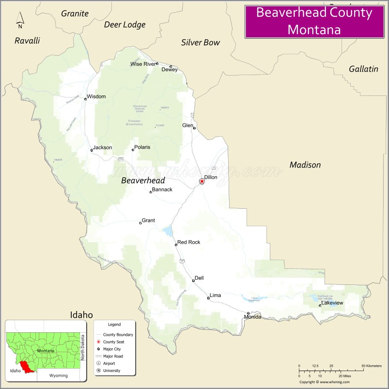
About Beaverhead County Map, Montana: The map showing the county boundary, county seat, major cities, highways, water bodies and neighbouring counties.
Other Montana Maps & Info
Map of Beaverhead County, Montana
Beaverhead County is a county located in the U.S. state of Montana. It's county seat is Dillon. As per 2020 census, the population of Beaverhead County is 9524 people and population density is square miles. According to the United States Census Bureau, the county has a total area of 5,543 sq mi (14,356 km2). Beaverhead County was established on -12749.
Beaverhead County Facts
| Continent | North America |
| Country | United States |
| State | Montana |
| County Seat | Dillon |
| Largest City/Town | Dillon |
| Established | 1865 |
| Total Area | 5,572 sq mi (14,431 sq km) |
| Land Area | 5,542 sq mi (14,354 sq km) |
| Water Area | 30 sq mi (78 sq km) |
| Population | 9,371 (Census 2020) |
| Population Density | 1.7 people per sq mi |
| Time Zone | Mountain Time Zone (MST/MDT) |
| Major Highways | Interstate 15, Montana Highway 41, Montana Highway 278 |
| Major Rivers | Beaverhead River, Big Hole River, Red Rock River |
| Neighboring Counties | Madison County, Silver Bow County, Deer Lodge County, Ravalli County, Lemhi County (ID), Clark County (ID) |
| Famous For | Fly fishing, Lewis and Clark history, ranching, and scenic mountain landscapes |
| Top Attractions | Bannack State Park, Beaverhead River, Big Hole Valley, and Clark Canyon Reservoir |
| Official Website | Official Website |
About Beaverhead County, Montana
Beaverhead County is located in southwestern Montana in the western United States and was established in 1865. The county seat and largest city is Dillon. The county is known for its expansive mountain scenery, world-class fly fishing rivers, historic mining towns, and ranching heritage in the Northern Rockies.
Cities and Towns in Beaverhead County, Montana
| City/Town | Population (Census 2020) | Latitude & Longitude |
|---|---|---|
| Dillon (county seat) | 4,098 | 45.2166°N, 112.6375°W |
| Lima | 221 | 44.6358°N, 112.5925°W |
| Wisdom (CDP) | 98 | 45.6178°N, 113.4487°W |
| Jackson (CDP) | 39 | 45.3745°N, 113.3631°W |
| Grant (CDP) | 91 | 45.4482°N, 113.3778°W |
| Polaris (CDP) | 115 | 45.4356°N, 113.3102°W |
Golf Courses in Beaverhead County, Montana
| Golf Course | Location | Latitude & Longitude |
|---|---|---|
| Beaverhead Golf Course | Dillon | 45.2234°N, 112.6408°W |
| Big Sky Golf Recreation Area | Dillon | 45.2101°N, 112.6315°W |
Major Roads and Highways in Beaverhead County, Montana
Major highways connect the county with Montana, Idaho, and Rocky Mountain recreation areas.
- Interstate 15 - major north-south interstate linking Dillon with Butte and Idaho Falls
- Montana Highway 41 - scenic highway connecting Dillon with Twin Bridges and Silver Star
- Montana Highway 278 - regional route through ranchlands and mountain valleys
What are the Neighboring Counties of Beaverhead County
- Silver Bow County (north)
- Deer Lodge County (northwest)
- Madison County (east)
- Ravalli County (west)
- Lemhi County, Idaho (southwest)
- Clark County, Idaho (south)
What are the top Attractions in Beaverhead County, Montana
The county offers a mix of historic, scenic, and outdoor recreation attractions.
- Bannack State Park - preserved ghost town and former Montana territorial capital
- Beaverhead River - nationally known fly fishing river with scenic landscapes
- Big Hole Valley - picturesque valley famous for ranching and mountain views
- Clark Canyon Reservoir - popular destination for boating, fishing, and camping
- Lewis and Clark Historic Areas - sites connected to the Lewis and Clark Expedition
- Beaverhead-Deerlodge National Forest - expansive forest with hiking and wildlife opportunities
- Elkhorn Hot Springs - rustic mountain hot springs resort near Polaris
- Downtown Dillon Historic District - historic western architecture and local shops
- Red Rock Lakes National Wildlife Refuge - wildlife viewing and birdwatching area
- Pioneer Mountains Scenic Byway - scenic driving route through the Rocky Mountains
Distance from Beaverhead County to Nearby Cities
The following distances are measured by road (driving).
- Dillon to Butte (Silver Bow County), Montana - 66 mi (106 km)
- Dillon to Bozeman (Gallatin County), Montana - 125 mi (201 km)
- Dillon to Idaho Falls (Bonneville County), Idaho - 113 mi (182 km)
- Dillon to Missoula (Missoula County), Montana - 171 mi (275 km)
- Dillon to Helena (Lewis and Clark County), Montana - 127 mi (204 km)
- Dillon to Lima (Beaverhead County), Montana - 45 mi (72 km)
- Dillon to Wisdom (Beaverhead County), Montana - 70 mi (113 km)
- Dillon to Jackson (Beaverhead County), Montana - 57 mi (92 km)
- Dillon to Twin Bridges (Madison County), Montana - 41 mi (66 km)
- Dillon to Salmon (Lemhi County), Idaho - 108 mi (174 km)
- Dillon to Ennis (Madison County), Montana - 74 mi (119 km)
- Dillon to Billings (Yellowstone County), Montana - 273 mi (439 km)
- Dillon to Salt Lake City (Salt Lake County), Utah - 387 mi (623 km)
FAQs about Beaverhead County
Beaverhead County is located in southwestern Montana near the Idaho border.
Beaverhead County had a population of 9,371 according to the 2020 United States Census.
Beaverhead County is known for fly fishing, ranching, mountain scenery, and the historic ghost town of Bannack.
The county is served by Interstate 15, Montana Highway 41, and Montana Highway 278.
Yes, Beaverhead County includes golf facilities such as Beaverhead Golf Course and recreation golf areas in Dillon.
References
- QuickFacts - U.S. Census Bureau
- United States Census Bureau
- United States Geological Survey (USGS)
- National Geodetic Survey
- Official Website
- Beaverhead County Map
- Big Horn County Map
- Blaine County Map
- Broadwater County Map
- Carbon County Map
- Carter County Map
- Cascade County Map
- Chouteau County Map
- Custer County Map
- Daniels County Map
- Dawson County Map
- Deer Lodge County Map
- Fallon County Map
- Fergus County Map
- Flathead County Map
- Gallatin County Map
- Garfield County Map
- Glacier County Map
- Golden Valley County Map
- Granite County Map
- Hill County Map
- Jefferson County Map
- Judith Basin County Map
- Lake County Map
- Lewis and Clark County Map
- Liberty County Map
- Lincoln County Map
- McCone County Map
- Madison County Map
- Meagher County Map
- Mineral County Map
- Missoula County Map
- Musselshell County Map
- Park County Map
- Petroleum County Map
- Phillips County Map
- Pondera County Map
- Powder River County Map
- Powell County Map
- Prairie County Map
- Ravalli County Map
- Richland County Map
- Roosevelt County Map
- Rosebud County Map
- Sanders County Map
- Sheridan County Map
- Silver Bow County Map
- Stillwater County Map
- Sweet Grass County Map
- Teton County Map
- Toole County Map
- Treasure County Map
- Valley County Map
- Wheatland County Map
- Wibaux County Map
- Yellowstone County Map
- Alabama Counties
- Alaska boroughs
- Arizona Counties
- Arkansas Counties
- California County Map
- Colorado Counties
- Connecticut Counties
- Delaware Counties
- Florida County Map
- Georgia County Map
- Hawaii Counties
- Idaho Counties
- Illinois Counties
- Indiana Counties
- Iowa Counties
- Kansas Counties
- Kentucky Counties
- Louisiana Counties
- Maine Counties
- Maryland Counties
- Massachusetts Counties
- Michigan County Map
- Minnesota Counties
- Mississippi Counties
- Missouri Counties
- Montana Counties
- Nebraska Counties
- Nevada Counties
- New York Counties
- New Hampshire Counties
- New Jersey Counties
- New Mexico Counties
- North Carolina Counties
- North Dakota Counties
- Ohio County Map
- Oklahoma Counties
- Oregon Counties
- Pennsylvania Counties
- Rhode Island Counties
- South Carolina Counties
- South Dakota Counties
- Map of Tennessee
- Texas County Map
- Utah Counties
- Vermont Counties
- Virginia Counties
- Washington Counties
- West Virginia Counties
- Wisconsin Counties
- Wyoming Counties