Map of Liberty County - Liberty County is a county located in the U.S. state of Montana. Liberty County Map showing cities, highways, important places and water bodies. Get Where is Liberty County located in the map, major cities in Liberty county, population, areas, and places of interest.
Map of Liberty County, Montana
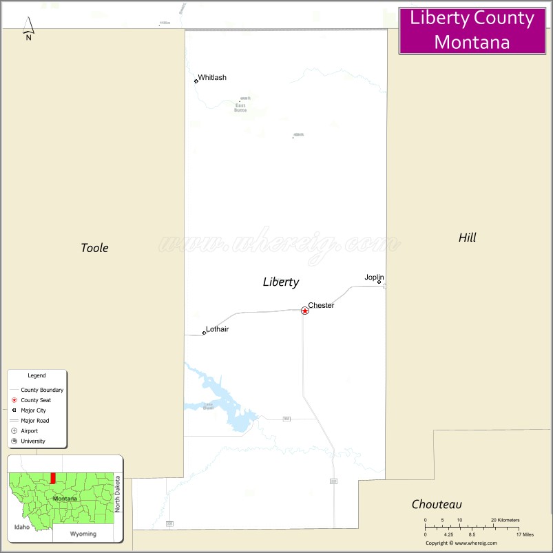
About Liberty County Map, Montana: The map showing the county boundary, county seat, major cities, highways, water bodies and neighbouring counties.
Other Montana Maps & Info
Map of Liberty County, Montana
Liberty County is a county located in the U.S. state of Montana. It's county seat is Chester. As per 2020 census, the population of Liberty County is 1946 people and population density is square miles. According to the United States Census Bureau, the county has a total area of 1,430 sq mi (3,704 km2). Liberty County was established on 7347.
Liberty County Facts
| Continent | North America |
| Country | United States |
| State | Montana |
| County Seat | Chester |
| Largest City/Town | Chester |
| Established | 1920 |
| Total Area | 1,447 sq mi (3,748 sq km) |
| Land Area | 1,430 sq mi (3,704 sq km) |
| Water Area | 17 sq mi (44 sq km) |
| Population | 2,095 (Census 2020) |
| Population Density | 1.5 people per sq mi |
| Time Zone | Mountain Time Zone (MST/MDT) |
| Major Highways | U.S. Route 2, Montana Highway 224 |
| Major Rivers | Marias River, Tiber Reservoir tributaries |
| Neighboring Counties | Hill County, Chouteau County, Toole County |
| Famous For | Wheat farming, prairie landscapes, and northern Montana railroad communities |
| Top Attractions | Tiber Reservoir nearby region, Liberty County Museum, prairie scenic drives, and Marias River recreation |
| Official Website | Official Website |
About Liberty County, Montana
Liberty County is located in north-central Montana in the western United States and was established in 1920. The county seat and largest town is Chester. The county is known for its expansive wheat fields, rural prairie landscapes, railroad history, and strong agricultural traditions across northern Montana.
Cities and Towns in Liberty County, Montana
| City/Town | Population (Census 2020) | Latitude & Longitude |
|---|---|---|
| Chester (county seat) | 847 | 48.5100°N, 110.9705°W |
| Joplin | 210 | 48.5591°N, 110.7663°W |
| Rudyard | 289 | 48.5583°N, 110.5581°W |
| Whitlash (Rural Community) | 57 | 48.9055°N, 111.0792°W |
| Inverness (CDP) | 94 | 48.5531°N, 110.4018°W |
| Loring (Rural Community) | 35 | 48.6342°N, 111.0013°W |
Golf Courses in Liberty County, Montana
| Golf Course | Location | Latitude & Longitude |
|---|---|---|
| Chester Golf Club | Chester | 48.5158°N, 110.9774°W |
| Liberty Prairie Golf Recreation Area | Joplin | 48.5630°N, 110.7718°W |
Major Roads and Highways in Liberty County, Montana
Major highways connect the county with northern Montana agricultural and railroad communities.
- U.S. Route 2 - major east-west highway and rail corridor across northern Montana
- Montana Highway 224 - regional highway serving local prairie communities and agricultural areas
What are the Neighboring Counties of Liberty County
- Toole County (northwest)
- Hill County (east)
- Chouteau County (south)
What are the top Attractions in Liberty County, Montana
The county offers a mix of prairie scenery, agricultural heritage, and outdoor recreation.
- Tiber Reservoir nearby region - boating, fishing, and camping recreation destination
- Liberty County Museum - local museum featuring railroad, farming, and pioneer history
- Prairie Scenic Drives - countryside routes through rolling wheat fields and open plains
- Marias River Recreation Areas - fishing and wildlife viewing destinations
- Chester Historic Downtown - small-town district with historic architecture and local businesses
- Whitlash Countryside Views - scenic northern Montana prairie landscapes near the Canadian border
- Hi-Line Railroad Heritage Sites - historic railroad corridor attractions across northern Montana
- Joplin Agricultural Community Sites - farming and ranching heritage attractions
- Wildlife Observation Areas - habitats for antelope, deer, and migratory birds
- Golden Triangle Farming Region - one of Montana’s major wheat-producing agricultural areas
Distance from Liberty County to Nearby Cities
The following distances are measured by road (driving).
- Chester to Havre (Hill County), Montana - 54 mi (87 km)
- Chester to Shelby (Toole County), Montana - 64 mi (103 km)
- Chester to Great Falls (Cascade County), Montana - 118 mi (190 km)
- Chester to Cut Bank (Glacier County), Montana - 96 mi (154 km)
- Chester to Billings (Yellowstone County), Montana - 279 mi (449 km)
- Chester to Joplin (Liberty County), Montana - 7 mi (11 km)
- Chester to Rudyard (Liberty County), Montana - 23 mi (37 km)
- Chester to Helena (Lewis and Clark County), Montana - 209 mi (336 km)
- Chester to Kalispell (Flathead County), Montana - 216 mi (348 km)
- Chester to Bozeman (Gallatin County), Montana - 302 mi (486 km)
- Chester to Calgary, Alberta - 216 mi (348 km)
- Chester to Regina, Saskatchewan - 279 mi (449 km)
- Chester to Spokane (Spokane County), Washington - 470 mi (756 km)
FAQs about Liberty County
Liberty County is located in north-central Montana near the Canadian border.
Liberty County had a population of 2,095 according to the 2020 United States Census.
Liberty County is known for wheat farming, prairie scenery, and northern Montana railroad communities.
The county is served by U.S. Route 2 and Montana Highway 224.
Yes, Liberty County includes golf facilities such as Chester Golf Club and prairie recreation golf areas near Joplin.
References
- QuickFacts - U.S. Census Bureau
- United States Census Bureau
- United States Geological Survey (USGS)
- National Geodetic Survey
- Official Website
- Beaverhead County Map
- Big Horn County Map
- Blaine County Map
- Broadwater County Map
- Carbon County Map
- Carter County Map
- Cascade County Map
- Chouteau County Map
- Custer County Map
- Daniels County Map
- Dawson County Map
- Deer Lodge County Map
- Fallon County Map
- Fergus County Map
- Flathead County Map
- Gallatin County Map
- Garfield County Map
- Glacier County Map
- Golden Valley County Map
- Granite County Map
- Hill County Map
- Jefferson County Map
- Judith Basin County Map
- Lake County Map
- Lewis and Clark County Map
- Liberty County Map
- Lincoln County Map
- McCone County Map
- Madison County Map
- Meagher County Map
- Mineral County Map
- Missoula County Map
- Musselshell County Map
- Park County Map
- Petroleum County Map
- Phillips County Map
- Pondera County Map
- Powder River County Map
- Powell County Map
- Prairie County Map
- Ravalli County Map
- Richland County Map
- Roosevelt County Map
- Rosebud County Map
- Sanders County Map
- Sheridan County Map
- Silver Bow County Map
- Stillwater County Map
- Sweet Grass County Map
- Teton County Map
- Toole County Map
- Treasure County Map
- Valley County Map
- Wheatland County Map
- Wibaux County Map
- Yellowstone County Map
- Alabama Counties
- Alaska boroughs
- Arizona Counties
- Arkansas Counties
- California County Map
- Colorado Counties
- Connecticut Counties
- Delaware Counties
- Florida County Map
- Georgia County Map
- Hawaii Counties
- Idaho Counties
- Illinois Counties
- Indiana Counties
- Iowa Counties
- Kansas Counties
- Kentucky Counties
- Louisiana Counties
- Maine Counties
- Maryland Counties
- Massachusetts Counties
- Michigan County Map
- Minnesota Counties
- Mississippi Counties
- Missouri Counties
- Montana Counties
- Nebraska Counties
- Nevada Counties
- New York Counties
- New Hampshire Counties
- New Jersey Counties
- New Mexico Counties
- North Carolina Counties
- North Dakota Counties
- Ohio County Map
- Oklahoma Counties
- Oregon Counties
- Pennsylvania Counties
- Rhode Island Counties
- South Carolina Counties
- South Dakota Counties
- Map of Tennessee
- Texas County Map
- Utah Counties
- Vermont Counties
- Virginia Counties
- Washington Counties
- West Virginia Counties
- Wisconsin Counties
- Wyoming Counties