Map of Carbon County - Carbon County is a county located in the U.S. state of Montana. Carbon County Map showing cities, highways, important places and water bodies. Get Where is Carbon County located in the map, major cities in Carbon county, population, areas, and places of interest.
Map of Carbon County, Montana
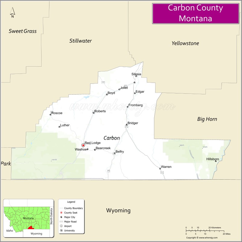
About Carbon County Map, Montana: The map showing the county boundary, county seat, major cities, highways, water bodies and neighbouring counties.
Other Montana Maps & Info
Map of Carbon County, Montana
Carbon County is a county located in the U.S. state of Montana. It's county seat is Red Lodge. As per 2020 census, the population of Carbon County is 10847 people and population density is square miles. According to the United States Census Bureau, the county has a total area of 2,048 sq mi (5,304 km2). Carbon County was established on -1762.
Carbon County Facts
| Continent | North America |
| Country | United States |
| State | Montana |
| County Seat | Red Lodge |
| Largest City/Town | Red Lodge |
| Established | 1895 |
| Total Area | 2,062 sq mi (5,341 sq km) |
| Land Area | 2,049 sq mi (5,307 sq km) |
| Water Area | 13 sq mi (34 sq km) |
| Population | 10,453 (Census 2020) |
| Population Density | 5.1 people per sq mi |
| Time Zone | Mountain Time Zone (MST/MDT) |
| Major Highways | U.S. Route 212, Montana Highway 78, Beartooth Highway |
| Major Rivers | Clarks Fork Yellowstone River, Rock Creek |
| Neighboring Counties | Stillwater County, Yellowstone County, Big Horn County, Park County (WY) |
| Famous For | Beartooth Highway, Red Lodge Mountain, and scenic Rocky Mountain landscapes |
| Top Attractions | Beartooth Highway, Red Lodge Mountain, Yellowstone gateway routes, and Carbon County Historical Museum |
| Official Website | Official Website |
About Carbon County, Montana
Carbon County is located in south-central Montana in the western United States and was established in 1895. The county seat and largest city is Red Lodge. The county is known for its mountain scenery, outdoor recreation, historic mining heritage, and as a gateway to Yellowstone National Park through the famous Beartooth Highway.
Cities and Towns in Carbon County, Montana
| City/Town | Population (Census 2020) | Latitude & Longitude |
|---|---|---|
| Red Lodge (county seat) | 2,257 | 45.1858°N, 109.2465°W |
| Bridger | 708 | 45.2966°N, 108.9146°W |
| Joliet | 639 | 45.4857°N, 108.9735°W |
| Fromberg | 428 | 45.3921°N, 108.8956°W |
| Bearcreek | 77 | 45.1622°N, 109.0439°W |
| Roberts (CDP) | 294 | 45.4083°N, 109.1714°W |
Golf Courses in Carbon County, Montana
| Golf Course | Location | Latitude & Longitude |
|---|---|---|
| Red Lodge Mountain Golf Course | Red Lodge | 45.1879°N, 109.2528°W |
| Bridger Creek Golf Recreation Area | Bridger | 45.3001°N, 108.9204°W |
Major Roads and Highways in Carbon County, Montana
Major highways connect the county with Yellowstone National Park and southern Montana communities.
- U.S. Route 212 - scenic highway connecting Red Lodge with Billings and Yellowstone National Park
- Montana Highway 78 - route linking Red Lodge with Columbus and Interstate 90
- Beartooth Highway - nationally recognized scenic byway through the Beartooth Mountains
What are the Neighboring Counties of Carbon County
- Stillwater County (northwest)
- Yellowstone County (north)
- Big Horn County (east)
- Park County, Wyoming (south)
What are the top Attractions in Carbon County, Montana
The county offers a mix of mountain recreation, scenic drives, and historic attractions.
- Beartooth Highway - famous scenic mountain highway leading toward Yellowstone National Park
- Red Lodge Mountain - ski resort offering winter sports and summer recreation
- Carbon County Historical Museum - museum featuring mining, ranching, and local frontier history
- Custer Gallatin National Forest - expansive forest with hiking, camping, and wildlife viewing
- Rock Creek Recreation Area - popular fishing and outdoor recreation destination
- Downtown Red Lodge Historic District - charming mountain town with shops, restaurants, and historic buildings
- Yellowstone Wildlife Scenic Routes - scenic drives featuring mountain and wildlife landscapes
- Bearcreek Historic Mining Town - former coal mining community with local history attractions
- Lake Fork Trail System - hiking and nature trails in the Beartooth Mountains
- Clarks Fork Yellowstone River - scenic river corridor for fishing and rafting activities
Distance from Carbon County to Nearby Cities
The following distances are measured by road (driving).
- Red Lodge to Billings (Yellowstone County), Montana - 62 mi (100 km)
- Red Lodge to Cody (Park County), Wyoming - 62 mi (100 km)
- Red Lodge to Bozeman (Gallatin County), Montana - 145 mi (233 km)
- Red Lodge to Yellowstone National Park (Northeast Entrance) - 68 mi (109 km)
- Red Lodge to Bridger (Carbon County), Montana - 30 mi (48 km)
- Red Lodge to Joliet (Carbon County), Montana - 47 mi (76 km)
- Red Lodge to Fromberg (Carbon County), Montana - 40 mi (64 km)
- Red Lodge to Sheridan (Sheridan County), Wyoming - 116 mi (187 km)
- Red Lodge to Livingston (Park County), Montana - 96 mi (154 km)
- Red Lodge to Helena (Lewis and Clark County), Montana - 205 mi (330 km)
- Red Lodge to Missoula (Missoula County), Montana - 333 mi (536 km)
- Red Lodge to Rapid City (Pennington County), South Dakota - 343 mi (552 km)
- Red Lodge to Denver (Denver County), Colorado - 505 mi (813 km)
FAQs about Carbon County
Carbon County is located in south-central Montana near the Wyoming border.
Carbon County had a population of 10,453 according to the 2020 United States Census.
Carbon County is known for the Beartooth Highway, Red Lodge Mountain, and scenic Rocky Mountain landscapes.
The county is served by U.S. Route 212, Montana Highway 78, and the Beartooth Highway.
Yes, Carbon County includes golf facilities such as Red Lodge Mountain Golf Course and recreation golf areas near Bridger.
References
- QuickFacts - U.S. Census Bureau
- United States Census Bureau
- United States Geological Survey (USGS)
- National Geodetic Survey
- Official Website
- Beaverhead County Map
- Big Horn County Map
- Blaine County Map
- Broadwater County Map
- Carbon County Map
- Carter County Map
- Cascade County Map
- Chouteau County Map
- Custer County Map
- Daniels County Map
- Dawson County Map
- Deer Lodge County Map
- Fallon County Map
- Fergus County Map
- Flathead County Map
- Gallatin County Map
- Garfield County Map
- Glacier County Map
- Golden Valley County Map
- Granite County Map
- Hill County Map
- Jefferson County Map
- Judith Basin County Map
- Lake County Map
- Lewis and Clark County Map
- Liberty County Map
- Lincoln County Map
- McCone County Map
- Madison County Map
- Meagher County Map
- Mineral County Map
- Missoula County Map
- Musselshell County Map
- Park County Map
- Petroleum County Map
- Phillips County Map
- Pondera County Map
- Powder River County Map
- Powell County Map
- Prairie County Map
- Ravalli County Map
- Richland County Map
- Roosevelt County Map
- Rosebud County Map
- Sanders County Map
- Sheridan County Map
- Silver Bow County Map
- Stillwater County Map
- Sweet Grass County Map
- Teton County Map
- Toole County Map
- Treasure County Map
- Valley County Map
- Wheatland County Map
- Wibaux County Map
- Yellowstone County Map
- Alabama Counties
- Alaska boroughs
- Arizona Counties
- Arkansas Counties
- California County Map
- Colorado Counties
- Connecticut Counties
- Delaware Counties
- Florida County Map
- Georgia County Map
- Hawaii Counties
- Idaho Counties
- Illinois Counties
- Indiana Counties
- Iowa Counties
- Kansas Counties
- Kentucky Counties
- Louisiana Counties
- Maine Counties
- Maryland Counties
- Massachusetts Counties
- Michigan County Map
- Minnesota Counties
- Mississippi Counties
- Missouri Counties
- Montana Counties
- Nebraska Counties
- Nevada Counties
- New York Counties
- New Hampshire Counties
- New Jersey Counties
- New Mexico Counties
- North Carolina Counties
- North Dakota Counties
- Ohio County Map
- Oklahoma Counties
- Oregon Counties
- Pennsylvania Counties
- Rhode Island Counties
- South Carolina Counties
- South Dakota Counties
- Map of Tennessee
- Texas County Map
- Utah Counties
- Vermont Counties
- Virginia Counties
- Washington Counties
- West Virginia Counties
- Wisconsin Counties
- Wyoming Counties