Map of Big Horn County - Big Horn County is a county located in the U.S. state of Montana. Big Horn County Map showing cities, highways, important places and water bodies. Get Where is Big Horn County located in the map, major cities in Big Horn county, population, areas, and places of interest.
Map of Big Horn County, Montana
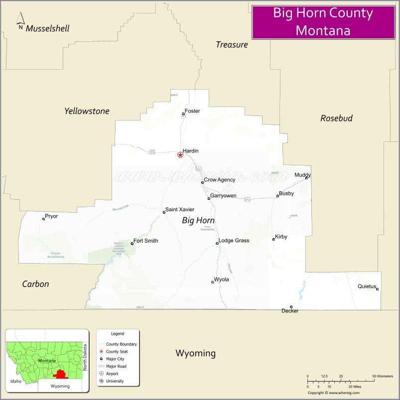
About Big Horn County Map, Montana: The map showing the county boundary, county seat, major cities, highways, water bodies and neighbouring counties.
Other Montana Maps & Info
Map of Big Horn County, Montana
Big Horn County is a county located in the U.S. state of Montana. It's county seat is Hardin. As per 2020 census, the population of Big Horn County is 12957 people and population density is square miles. According to the United States Census Bureau, the county has a total area of 4,995 sq mi (12,937 km2). Big Horn County was established on 4762.
Big Horn County Facts
| Continent | North America |
| Country | United States |
| State | Montana |
| County Seat | Hardin |
| Largest City/Town | Hardin |
| Established | 1913 |
| Total Area | 5,015 sq mi (12,989 sq km) |
| Land Area | 4,995 sq mi (12,937 sq km) |
| Water Area | 20 sq mi (52 sq km) |
| Population | 13,124 (Census 2020) |
| Population Density | 2.6 people per sq mi |
| Time Zone | Mountain Time Zone (MST/MDT) |
| Major Highways | Interstate 90, U.S. Route 212, Montana Highway 313 |
| Major Rivers | Bighorn River, Little Bighorn River, Yellowstone River |
| Neighboring Counties | Yellowstone County, Treasure County, Rosebud County, Powder River County, Sheridan County (WY) |
| Famous For | Little Bighorn Battlefield, Crow Nation heritage, and scenic plains landscapes |
| Top Attractions | Little Bighorn Battlefield National Monument, Bighorn Canyon area, Crow Fair grounds, and Yellowtail Dam region |
| Official Website | Official Website |
About Big Horn County, Montana
Big Horn County is located in south-central Montana in the western United States and was established in 1913. The county seat and largest city is Hardin. The county is widely known for its Native American heritage, historic battlefields, expansive prairie landscapes, and important cultural sites connected to the Crow Nation.
Cities and Towns in Big Horn County, Montana
| City/Town | Population (Census 2020) | Latitude & Longitude |
|---|---|---|
| Hardin (county seat) | 3,875 | 45.7316°N, 107.6120°W |
| Crow Agency | 1,575 | 45.6067°N, 107.4612°W |
| Lodge Grass | 441 | 45.3142°N, 107.3651°W |
| Wyola | 215 | 45.1098°N, 107.3738°W |
| Saint Xavier (CDP) | 89 | 45.4756°N, 107.5415°W |
| Fort Smith (CDP) | 160 | 45.3364°N, 107.9376°W |
Golf Courses in Big Horn County, Montana
| Golf Course | Location | Latitude & Longitude |
|---|---|---|
| Hardin Country Club | Hardin | 45.7264°N, 107.6061°W |
| Little Bighorn Golf Recreation Area | Crow Agency | 45.6124°N, 107.4685°W |
Major Roads and Highways in Big Horn County, Montana
Major highways connect the county to regional cities, reservations, and recreation areas.
- Interstate 90 - major east-west interstate linking Hardin with Billings and Sheridan
- U.S. Route 212 - scenic highway serving Crow Agency and southeastern Montana communities
- Montana Highway 313 - regional route connecting the Little Bighorn Battlefield area
What are the Neighboring Counties of Big Horn County
- Yellowstone County (northwest)
- Treasure County (north)
- Rosebud County (northeast)
- Powder River County (east)
- Sheridan County, Wyoming (south)
What are the top Attractions in Big Horn County, Montana
The county offers a mix of historic, cultural, and scenic attractions.
- Little Bighorn Battlefield National Monument - historic battlefield commemorating the Battle of the Little Bighorn
- Crow Agency Historic Area - cultural center of the Crow Nation with museums and tribal heritage sites
- Bighorn Canyon Recreation Region - scenic canyon landscapes and outdoor recreation opportunities
- Crow Fair Grounds - site of the annual Crow Fair, one of the largest Native American gatherings in the region
- Yellowtail Dam Area - scenic reservoir and recreation destination near the Bighorn River
- Bighorn River - nationally known fishing river with boating and wildlife viewing
- Hardin Historic Downtown - local shopping district with historic western architecture
- Fort Custer Historic Area - historic military and frontier-related sites
- Little Bighorn Valley Scenic Drives - prairie and mountain landscape routes
- Chief Plenty Coups Heritage Areas - sites honoring Crow Nation history and traditions
Distance from Big Horn County to Nearby Cities
The following distances are measured by road (driving).
- Hardin to Billings (Yellowstone County), Montana - 47 mi (76 km)
- Hardin to Sheridan (Sheridan County), Wyoming - 66 mi (106 km)
- Hardin to Crow Agency (Big Horn County), Montana - 15 mi (24 km)
- Hardin to Lodge Grass (Big Horn County), Montana - 40 mi (64 km)
- Hardin to Wyola (Big Horn County), Montana - 57 mi (92 km)
- Hardin to Miles City (Custer County), Montana - 143 mi (230 km)
- Hardin to Bozeman (Gallatin County), Montana - 165 mi (266 km)
- Hardin to Cody (Park County), Wyoming - 113 mi (182 km)
- Hardin to Rapid City (Pennington County), South Dakota - 276 mi (444 km)
- Hardin to Helena (Lewis and Clark County), Montana - 233 mi (375 km)
- Hardin to Fort Smith (Big Horn County), Montana - 52 mi (84 km)
- Hardin to Missoula (Missoula County), Montana - 343 mi (552 km)
- Hardin to Denver (Denver County), Colorado - 541 mi (871 km)
FAQs about Big Horn County
Big Horn County is located in south-central Montana near the Wyoming border.
Big Horn County had a population of 13,124 according to the 2020 United States Census.
Big Horn County is known for Little Bighorn Battlefield, Crow Nation culture, and scenic prairie landscapes.
The county is served by Interstate 90, U.S. Route 212, and Montana Highway 313.
Yes, Big Horn County includes golf facilities such as Hardin Country Club and recreation golf areas near Crow Agency.
References
- QuickFacts - U.S. Census Bureau
- United States Census Bureau
- United States Geological Survey (USGS)
- National Geodetic Survey
- Official Website
- Beaverhead County Map
- Big Horn County Map
- Blaine County Map
- Broadwater County Map
- Carbon County Map
- Carter County Map
- Cascade County Map
- Chouteau County Map
- Custer County Map
- Daniels County Map
- Dawson County Map
- Deer Lodge County Map
- Fallon County Map
- Fergus County Map
- Flathead County Map
- Gallatin County Map
- Garfield County Map
- Glacier County Map
- Golden Valley County Map
- Granite County Map
- Hill County Map
- Jefferson County Map
- Judith Basin County Map
- Lake County Map
- Lewis and Clark County Map
- Liberty County Map
- Lincoln County Map
- McCone County Map
- Madison County Map
- Meagher County Map
- Mineral County Map
- Missoula County Map
- Musselshell County Map
- Park County Map
- Petroleum County Map
- Phillips County Map
- Pondera County Map
- Powder River County Map
- Powell County Map
- Prairie County Map
- Ravalli County Map
- Richland County Map
- Roosevelt County Map
- Rosebud County Map
- Sanders County Map
- Sheridan County Map
- Silver Bow County Map
- Stillwater County Map
- Sweet Grass County Map
- Teton County Map
- Toole County Map
- Treasure County Map
- Valley County Map
- Wheatland County Map
- Wibaux County Map
- Yellowstone County Map
- Alabama Counties
- Alaska boroughs
- Arizona Counties
- Arkansas Counties
- California County Map
- Colorado Counties
- Connecticut Counties
- Delaware Counties
- Florida County Map
- Georgia County Map
- Hawaii Counties
- Idaho Counties
- Illinois Counties
- Indiana Counties
- Iowa Counties
- Kansas Counties
- Kentucky Counties
- Louisiana Counties
- Maine Counties
- Maryland Counties
- Massachusetts Counties
- Michigan County Map
- Minnesota Counties
- Mississippi Counties
- Missouri Counties
- Montana Counties
- Nebraska Counties
- Nevada Counties
- New York Counties
- New Hampshire Counties
- New Jersey Counties
- New Mexico Counties
- North Carolina Counties
- North Dakota Counties
- Ohio County Map
- Oklahoma Counties
- Oregon Counties
- Pennsylvania Counties
- Rhode Island Counties
- South Carolina Counties
- South Dakota Counties
- Map of Tennessee
- Texas County Map
- Utah Counties
- Vermont Counties
- Virginia Counties
- Washington Counties
- West Virginia Counties
- Wisconsin Counties
- Wyoming Counties