Map of Park County - Park County is a county located in the U.S. state of Montana. Park County Map showing cities, highways, important places and water bodies. Get Where is Park County located in the map, major cities in Park county, population, areas, and places of interest.
Map of Park County, Montana
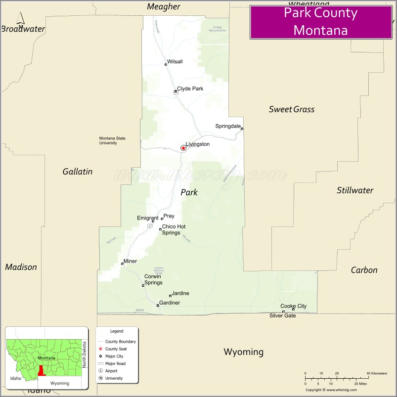
About Park County Map, Montana: The map showing the county boundary, county seat, major cities, highways, water bodies and neighbouring counties.
Other Montana Maps & Info
Map of Park County, Montana
Park County is a county located in the U.S. state of Montana. It's county seat is Livingston. As per 2020 census, the population of Park County is 17473 people and population density is square miles. According to the United States Census Bureau, the county has a total area of 2,656 sq mi (6,879 km2). Park County was established on -4693.
Park County Facts
| Continent | North America |
| Country | United States |
| State | Montana |
| County Seat | Livingston |
| Largest City/Town | Livingston |
| Established | 1887 |
| Total Area | 2,813 sq mi (7,286 sq km) |
| Land Area | 2,802 sq mi (7,257 sq km) |
| Water Area | 11 sq mi (29 sq km) |
| Population | 17,939 (Census 2020) |
| Population Density | 6.4 people per sq mi |
| Time Zone | Mountain Time Zone (MST/MDT) |
| Major Highways | Interstate 90, U.S. Route 89, U.S. Route 191 |
| Major Rivers | Yellowstone River, Shields River |
| Neighboring Counties | Gallatin County, Sweet Grass County, Stillwater County, Meagher County |
| Famous For | Yellowstone National Park gateway, fly fishing, mountain scenery, and western heritage |
| Top Attractions | Yellowstone National Park North Entrance nearby region, Livingston Historic District, Paradise Valley, and Chico Hot Springs |
| Official Website | Official Website |
About Park County, Montana
Park County is located in south-central Montana in the western United States and was established in 1887. The county seat and largest city is Livingston. The county is known for its stunning Rocky Mountain scenery, Yellowstone National Park gateway communities, world-class fly fishing, and historic western culture.
Cities and Towns in Park County, Montana
| City/Town | Population (Census 2020) | Latitude & Longitude |
|---|---|---|
| Livingston (county seat) | 8,040 | 45.6629°N, 110.5600°W |
| Clyde Park | 288 | 45.8849°N, 110.6077°W |
| Wilsall | 178 | 46.0407°N, 110.6666°W |
| Gardiner | 745 | 45.0319°N, 110.7055°W |
| Cooke City | 77 | 45.0205°N, 109.9398°W |
| Pray (CDP) | 681 | 45.4810°N, 110.7134°W |
Golf Courses in Park County, Montana
| Golf Course | Location | Latitude & Longitude |
|---|---|---|
| Livingston Golf & Country Club | Livingston | 45.6711°N, 110.5679°W |
| Paradise Valley Golf Recreation Area | Pray | 45.4868°N, 110.7195°W |
Major Roads and Highways in Park County, Montana
Major highways connect the county with Yellowstone National Park and regional Montana destinations.
- Interstate 90 - major east-west interstate through Livingston and southern Montana
- U.S. Route 89 - scenic route through Paradise Valley toward Yellowstone National Park
- U.S. Route 191 - highway connecting southwestern Montana recreation regions
What are the Neighboring Counties of Park County
- Meagher County (north)
- Sweet Grass County (east)
- Stillwater County (southeast)
- Gallatin County (west)
What are the top Attractions in Park County, Montana
The county offers a mix of mountain recreation, Yellowstone tourism, and western history.
- Yellowstone National Park North Entrance nearby region - world-famous national park entrance through Gardiner
- Livingston Historic District - preserved downtown with western architecture, galleries, and museums
- Paradise Valley - scenic valley known for ranches, mountain views, and fly fishing
- Chico Hot Springs - historic hot springs resort and recreation destination
- Yellowstone River - nationally known fly fishing and rafting river
- Absaroka-Beartooth Wilderness nearby region - hiking, camping, and alpine recreation area
- Cooke City Scenic Area - mountain town near Yellowstone with snowmobiling and outdoor recreation
- Museum of the Rockies nearby region access - educational and natural history attractions
- Livingston Depot Center - restored railroad depot museum and cultural venue
- Bridger Bowl and Mountain Recreation Areas nearby region - skiing and outdoor activities
Distance from Park County to Nearby Cities
The following distances are measured by road (driving).
- Livingston to Bozeman (Gallatin County), Montana - 26 mi (42 km)
- Livingston to Billings (Yellowstone County), Montana - 116 mi (187 km)
- Livingston to Gardiner (Park County), Montana - 53 mi (85 km)
- Livingston to Clyde Park (Park County), Montana - 24 mi (39 km)
- Livingston to Helena (Lewis and Clark County), Montana - 143 mi (230 km)
- Livingston to Missoula (Missoula County), Montana - 228 mi (367 km)
- Livingston to Cody (Park County), Wyoming - 110 mi (177 km)
- Livingston to Jackson (Teton County), Wyoming - 196 mi (315 km)
- Livingston to Rapid City (Pennington County), South Dakota - 398 mi (641 km)
- Livingston to Salt Lake City (Salt Lake County), Utah - 436 mi (702 km)
- Livingston to Denver (Denver County), Colorado - 557 mi (896 km)
- Livingston to Spokane (Spokane County), Washington - 533 mi (858 km)
- Livingston to Calgary, Alberta - 486 mi (782 km)
FAQs about Park County
Park County is located in south-central Montana near Yellowstone National Park.
Park County had a population of 17,939 according to the 2020 United States Census.
Park County is known for Yellowstone tourism, fly fishing, mountain scenery, and western heritage.
The county is served by Interstate 90, U.S. Route 89, and U.S. Route 191.
Yes, Park County includes golf facilities such as Livingston Golf & Country Club and recreation golf areas in Paradise Valley.
References
- QuickFacts - U.S. Census Bureau
- United States Census Bureau
- United States Geological Survey (USGS)
- National Geodetic Survey
- Official Website
- Beaverhead County Map
- Big Horn County Map
- Blaine County Map
- Broadwater County Map
- Carbon County Map
- Carter County Map
- Cascade County Map
- Chouteau County Map
- Custer County Map
- Daniels County Map
- Dawson County Map
- Deer Lodge County Map
- Fallon County Map
- Fergus County Map
- Flathead County Map
- Gallatin County Map
- Garfield County Map
- Glacier County Map
- Golden Valley County Map
- Granite County Map
- Hill County Map
- Jefferson County Map
- Judith Basin County Map
- Lake County Map
- Lewis and Clark County Map
- Liberty County Map
- Lincoln County Map
- McCone County Map
- Madison County Map
- Meagher County Map
- Mineral County Map
- Missoula County Map
- Musselshell County Map
- Park County Map
- Petroleum County Map
- Phillips County Map
- Pondera County Map
- Powder River County Map
- Powell County Map
- Prairie County Map
- Ravalli County Map
- Richland County Map
- Roosevelt County Map
- Rosebud County Map
- Sanders County Map
- Sheridan County Map
- Silver Bow County Map
- Stillwater County Map
- Sweet Grass County Map
- Teton County Map
- Toole County Map
- Treasure County Map
- Valley County Map
- Wheatland County Map
- Wibaux County Map
- Yellowstone County Map
- Alabama Counties
- Alaska boroughs
- Arizona Counties
- Arkansas Counties
- California County Map
- Colorado Counties
- Connecticut Counties
- Delaware Counties
- Florida County Map
- Georgia County Map
- Hawaii Counties
- Idaho Counties
- Illinois Counties
- Indiana Counties
- Iowa Counties
- Kansas Counties
- Kentucky Counties
- Louisiana Counties
- Maine Counties
- Maryland Counties
- Massachusetts Counties
- Michigan County Map
- Minnesota Counties
- Mississippi Counties
- Missouri Counties
- Montana Counties
- Nebraska Counties
- Nevada Counties
- New York Counties
- New Hampshire Counties
- New Jersey Counties
- New Mexico Counties
- North Carolina Counties
- North Dakota Counties
- Ohio County Map
- Oklahoma Counties
- Oregon Counties
- Pennsylvania Counties
- Rhode Island Counties
- South Carolina Counties
- South Dakota Counties
- Map of Tennessee
- Texas County Map
- Utah Counties
- Vermont Counties
- Virginia Counties
- Washington Counties
- West Virginia Counties
- Wisconsin Counties
- Wyoming Counties