Map of Fergus County - Fergus County is a county located in the U.S. state of Montana. Fergus County Map showing cities, highways, important places and water bodies. Get Where is Fergus County located in the map, major cities in Fergus county, population, areas, and places of interest.
Map of Fergus County, Montana
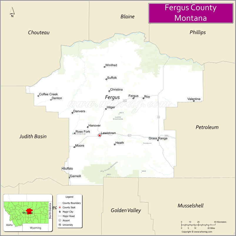
About Fergus County Map, Montana: The map showing the county boundary, county seat, major cities, highways, water bodies and neighbouring counties.
Other Montana Maps & Info
Map of Fergus County, Montana
Fergus County is a county located in the U.S. state of Montana. It's county seat is Lewistown. As per 2020 census, the population of Fergus County is 11617 people and population density is square miles. According to the United States Census Bureau, the county has a total area of 4,339 sq mi (11,238 km2). Fergus County was established on -5406.
Fergus County Facts
| Continent | North America |
| Country | United States |
| State | Montana |
| County Seat | Lewistown |
| Largest City/Town | Lewistown |
| Established | 1885 |
| Total Area | 4,339 sq mi (11,238 sq km) |
| Land Area | 4,297 sq mi (11,129 sq km) |
| Water Area | 42 sq mi (109 sq km) |
| Population | 11,050 (Census 2020) |
| Population Density | 2.6 people per sq mi |
| Time Zone | Mountain Time Zone (MST/MDT) |
| Major Highways | U.S. Route 87, U.S. Route 191, Montana Highway 200 |
| Major Rivers | Judith River, Musselshell River |
| Neighboring Counties | Blaine County, Chouteau County, Judith Basin County, Petroleum County, Garfield County, Golden Valley County, Wheatland County |
| Famous For | Central Montana ranching, Judith Mountains, and historic Lewistown |
| Top Attractions | Big Spring Creek, Lewistown historic district, Crystal Lake, and Judith Peak Scenic Area |
| Official Website | Official Website |
About Fergus County, Montana
Fergus County is located in central Montana in the western United States and was established in 1885. The county seat and largest city is Lewistown. The county is known for its cattle ranching heritage, scenic mountain ranges, prairie landscapes, and historic role as a regional agricultural and trade center in central Montana.
Cities and Towns in Fergus County, Montana
| City/Town | Population (Census 2020) | Latitude & Longitude |
|---|---|---|
| Lewistown (county seat) | 5,952 | 47.0620°N, 109.4282°W |
| Denton | 255 | 47.3202°N, 109.8727°W |
| Grass Range | 110 | 46.8135°N, 108.8035°W |
| Moore | 186 | 46.8971°N, 109.6960°W |
| Winifred | 175 | 47.5565°N, 109.3817°W |
| Hilger (CDP) | 31 | 47.4335°N, 109.3411°W |
Golf Courses in Fergus County, Montana
| Golf Course | Location | Latitude & Longitude |
|---|---|---|
| Frank Day Memorial Golf Course | Lewistown | 47.0665°N, 109.4387°W |
| Judith Mountains Golf Recreation Area | Lewistown | 47.0713°N, 109.4219°W |
Major Roads and Highways in Fergus County, Montana
Major highways connect the county with central Montana communities and prairie regions.
- U.S. Route 87 - major north-south highway linking Lewistown with Great Falls and Billings
- U.S. Route 191 - regional route connecting agricultural and ranching communities
- Montana Highway 200 - scenic east-west route across central Montana
What are the Neighboring Counties of Fergus County
- Blaine County (north)
- Chouteau County (northwest)
- Judith Basin County (west)
- Wheatland County (southwest)
- Golden Valley County (south)
- Petroleum County (east)
- Garfield County (southeast)
What are the top Attractions in Fergus County, Montana
The county offers a mix of scenic mountains, historic communities, and outdoor recreation.
- Big Spring Creek - clear spring-fed stream popular for fishing and walking trails
- Lewistown Historic District - preserved downtown with historic architecture, shops, and museums
- Crystal Lake - scenic recreation area for boating, camping, and hiking in the Big Snowy Mountains
- Judith Peak Scenic Area - mountain recreation destination with hiking and panoramic views
- Central Montana Museum - local history museum featuring ranching and pioneer exhibits
- Beargulch Pictographs - Native American rock art site with archaeological significance
- Big Snowy Mountains - mountain range offering hiking, wildlife viewing, and camping opportunities
- Frank Day Park - recreation area and sports facilities in Lewistown
- Winifred Museum and Heritage Sites - prairie community history attractions
- Missouri River Breaks nearby region - scenic landscapes and wildlife habitats
Distance from Fergus County to Nearby Cities
The following distances are measured by road (driving).
- Lewistown to Great Falls (Cascade County), Montana - 126 mi (203 km)
- Lewistown to Billings (Yellowstone County), Montana - 133 mi (214 km)
- Lewistown to Helena (Lewis and Clark County), Montana - 122 mi (196 km)
- Lewistown to Bozeman (Gallatin County), Montana - 173 mi (278 km)
- Lewistown to Havre (Hill County), Montana - 144 mi (232 km)
- Lewistown to Denton (Fergus County), Montana - 35 mi (56 km)
- Lewistown to Grass Range (Fergus County), Montana - 33 mi (53 km)
- Lewistown to Miles City (Custer County), Montana - 160 mi (257 km)
- Lewistown to Glasgow (Valley County), Montana - 177 mi (285 km)
- Lewistown to Missoula (Missoula County), Montana - 238 mi (383 km)
- Lewistown to Kalispell (Flathead County), Montana - 258 mi (415 km)
- Lewistown to Rapid City (Pennington County), South Dakota - 415 mi (668 km)
- Lewistown to Denver (Denver County), Colorado - 640 mi (1,030 km)
FAQs about Fergus County
Fergus County is located in central Montana in the Judith Basin region.
Fergus County had a population of 11,050 according to the 2020 United States Census.
Fergus County is known for ranching, scenic mountain ranges, and the historic city of Lewistown.
The county is served by U.S. Route 87, U.S. Route 191, and Montana Highway 200.
Yes, Fergus County includes golf facilities such as Frank Day Memorial Golf Course and recreation golf areas near the Judith Mountains.
References
- QuickFacts - U.S. Census Bureau
- United States Census Bureau
- United States Geological Survey (USGS)
- National Geodetic Survey
- Official Website
- Beaverhead County Map
- Big Horn County Map
- Blaine County Map
- Broadwater County Map
- Carbon County Map
- Carter County Map
- Cascade County Map
- Chouteau County Map
- Custer County Map
- Daniels County Map
- Dawson County Map
- Deer Lodge County Map
- Fallon County Map
- Fergus County Map
- Flathead County Map
- Gallatin County Map
- Garfield County Map
- Glacier County Map
- Golden Valley County Map
- Granite County Map
- Hill County Map
- Jefferson County Map
- Judith Basin County Map
- Lake County Map
- Lewis and Clark County Map
- Liberty County Map
- Lincoln County Map
- McCone County Map
- Madison County Map
- Meagher County Map
- Mineral County Map
- Missoula County Map
- Musselshell County Map
- Park County Map
- Petroleum County Map
- Phillips County Map
- Pondera County Map
- Powder River County Map
- Powell County Map
- Prairie County Map
- Ravalli County Map
- Richland County Map
- Roosevelt County Map
- Rosebud County Map
- Sanders County Map
- Sheridan County Map
- Silver Bow County Map
- Stillwater County Map
- Sweet Grass County Map
- Teton County Map
- Toole County Map
- Treasure County Map
- Valley County Map
- Wheatland County Map
- Wibaux County Map
- Yellowstone County Map
- Alabama Counties
- Alaska boroughs
- Arizona Counties
- Arkansas Counties
- California County Map
- Colorado Counties
- Connecticut Counties
- Delaware Counties
- Florida County Map
- Georgia County Map
- Hawaii Counties
- Idaho Counties
- Illinois Counties
- Indiana Counties
- Iowa Counties
- Kansas Counties
- Kentucky Counties
- Louisiana Counties
- Maine Counties
- Maryland Counties
- Massachusetts Counties
- Michigan County Map
- Minnesota Counties
- Mississippi Counties
- Missouri Counties
- Montana Counties
- Nebraska Counties
- Nevada Counties
- New York Counties
- New Hampshire Counties
- New Jersey Counties
- New Mexico Counties
- North Carolina Counties
- North Dakota Counties
- Ohio County Map
- Oklahoma Counties
- Oregon Counties
- Pennsylvania Counties
- Rhode Island Counties
- South Carolina Counties
- South Dakota Counties
- Map of Tennessee
- Texas County Map
- Utah Counties
- Vermont Counties
- Virginia Counties
- Washington Counties
- West Virginia Counties
- Wisconsin Counties
- Wyoming Counties