Map of Teton County - Teton County is a county located in the U.S. state of Montana. Teton County Map showing cities, highways, important places and water bodies. Get Where is Teton County located in the map, major cities in Teton county, population, areas, and places of interest.
Map of Teton County, Montana
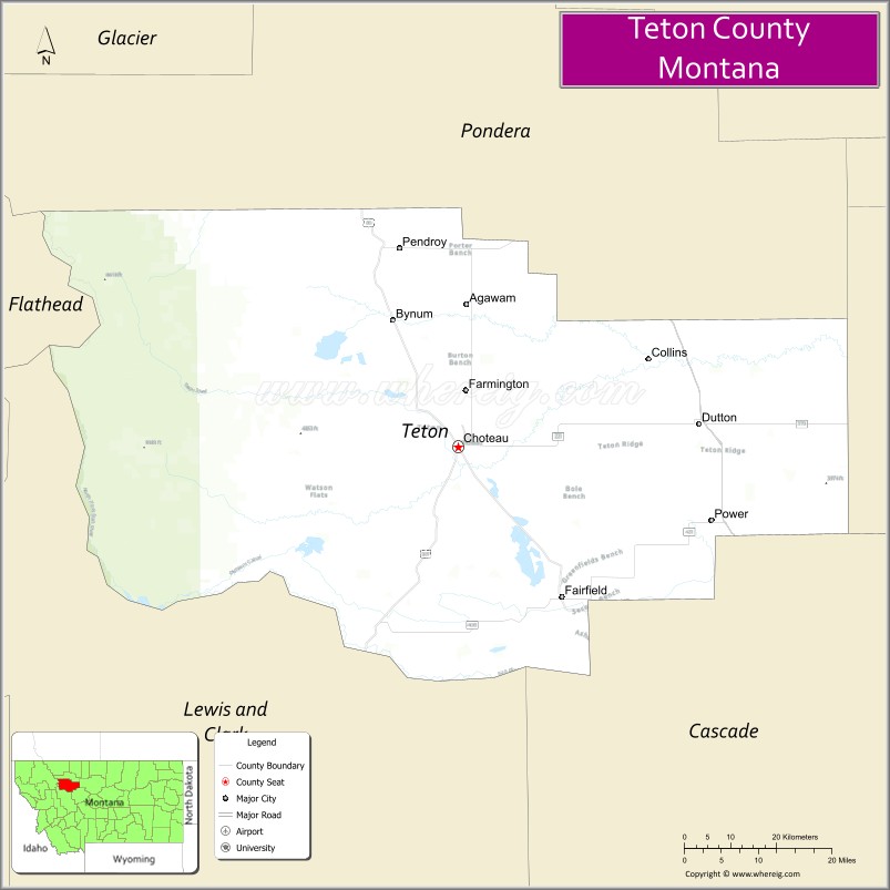
About Teton County Map, Montana: The map showing the county boundary, county seat, major cities, highways, water bodies and neighbouring counties.
Other Montana Maps & Info
Map of Teton County, Montana
Teton County is a county located in the U.S. state of Montana. It's county seat is Choteau. As per 2020 census, the population of Teton County is 6269 people and population density is square miles. According to the United States Census Bureau, the county has a total area of 2,273 sq mi (5,887 km2). Teton County was established on -2517.
Teton County Facts
| Continent | North America |
| Country | United States |
| State | Montana |
| County Seat | Choteau |
| Largest City/Town | Choteau |
| Established | 1893 |
| Total Area | 2,293 sq mi (5,939 sq km) |
| Land Area | 2,272 sq mi (5,884 sq km) |
| Water Area | 21 sq mi (54 sq km) |
| Population | 6,147 (Census 2020) |
| Population Density | 2.7 people per sq mi |
| Time Zone | Mountain Time Zone (MST/MDT) |
| Major Highways | U.S. Route 89, Montana Highway 200, Interstate 15 nearby region |
| Major Rivers | Teton River, Sun River, Marias River |
| Neighboring Counties | Pondera County, Lewis and Clark County, Cascade County, Flathead County nearby region |
| Famous For | Rocky Mountain Front, dinosaur discoveries, ranching, and prairie-to-mountain scenery |
| Top Attractions | Old Trail Museum, Rocky Mountain Front, Freezeout Lake Wildlife Management Area nearby region, and Teton Pass scenery |
| Official Website | Official Website |
About Teton County, Montana
Teton County is located in north-central Montana in the western United States and was established in 1893. The county seat and largest town is Choteau. The county is known for its dramatic Rocky Mountain Front scenery, ranching heritage, dinosaur fossil discoveries, and diverse outdoor recreation opportunities.
Cities and Towns in Teton County, Montana
| City/Town | Population (Census 2020) | Latitude & Longitude |
|---|---|---|
| Choteau (county seat) | 1,721 | 47.8125°N, 112.1839°W |
| Dutton | 301 | 47.8480°N, 111.7116°W |
| Fairfield | 708 | 47.6144°N, 111.9802°W |
| Power | 171 | 47.7164°N, 111.6933°W |
| Bynum | 31 | 47.9738°N, 112.2527°W |
| Pendroy | 42 | 48.0621°N, 112.1385°W |
Golf Courses in Teton County, Montana
| Golf Course | Location | Latitude & Longitude |
|---|---|---|
| Choteau Country Club | Choteau | 47.8190°N, 112.1905°W |
| Fairfield Golf & Country Club | Fairfield | 47.6207°N, 111.9874°W |
Major Roads and Highways in Teton County, Montana
Major highways connect the county with north-central Montana ranching communities and Rocky Mountain recreation areas.
- U.S. Route 89 - scenic north-south highway along the Rocky Mountain Front
- Montana Highway 200 - east-west regional transportation corridor
- Interstate 15 nearby region - major interstate serving nearby north-central Montana areas
What are the Neighboring Counties of Teton County
- Pondera County (north)
- Cascade County (east)
- Lewis and Clark County (south)
- Flathead County nearby region (west)
What are the top Attractions in Teton County, Montana
The county offers a mix of mountain scenery, wildlife viewing, and western heritage attractions.
- Old Trail Museum - museum featuring dinosaur fossils, Native American artifacts, and pioneer history
- Rocky Mountain Front - dramatic mountain scenery with hiking and wildlife viewing opportunities
- Freezeout Lake Wildlife Management Area nearby region - major migratory birdwatching destination
- Teton Pass Scenic Area - panoramic mountain and prairie landscapes
- Bynum Dinosaur Center - exhibits showcasing regional dinosaur discoveries and paleontology
- Teton River Recreation Areas - fishing, camping, and wildlife observation locations
- Choteau Historic District - western downtown architecture and local museums
- Bob Marshall Wilderness nearby region - backcountry hiking and wilderness adventures
- Sun River Valley Scenic Drives - countryside routes with mountain views and ranchlands
- North-Central Montana Prairie Landscapes - expansive agricultural and open-range scenery
Distance from Teton County to Nearby Cities
The following distances are measured by road (driving).
- Choteau to Great Falls (Cascade County), Montana - 54 mi (87 km)
- Choteau to Helena (Lewis and Clark County), Montana - 100 mi (161 km)
- Choteau to Cut Bank (Glacier County), Montana - 77 mi (124 km)
- Choteau to Conrad (Pondera County), Montana - 36 mi (58 km)
- Choteau to Fairfield (Teton County), Montana - 26 mi (42 km)
- Choteau to Dutton (Teton County), Montana - 27 mi (43 km)
- Choteau to Kalispell (Flathead County), Montana - 129 mi (208 km)
- Choteau to Missoula (Missoula County), Montana - 193 mi (311 km)
- Choteau to Bozeman (Gallatin County), Montana - 195 mi (314 km)
- Choteau to Billings (Yellowstone County), Montana - 255 mi (410 km)
- Choteau to Calgary, Alberta - 234 mi (377 km)
- Choteau to Spokane (Spokane County), Washington - 420 mi (676 km)
- Choteau to Denver (Denver County), Colorado - 762 mi (1,226 km)
FAQs about Teton County
Teton County is located in north-central Montana along the Rocky Mountain Front.
Teton County had a population of 6,147 according to the 2020 United States Census.
Teton County is known for mountain scenery, dinosaur discoveries, ranching, and wildlife recreation.
The county is served by U.S. Route 89 and Montana Highway 200.
Yes, Teton County includes golf facilities such as Choteau Country Club and Fairfield Golf & Country Club.
References
- QuickFacts - U.S. Census Bureau
- United States Census Bureau
- United States Geological Survey (USGS)
- National Geodetic Survey
- Official Website
- Beaverhead County Map
- Big Horn County Map
- Blaine County Map
- Broadwater County Map
- Carbon County Map
- Carter County Map
- Cascade County Map
- Chouteau County Map
- Custer County Map
- Daniels County Map
- Dawson County Map
- Deer Lodge County Map
- Fallon County Map
- Fergus County Map
- Flathead County Map
- Gallatin County Map
- Garfield County Map
- Glacier County Map
- Golden Valley County Map
- Granite County Map
- Hill County Map
- Jefferson County Map
- Judith Basin County Map
- Lake County Map
- Lewis and Clark County Map
- Liberty County Map
- Lincoln County Map
- McCone County Map
- Madison County Map
- Meagher County Map
- Mineral County Map
- Missoula County Map
- Musselshell County Map
- Park County Map
- Petroleum County Map
- Phillips County Map
- Pondera County Map
- Powder River County Map
- Powell County Map
- Prairie County Map
- Ravalli County Map
- Richland County Map
- Roosevelt County Map
- Rosebud County Map
- Sanders County Map
- Sheridan County Map
- Silver Bow County Map
- Stillwater County Map
- Sweet Grass County Map
- Teton County Map
- Toole County Map
- Treasure County Map
- Valley County Map
- Wheatland County Map
- Wibaux County Map
- Yellowstone County Map
- Alabama Counties
- Alaska boroughs
- Arizona Counties
- Arkansas Counties
- California County Map
- Colorado Counties
- Connecticut Counties
- Delaware Counties
- Florida County Map
- Georgia County Map
- Hawaii Counties
- Idaho Counties
- Illinois Counties
- Indiana Counties
- Iowa Counties
- Kansas Counties
- Kentucky Counties
- Louisiana Counties
- Maine Counties
- Maryland Counties
- Massachusetts Counties
- Michigan County Map
- Minnesota Counties
- Mississippi Counties
- Missouri Counties
- Montana Counties
- Nebraska Counties
- Nevada Counties
- New York Counties
- New Hampshire Counties
- New Jersey Counties
- New Mexico Counties
- North Carolina Counties
- North Dakota Counties
- Ohio County Map
- Oklahoma Counties
- Oregon Counties
- Pennsylvania Counties
- Rhode Island Counties
- South Carolina Counties
- South Dakota Counties
- Map of Tennessee
- Texas County Map
- Utah Counties
- Vermont Counties
- Virginia Counties
- Washington Counties
- West Virginia Counties
- Wisconsin Counties
- Wyoming Counties