Map of McCone County - McCone County is a county located in the U.S. state of Montana. McCone County Map showing cities, highways, important places and water bodies. Get Where is McCone County located in the map, major cities in McCone county, population, areas, and places of interest.
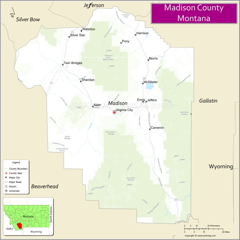
Map of Madison County, Montana
About McCone County Map, Montana: The map showing the county boundary, county seat, major cities, highways, water bodies and neighbouring counties.
Other Montana Maps & Info
Map of Madison County, Montana
Madison County is a county located in the U.S. state of Montana. It's county seat is Virginia City. As per 2020 census, the population of Madison County is 8917 people and population density is square miles. According to the United States Census Bureau, the county has a total area of 3,587 sq mi (9,290 km2). Madison County was established on -12749.
Madison County Facts
| Continent | North America |
| Country | United States |
| State | Montana |
| County Seat | Virginia City |
| Largest City/Town | Ennis |
| Established | 1865 |
| Total Area | 3,603 sq mi (9,332 sq km) |
| Land Area | 3,581 sq mi (9,275 sq km) |
| Water Area | 22 sq mi (57 sq km) |
| Population | 9,152 (Census 2020) |
| Population Density | 2.6 people per sq mi |
| Time Zone | Mountain Time Zone (MST/MDT) |
| Major Highways | U.S. Route 287, Montana Highway 41, Montana Highway 84 |
| Major Rivers | Madison River, Jefferson River, Ruby River |
| Neighboring Counties | Jefferson County, Gallatin County, Beaverhead County, Silver Bow County, Broadwater County |
| Famous For | Virginia City historic gold rush heritage, fly fishing, and scenic mountain valleys |
| Top Attractions | Virginia City Historic District, Madison River, Nevada City, and Ennis Lake |
| Official Website | Official Website |
About Madison County, Montana
Madison County is located in southwestern Montana in the western United States and was established in 1865. The county seat is Virginia City, while Ennis is the largest community. The county is known for its gold rush history, world-class fly fishing, scenic mountain landscapes, and preserved frontier towns.
Cities and Towns in Madison County, Montana
| City/Town | Population (Census 2020) | Latitude & Longitude |
|---|---|---|
| Virginia City (county seat) | 190 | 45.2935°N, 111.9469°W |
| Ennis | 917 | 45.3483°N, 111.7316°W |
| Sheridan | 694 | 45.4577°N, 112.1961°W |
| Twin Bridges | 375 | 45.5407°N, 112.4345°W |
| Whitehall (partial) | 1,038 | 45.8705°N, 112.0967°W |
| Harrison (CDP) | 137 | 45.7016°N, 111.7850°W |
Golf Courses in Madison County, Montana
| Golf Course | Location | Latitude & Longitude |
|---|---|---|
| Madison Meadows Golf Course | Ennis | 45.3518°N, 111.7382°W |
| Jefferson Valley Golf Club | Twin Bridges | 45.5469°N, 112.4408°W |
Major Roads and Highways in Madison County, Montana
Major highways connect the county with southwestern Montana recreation and historic destinations.
- U.S. Route 287 - scenic highway following the Madison River Valley
- Montana Highway 41 - route connecting Twin Bridges, Sheridan, and Dillon regions
- Montana Highway 84 - regional route serving the Madison Valley and nearby recreation areas
What are the Neighboring Counties of Madison County
- Broadwater County (north)
- Gallatin County (east)
- Jefferson County (northwest)
- Silver Bow County (west)
- Beaverhead County (southwest)
What are the top Attractions in Madison County, Montana
The county offers a mix of historic frontier towns, river recreation, and mountain scenery.
- Virginia City Historic District - preserved gold rush town with museums, shops, and historic buildings
- Madison River - world-famous fly fishing river with scenic mountain surroundings
- Nevada City - living history museum and restored Old West community near Virginia City
- Ennis Lake - recreation destination for boating, fishing, and camping
- Big Sky Scenic Region nearby area - mountain recreation and hiking opportunities
- Ruby Valley - picturesque valley known for ranching and scenic drives
- Lewis and Clark Caverns nearby region - limestone cave system and hiking trails
- Madison Buffalo Jump State Park nearby region - archaeological and cultural site
- Ennis Downtown District - western-style shops, art galleries, and restaurants
- Gravelly Range Scenic Area - wilderness recreation and panoramic mountain views
Distance from Madison County to Nearby Cities
The following distances are measured by road (driving).
- Ennis to Bozeman (Gallatin County), Montana - 53 mi (85 km)
- Ennis to Virginia City (Madison County), Montana - 15 mi (24 km)
- Ennis to Sheridan (Madison County), Montana - 36 mi (58 km)
- Ennis to Twin Bridges (Madison County), Montana - 49 mi (79 km)
- Ennis to Butte (Silver Bow County), Montana - 73 mi (117 km)
- Ennis to Helena (Lewis and Clark County), Montana - 119 mi (192 km)
- Ennis to Dillon (Beaverhead County), Montana - 69 mi (111 km)
- Ennis to Missoula (Missoula County), Montana - 195 mi (314 km)
- Ennis to Idaho Falls (Bonneville County), Idaho - 160 mi (257 km)
- Ennis to Salt Lake City (Salt Lake County), Utah - 414 mi (666 km)
- Ennis to Denver (Denver County), Colorado - 651 mi (1,048 km)
- Ennis to Spokane (Spokane County), Washington - 437 mi (703 km)
- Ennis to Jackson (Teton County), Wyoming - 165 mi (266 km)
FAQs about Madison County
Madison County is located in southwestern Montana in the Rocky Mountain region.
Madison County had a population of 9,152 according to the 2020 United States Census.
Madison County is known for Virginia City, fly fishing on the Madison River, and historic gold rush heritage.
The county is served by U.S. Route 287, Montana Highway 41, and Montana Highway 84.
Yes, Madison County includes golf facilities such as Madison Meadows Golf Course and Jefferson Valley Golf Club.
References
- QuickFacts - U.S. Census Bureau
- United States Census Bureau
- United States Geological Survey (USGS)
- National Geodetic Survey
- Official Website
- Beaverhead County Map
- Big Horn County Map
- Blaine County Map
- Broadwater County Map
- Carbon County Map
- Carter County Map
- Cascade County Map
- Chouteau County Map
- Custer County Map
- Daniels County Map
- Dawson County Map
- Deer Lodge County Map
- Fallon County Map
- Fergus County Map
- Flathead County Map
- Gallatin County Map
- Garfield County Map
- Glacier County Map
- Golden Valley County Map
- Granite County Map
- Hill County Map
- Jefferson County Map
- Judith Basin County Map
- Lake County Map
- Lewis and Clark County Map
- Liberty County Map
- Lincoln County Map
- McCone County Map
- Madison County Map
- Meagher County Map
- Mineral County Map
- Missoula County Map
- Musselshell County Map
- Park County Map
- Petroleum County Map
- Phillips County Map
- Pondera County Map
- Powder River County Map
- Powell County Map
- Prairie County Map
- Ravalli County Map
- Richland County Map
- Roosevelt County Map
- Rosebud County Map
- Sanders County Map
- Sheridan County Map
- Silver Bow County Map
- Stillwater County Map
- Sweet Grass County Map
- Teton County Map
- Toole County Map
- Treasure County Map
- Valley County Map
- Wheatland County Map
- Wibaux County Map
- Yellowstone County Map
- Alabama Counties
- Alaska boroughs
- Arizona Counties
- Arkansas Counties
- California County Map
- Colorado Counties
- Connecticut Counties
- Delaware Counties
- Florida County Map
- Georgia County Map
- Hawaii Counties
- Idaho Counties
- Illinois Counties
- Indiana Counties
- Iowa Counties
- Kansas Counties
- Kentucky Counties
- Louisiana Counties
- Maine Counties
- Maryland Counties
- Massachusetts Counties
- Michigan County Map
- Minnesota Counties
- Mississippi Counties
- Missouri Counties
- Montana Counties
- Nebraska Counties
- Nevada Counties
- New York Counties
- New Hampshire Counties
- New Jersey Counties
- New Mexico Counties
- North Carolina Counties
- North Dakota Counties
- Ohio County Map
- Oklahoma Counties
- Oregon Counties
- Pennsylvania Counties
- Rhode Island Counties
- South Carolina Counties
- South Dakota Counties
- Map of Tennessee
- Texas County Map
- Utah Counties
- Vermont Counties
- Virginia Counties
- Washington Counties
- West Virginia Counties
- Wisconsin Counties
- Wyoming Counties