Map of Daniels County - Daniels County is a county located in the U.S. state of Montana. Daniels County Map showing cities, highways, important places and water bodies. Get Where is Daniels County located in the map, major cities in Daniels county, population, areas, and places of interest.
Map of Daniels County, Montana
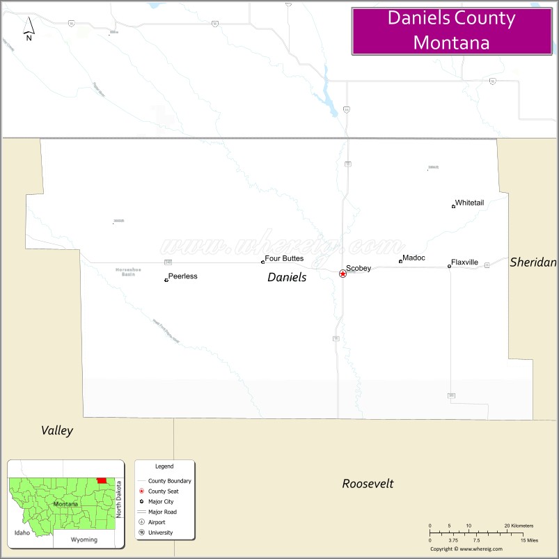
About Daniels County Map, Montana: The map showing the county boundary, county seat, major cities, highways, water bodies and neighbouring counties.
Other Montana Maps & Info
Map of Daniels County, Montana
Daniels County is a county located in the U.S. state of Montana. It's county seat is Scobey. As per 2020 census, the population of Daniels County is 1686 people and population density is square miles. According to the United States Census Bureau, the county has a total area of 1,426 sq mi (3,693 km2). Daniels County was established on 7548.
Daniels County Facts
| Continent | North America |
| Country | United States |
| State | Montana |
| County Seat | Scobey |
| Largest City/Town | Scobey |
| Established | 1920 |
| Total Area | 1,426 sq mi (3,693 sq km) |
| Land Area | 1,426 sq mi (3,693 sq km) |
| Water Area | 0.2 sq mi (0.5 sq km) |
| Population | 1,661 (Census 2020) |
| Population Density | 1.2 people per sq mi |
| Time Zone | Mountain Time Zone (MST/MDT) |
| Major Highways | Montana Highway 13, Montana Highway 5 |
| Major Rivers | Poplar River, Big Muddy Creek |
| Neighboring Counties | Sheridan County, Roosevelt County, Valley County |
| Famous For | Prairie agriculture, northern Montana plains, and Canadian border proximity |
| Top Attractions | Daniels County Museum, Scobey downtown district, prairie scenic drives, and fishing recreation areas |
| Official Website | Official Website |
About Daniels County, Montana
Daniels County is located in northeastern Montana in the western United States and was established in 1920. The county seat and largest city is Scobey. The county is known for its wide-open prairie landscapes, wheat farming, ranching heritage, and small rural communities near the Canadian border.
Cities and Towns in Daniels County, Montana
| City/Town | Population (Census 2020) | Latitude & Longitude |
|---|---|---|
| Scobey (county seat) | 1,017 | 48.7914°N, 105.4206°W |
| Flaxville | 66 | 48.8042°N, 105.1710°W |
| Peerless (CDP) | 48 | 48.7833°N, 105.8993°W |
| Whitetail (CDP) | 52 | 48.8935°N, 105.3149°W |
| Richland (Rural Community) | 34 | 48.7215°N, 105.5324°W |
| Four Buttes (CDP) | 43 | 48.7346°N, 105.2358°W |
Golf Courses in Daniels County, Montana
| Golf Course | Location | Latitude & Longitude |
|---|---|---|
| Scobey Golf Club | Scobey | 48.7985°N, 105.4262°W |
| Daniels County Recreation Golf Area | Scobey | 48.7901°N, 105.4184°W |
Major Roads and Highways in Daniels County, Montana
Major highways connect the county with northeastern Montana communities and the Canadian border region.
- Montana Highway 13 - major north-south route linking Scobey with Circle and Plentywood
- Montana Highway 5 - east-west highway serving agricultural communities and prairie regions
What are the Neighboring Counties of Daniels County
- Roosevelt County (west)
- Valley County (south)
- Sheridan County (east)
What are the top Attractions in Daniels County, Montana
The county offers a mix of prairie scenery, local history, and outdoor recreation.
- Daniels County Museum - museum featuring pioneer artifacts, farming history, and local heritage exhibits
- Scobey Historic Downtown - traditional prairie town center with local businesses and historic buildings
- Prairie Scenic Drives - countryside routes featuring wheat fields, ranchlands, and open plains
- Big Muddy Creek Recreation Areas - outdoor areas for fishing and wildlife viewing
- Whitetail Reservoir Recreation Area - local destination for boating, camping, and fishing
- Flaxville Community Heritage Sites - historic agricultural community attractions
- Four Buttes Scenic Region - rolling prairie landscapes and unique geological features
- Canadian Border Scenic Routes - northern plains drives near the Saskatchewan border
- Poplar River Valley - natural prairie corridor with birdwatching opportunities
- Peerless Rural Landscapes - scenic ranching and farming areas typical of northeastern Montana
Distance from Daniels County to Nearby Cities
The following distances are measured by road (driving).
- Scobey to Plentywood (Sheridan County), Montana - 52 mi (84 km)
- Scobey to Glasgow (Valley County), Montana - 112 mi (180 km)
- Scobey to Wolf Point (Roosevelt County), Montana - 91 mi (146 km)
- Scobey to Sidney (Richland County), Montana - 133 mi (214 km)
- Scobey to Williston (Williams County), North Dakota - 154 mi (248 km)
- Scobey to Havre (Hill County), Montana - 201 mi (323 km)
- Scobey to Billings (Yellowstone County), Montana - 365 mi (587 km)
- Scobey to Flaxville (Daniels County), Montana - 16 mi (26 km)
- Scobey to Peerless (Daniels County), Montana - 28 mi (45 km)
- Scobey to Regina, Saskatchewan - 192 mi (309 km)
- Scobey to Great Falls (Cascade County), Montana - 281 mi (452 km)
- Scobey to Bismarck (Burleigh County), North Dakota - 290 mi (467 km)
- Scobey to Calgary, Alberta - 425 mi (684 km)
FAQs about Daniels County
Daniels County is located in northeastern Montana near the Canadian border.
Daniels County had a population of 1,661 according to the 2020 United States Census.
Daniels County is known for prairie agriculture, ranching, and scenic northern Montana plains.
The county is served by Montana Highway 13 and Montana Highway 5.
Yes, Daniels County includes golf facilities such as Scobey Golf Club and local recreation golf areas.
References
- QuickFacts - U.S. Census Bureau
- United States Census Bureau
- United States Geological Survey (USGS)
- National Geodetic Survey
- Official Website
- Beaverhead County Map
- Big Horn County Map
- Blaine County Map
- Broadwater County Map
- Carbon County Map
- Carter County Map
- Cascade County Map
- Chouteau County Map
- Custer County Map
- Daniels County Map
- Dawson County Map
- Deer Lodge County Map
- Fallon County Map
- Fergus County Map
- Flathead County Map
- Gallatin County Map
- Garfield County Map
- Glacier County Map
- Golden Valley County Map
- Granite County Map
- Hill County Map
- Jefferson County Map
- Judith Basin County Map
- Lake County Map
- Lewis and Clark County Map
- Liberty County Map
- Lincoln County Map
- McCone County Map
- Madison County Map
- Meagher County Map
- Mineral County Map
- Missoula County Map
- Musselshell County Map
- Park County Map
- Petroleum County Map
- Phillips County Map
- Pondera County Map
- Powder River County Map
- Powell County Map
- Prairie County Map
- Ravalli County Map
- Richland County Map
- Roosevelt County Map
- Rosebud County Map
- Sanders County Map
- Sheridan County Map
- Silver Bow County Map
- Stillwater County Map
- Sweet Grass County Map
- Teton County Map
- Toole County Map
- Treasure County Map
- Valley County Map
- Wheatland County Map
- Wibaux County Map
- Yellowstone County Map
- Alabama Counties
- Alaska boroughs
- Arizona Counties
- Arkansas Counties
- California County Map
- Colorado Counties
- Connecticut Counties
- Delaware Counties
- Florida County Map
- Georgia County Map
- Hawaii Counties
- Idaho Counties
- Illinois Counties
- Indiana Counties
- Iowa Counties
- Kansas Counties
- Kentucky Counties
- Louisiana Counties
- Maine Counties
- Maryland Counties
- Massachusetts Counties
- Michigan County Map
- Minnesota Counties
- Mississippi Counties
- Missouri Counties
- Montana Counties
- Nebraska Counties
- Nevada Counties
- New York Counties
- New Hampshire Counties
- New Jersey Counties
- New Mexico Counties
- North Carolina Counties
- North Dakota Counties
- Ohio County Map
- Oklahoma Counties
- Oregon Counties
- Pennsylvania Counties
- Rhode Island Counties
- South Carolina Counties
- South Dakota Counties
- Map of Tennessee
- Texas County Map
- Utah Counties
- Vermont Counties
- Virginia Counties
- Washington Counties
- West Virginia Counties
- Wisconsin Counties
- Wyoming Counties