Map of Valley County - Valley County is a county located in the U.S. state of Montana. Valley County Map showing cities, highways, important places and water bodies. Get Where is Valley County located in the map, major cities in Valley county, population, areas, and places of interest.
Map of Valley County, Montana
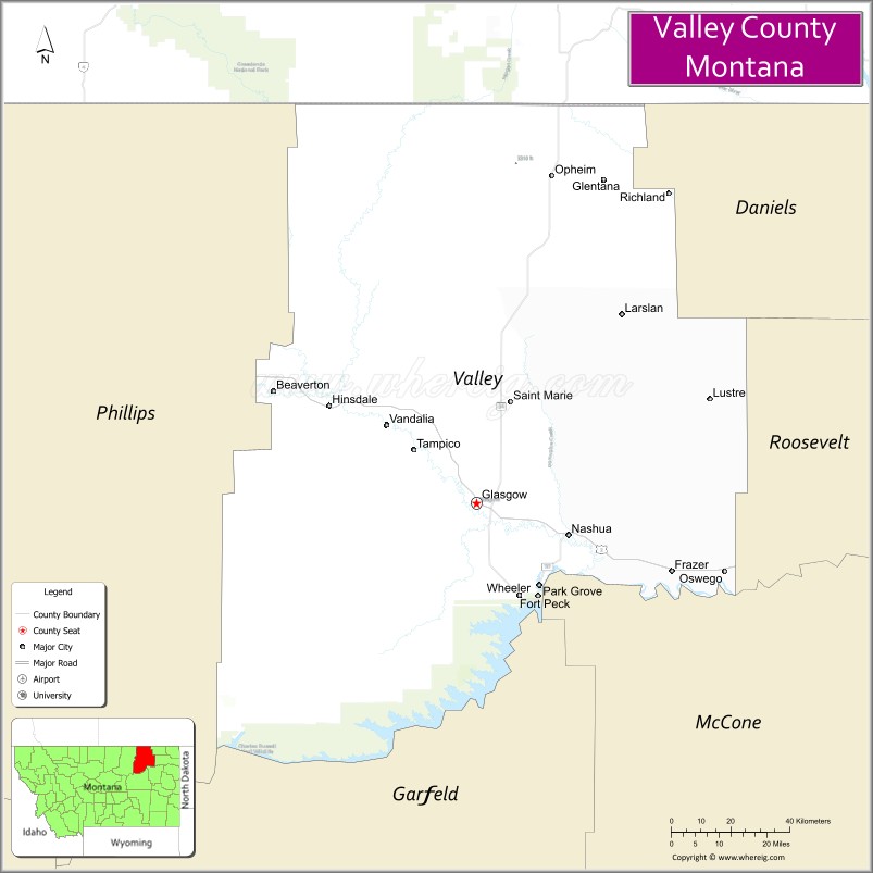
About Valley County Map, Montana: The map showing the county boundary, county seat, major cities, highways, water bodies and neighbouring counties.
Other Montana Maps & Info
Map of Valley County, Montana
Valley County is a county located in the U.S. state of Montana. It's county seat is Glasgow. As per 2020 census, the population of Valley County is 7537 people and population density is square miles. According to the United States Census Bureau, the county has a total area of 4,921 sq mi (12,745 km2). Valley County was established on -2518.
Valley County Facts
| Continent | North America |
| Country | United States |
| State | Montana |
| County Seat | Glasgow |
| Largest City/Town | Glasgow |
| Established | 1893 |
| Total Area | 5,062 sq mi (13,111 sq km) |
| Land Area | 4,926 sq mi (12,758 sq km) |
| Water Area | 136 sq mi (352 sq km) |
| Population | 7,578 (Census 2020) |
| Population Density | 1.5 people per sq mi |
| Time Zone | Mountain Time Zone (MST/MDT) |
| Major Highways | U.S. Route 2, Montana Highway 24 |
| Major Rivers | Milk River, Missouri River nearby region |
| Neighboring Counties | Phillips County, Roosevelt County, McCone County, Garfield County, Daniels County |
| Famous For | Fort Peck Dam nearby region, prairie landscapes, agriculture, and Missouri River recreation |
| Top Attractions | Fort Peck Lake nearby region, Glasgow historic district, Milk River Valley, and Fort Peck Interpretive Center nearby area |
| Official Website | Official Website |
About Valley County, Montana
Valley County is located in northeastern Montana in the western United States and was established in 1893. The county seat and largest city is Glasgow. The county is known for its wide-open prairie landscapes, agricultural economy, proximity to Fort Peck Lake, and outdoor recreation opportunities along the Milk and Missouri River regions.
Cities and Towns in Valley County, Montana
| City/Town | Population (Census 2020) | Latitude & Longitude |
|---|---|---|
| Glasgow (county seat) | 3,202 | 48.1958°N, 106.6359°W |
| Nashua | 325 | 48.1316°N, 106.3595°W |
| Opheim | 83 | 48.8575°N, 106.4031°W |
| Frazer | 364 | 48.0608°N, 106.0406°W |
| Lustre | 37 | 48.3592°N, 106.6378°W |
| Saint Marie | 261 | 48.4087°N, 106.5020°W |
Golf Courses in Valley County, Montana
| Golf Course | Location | Latitude & Longitude |
|---|---|---|
| Sunnyside Country Club | Glasgow | 48.2026°N, 106.6425°W |
| Nashua Prairie Golf Area | Nashua | 48.1378°N, 106.3658°W |
Major Roads and Highways in Valley County, Montana
Major highways connect the county with northeastern Montana prairie communities and recreation areas.
- U.S. Route 2 - major east-west transportation corridor across northern Montana
- Montana Highway 24 - regional highway serving Fort Peck and surrounding communities
What are the Neighboring Counties of Valley County
- Daniels County (north)
- Roosevelt County (east)
- McCone County (south)
- Garfield County (southwest)
- Phillips County (west)
What are the top Attractions in Valley County, Montana
The county offers a mix of prairie scenery, lake recreation, and regional history attractions.
- Fort Peck Lake nearby region - one of the largest man-made lakes in the United States with boating and fishing opportunities
- Glasgow Historic District - western-style downtown with museums and historic buildings
- Milk River Valley - scenic agricultural landscapes and wildlife habitats
- Fort Peck Interpretive Center nearby area - exhibits on the Fort Peck Dam and Missouri River ecosystem
- Fort Peck Dam nearby region - massive New Deal-era engineering project and recreation destination
- Prairie Scenic Drives - countryside routes through rolling plains and ranchlands
- Wildlife Observation Areas - habitats for deer, antelope, migratory birds, and waterfowl
- Opheim Border Region - quiet prairie community near the Canadian border
- Nashua Recreation Areas - fishing, camping, and outdoor activities along the Milk River
- Northeastern Montana Open Prairie Landscapes - expansive scenery ideal for photography and wildlife viewing
Distance from Valley County to Nearby Cities
The following distances are measured by road (driving).
- Glasgow to Wolf Point (Roosevelt County), Montana - 51 mi (82 km)
- Glasgow to Havre (Hill County), Montana - 110 mi (177 km)
- Glasgow to Sidney (Richland County), Montana - 143 mi (230 km)
- Glasgow to Great Falls (Cascade County), Montana - 225 mi (362 km)
- Glasgow to Billings (Yellowstone County), Montana - 280 mi (451 km)
- Glasgow to Nashua (Valley County), Montana - 16 mi (26 km)
- Glasgow to Frazer (Valley County), Montana - 41 mi (66 km)
- Glasgow to Bismarck (Burleigh County), North Dakota - 309 mi (497 km)
- Glasgow to Bozeman (Gallatin County), Montana - 356 mi (573 km)
- Glasgow to Helena (Lewis and Clark County), Montana - 314 mi (505 km)
- Glasgow to Rapid City (Pennington County), South Dakota - 468 mi (753 km)
- Glasgow to Denver (Denver County), Colorado - 721 mi (1,160 km)
- Glasgow to Minneapolis (Hennepin County), Minnesota - 804 mi (1,294 km)
FAQs about Valley County
Valley County is located in northeastern Montana near the Milk River and Fort Peck Lake regions.
Valley County had a population of 7,578 according to the 2020 United States Census.
Valley County is known for prairie landscapes, agriculture, Fort Peck Lake recreation, and Missouri River history.
The county is served by U.S. Route 2 and Montana Highway 24.
Yes, Valley County includes golf facilities such as Sunnyside Country Club and Nashua Prairie Golf Area.
References
- QuickFacts - U.S. Census Bureau
- United States Census Bureau
- United States Geological Survey (USGS)
- National Geodetic Survey
- Official Website
- Beaverhead County Map
- Big Horn County Map
- Blaine County Map
- Broadwater County Map
- Carbon County Map
- Carter County Map
- Cascade County Map
- Chouteau County Map
- Custer County Map
- Daniels County Map
- Dawson County Map
- Deer Lodge County Map
- Fallon County Map
- Fergus County Map
- Flathead County Map
- Gallatin County Map
- Garfield County Map
- Glacier County Map
- Golden Valley County Map
- Granite County Map
- Hill County Map
- Jefferson County Map
- Judith Basin County Map
- Lake County Map
- Lewis and Clark County Map
- Liberty County Map
- Lincoln County Map
- McCone County Map
- Madison County Map
- Meagher County Map
- Mineral County Map
- Missoula County Map
- Musselshell County Map
- Park County Map
- Petroleum County Map
- Phillips County Map
- Pondera County Map
- Powder River County Map
- Powell County Map
- Prairie County Map
- Ravalli County Map
- Richland County Map
- Roosevelt County Map
- Rosebud County Map
- Sanders County Map
- Sheridan County Map
- Silver Bow County Map
- Stillwater County Map
- Sweet Grass County Map
- Teton County Map
- Toole County Map
- Treasure County Map
- Valley County Map
- Wheatland County Map
- Wibaux County Map
- Yellowstone County Map
- Alabama Counties
- Alaska boroughs
- Arizona Counties
- Arkansas Counties
- California County Map
- Colorado Counties
- Connecticut Counties
- Delaware Counties
- Florida County Map
- Georgia County Map
- Hawaii Counties
- Idaho Counties
- Illinois Counties
- Indiana Counties
- Iowa Counties
- Kansas Counties
- Kentucky Counties
- Louisiana Counties
- Maine Counties
- Maryland Counties
- Massachusetts Counties
- Michigan County Map
- Minnesota Counties
- Mississippi Counties
- Missouri Counties
- Montana Counties
- Nebraska Counties
- Nevada Counties
- New York Counties
- New Hampshire Counties
- New Jersey Counties
- New Mexico Counties
- North Carolina Counties
- North Dakota Counties
- Ohio County Map
- Oklahoma Counties
- Oregon Counties
- Pennsylvania Counties
- Rhode Island Counties
- South Carolina Counties
- South Dakota Counties
- Map of Tennessee
- Texas County Map
- Utah Counties
- Vermont Counties
- Virginia Counties
- Washington Counties
- West Virginia Counties
- Wisconsin Counties
- Wyoming Counties