Map of Gallatin County - Gallatin County is a county located in the U.S. state of Montana. Gallatin County Map showing cities, highways, important places and water bodies. Get Where is Gallatin County located in the map, major cities in Gallatin county, population, areas, and places of interest.
Map of Gallatin County, Montana
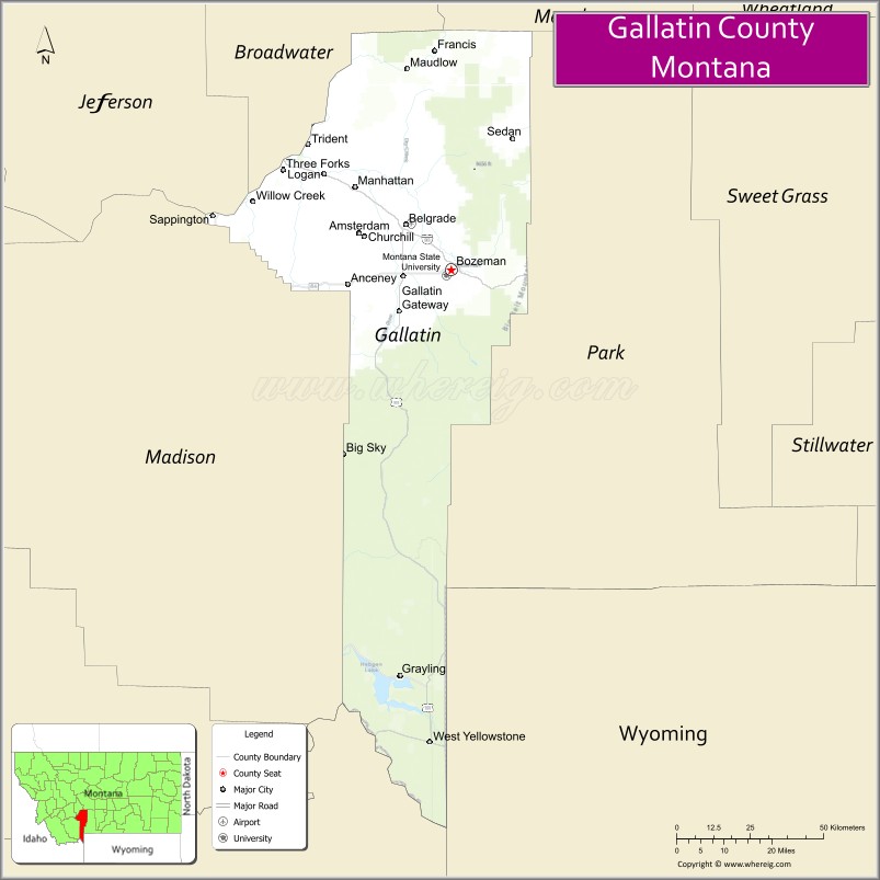
About Gallatin County Map, Montana: The map showing the county boundary, county seat, major cities, highways, water bodies and neighbouring counties.
Other Montana Maps & Info
Map of Gallatin County, Montana
Gallatin County is a county located in the U.S. state of Montana. It's county seat is Bozeman. As per 2020 census, the population of Gallatin County is 122713 people and population density is square miles. According to the United States Census Bureau, the county has a total area of 2,507 sq mi (6,493 km2). Gallatin County was established on -12749.
Gallatin County Facts
| Continent | North America |
| Country | United States |
| State | Montana |
| County Seat | Bozeman |
| Largest City/Town | Bozeman |
| Established | 1865 |
| Total Area | 2,632 sq mi (6,817 sq km) |
| Land Area | 2,605 sq mi (6,747 sq km) |
| Water Area | 27 sq mi (70 sq km) |
| Population | 118,960 (Census 2020) |
| Population Density | 45.7 people per sq mi |
| Time Zone | Mountain Time Zone (MST/MDT) |
| Major Highways | Interstate 90, U.S. Route 191, U.S. Route 287, Montana Highway 84 |
| Major Rivers | Gallatin River, Madison River, Yellowstone River |
| Neighboring Counties | Madison County, Park County, Meagher County, Broadwater County, Jefferson County |
| Famous For | Bozeman, Montana State University, Yellowstone gateway access, and mountain recreation |
| Top Attractions | Yellowstone National Park gateway, Big Sky Resort, Museum of the Rockies, and Gallatin Canyon |
| Official Website | Official Website |
About Gallatin County, Montana
Gallatin County is located in southwestern Montana in the western United States and was established in 1865. The county seat and largest city is Bozeman. The county is known for its vibrant university community, stunning Rocky Mountain scenery, outdoor recreation, ski resorts, and access to Yellowstone National Park.
Cities and Towns in Gallatin County, Montana
| City/Town | Population (Census 2020) | Latitude & Longitude |
|---|---|---|
| Bozeman (county seat) | 53,293 | 45.6770°N, 111.0429°W |
| Belgrade | 10,460 | 45.7766°N, 111.1771°W |
| Big Sky (CDP) | 3,591 | 45.2847°N, 111.4010°W |
| Manhattan | 2,117 | 45.8577°N, 111.3341°W |
| Three Forks | 1,869 | 45.8924°N, 111.5525°W |
| West Yellowstone | 1,177 | 44.6621°N, 111.1041°W |
Golf Courses in Gallatin County, Montana
| Golf Course | Location | Latitude & Longitude |
|---|---|---|
| Bridger Creek Golf Course | Bozeman | 45.6992°N, 111.0198°W |
| Big Sky Golf Course | Big Sky | 45.2795°N, 111.3942°W |
Major Roads and Highways in Gallatin County, Montana
Major highways connect the county with Yellowstone National Park and Montana’s mountain communities.
- Interstate 90 - major east-west interstate linking Bozeman with Billings and Butte
- U.S. Route 191 - scenic highway through Gallatin Canyon toward Yellowstone National Park
- U.S. Route 287 - route connecting Three Forks with Ennis and regional valleys
- Montana Highway 84 - local route serving the Gallatin Valley region
What are the Neighboring Counties of Gallatin County
- Meagher County (north)
- Broadwater County (northwest)
- Jefferson County (west)
- Madison County (southwest)
- Park County (east)
What are the top Attractions in Gallatin County, Montana
The county offers a mix of mountain recreation, university culture, and scenic natural attractions.
- Yellowstone National Park Gateway - major access point to Yellowstone through West Yellowstone
- Big Sky Resort - premier ski and mountain recreation destination
- Museum of the Rockies - renowned museum featuring dinosaur fossils and regional history exhibits
- Gallatin Canyon - scenic canyon known for rafting, hiking, and mountain views
- Montana State University - major public university in Bozeman with cultural and athletic events
- Bridger Bowl Ski Area - popular ski destination near Bozeman
- Downtown Bozeman Historic District - vibrant district with shops, restaurants, and historic architecture
- Madison Buffalo Jump State Park - Native American archaeological and cultural site
- Three Forks Missouri Headwaters State Park - historic site where the Jefferson, Madison, and Gallatin rivers meet
- Hyalite Canyon Recreation Area - mountain lake and hiking destination south of Bozeman
Distance from Gallatin County to Nearby Cities
The following distances are measured by road (driving).
- Bozeman to Big Sky (Gallatin County), Montana - 45 mi (72 km)
- Bozeman to West Yellowstone (Gallatin County), Montana - 89 mi (143 km)
- Bozeman to Billings (Yellowstone County), Montana - 142 mi (229 km)
- Bozeman to Helena (Lewis and Clark County), Montana - 96 mi (154 km)
- Bozeman to Butte (Silver Bow County), Montana - 84 mi (135 km)
- Bozeman to Livingston (Park County), Montana - 26 mi (42 km)
- Bozeman to Belgrade (Gallatin County), Montana - 11 mi (18 km)
- Bozeman to Three Forks (Gallatin County), Montana - 31 mi (50 km)
- Bozeman to Missoula (Missoula County), Montana - 201 mi (323 km)
- Bozeman to Jackson (Teton County), Wyoming - 188 mi (303 km)
- Bozeman to Salt Lake City (Salt Lake County), Utah - 389 mi (626 km)
- Bozeman to Denver (Denver County), Colorado - 553 mi (890 km)
- Bozeman to Spokane (Spokane County), Washington - 385 mi (620 km)
FAQs about Gallatin County
Gallatin County is located in southwestern Montana in the Rocky Mountain region.
Gallatin County had a population of 118,960 according to the 2020 United States Census.
Gallatin County is known for Bozeman, Yellowstone access, Montana State University, and outdoor recreation.
The county is served by Interstate 90, U.S. Route 191, U.S. Route 287, and Montana Highway 84.
Yes, Gallatin County includes golf facilities such as Bridger Creek Golf Course and Big Sky Golf Course.
References
- QuickFacts - U.S. Census Bureau
- United States Census Bureau
- United States Geological Survey (USGS)
- National Geodetic Survey
- Official Website
- Beaverhead County Map
- Big Horn County Map
- Blaine County Map
- Broadwater County Map
- Carbon County Map
- Carter County Map
- Cascade County Map
- Chouteau County Map
- Custer County Map
- Daniels County Map
- Dawson County Map
- Deer Lodge County Map
- Fallon County Map
- Fergus County Map
- Flathead County Map
- Gallatin County Map
- Garfield County Map
- Glacier County Map
- Golden Valley County Map
- Granite County Map
- Hill County Map
- Jefferson County Map
- Judith Basin County Map
- Lake County Map
- Lewis and Clark County Map
- Liberty County Map
- Lincoln County Map
- McCone County Map
- Madison County Map
- Meagher County Map
- Mineral County Map
- Missoula County Map
- Musselshell County Map
- Park County Map
- Petroleum County Map
- Phillips County Map
- Pondera County Map
- Powder River County Map
- Powell County Map
- Prairie County Map
- Ravalli County Map
- Richland County Map
- Roosevelt County Map
- Rosebud County Map
- Sanders County Map
- Sheridan County Map
- Silver Bow County Map
- Stillwater County Map
- Sweet Grass County Map
- Teton County Map
- Toole County Map
- Treasure County Map
- Valley County Map
- Wheatland County Map
- Wibaux County Map
- Yellowstone County Map
- Alabama Counties
- Alaska boroughs
- Arizona Counties
- Arkansas Counties
- California County Map
- Colorado Counties
- Connecticut Counties
- Delaware Counties
- Florida County Map
- Georgia County Map
- Hawaii Counties
- Idaho Counties
- Illinois Counties
- Indiana Counties
- Iowa Counties
- Kansas Counties
- Kentucky Counties
- Louisiana Counties
- Maine Counties
- Maryland Counties
- Massachusetts Counties
- Michigan County Map
- Minnesota Counties
- Mississippi Counties
- Missouri Counties
- Montana Counties
- Nebraska Counties
- Nevada Counties
- New York Counties
- New Hampshire Counties
- New Jersey Counties
- New Mexico Counties
- North Carolina Counties
- North Dakota Counties
- Ohio County Map
- Oklahoma Counties
- Oregon Counties
- Pennsylvania Counties
- Rhode Island Counties
- South Carolina Counties
- South Dakota Counties
- Map of Tennessee
- Texas County Map
- Utah Counties
- Vermont Counties
- Virginia Counties
- Washington Counties
- West Virginia Counties
- Wisconsin Counties
- Wyoming Counties