Map of Powder River County - Powder River County is a county located in the U.S. state of Montana. Powder River County Map showing cities, highways, important places and water bodies. Get Where is Powder River County located in the map, major cities in Powder River county, population, areas, and places of interest.
Map of Powder River County, Montana
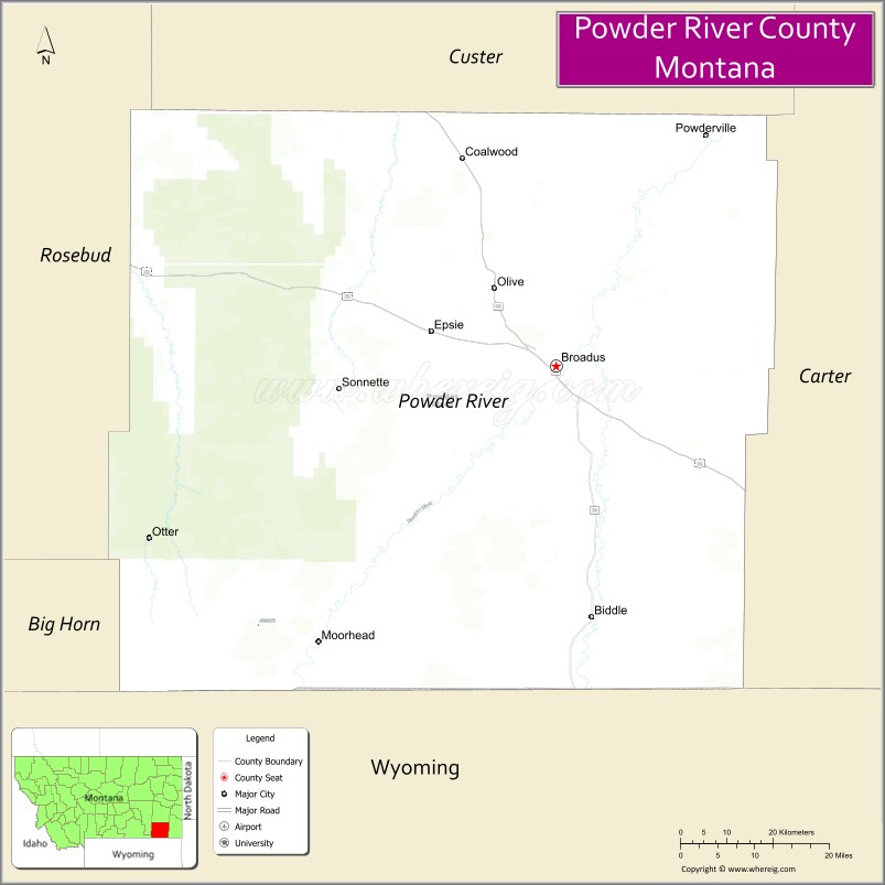
About Powder River County Map, Montana: The map showing the county boundary, county seat, major cities, highways, water bodies and neighbouring counties.
Other Montana Maps & Info
Map of Powder River County, Montana
Powder River County is a county located in the U.S. state of Montana. It's county seat is Broadus. As per 2020 census, the population of Powder River County is 1702 people and population density is square miles. According to the United States Census Bureau, the county has a total area of 3,297 sq mi (8,539 km2). Powder River County was established on 7006.
Powder River County Facts
| Continent | North America |
| Country | United States |
| State | Montana |
| County Seat | Broadus |
| Largest City/Town | Broadus |
| Established | 1919 |
| Total Area | 3,297 sq mi (8,539 sq km) |
| Land Area | 3,281 sq mi (8,498 sq km) |
| Water Area | 16 sq mi (41 sq km) |
| Population | 1,694 (Census 2020) |
| Population Density | 0.5 people per sq mi |
| Time Zone | Mountain Time Zone (MST/MDT) |
| Major Highways | U.S. Route 212, Montana Highway 59 |
| Major Rivers | Powder River, Little Powder River |
| Neighboring Counties | Custer County, Rosebud County, Carter County, Big Horn County |
| Famous For | Ranching, Powder River Basin landscapes, and western frontier heritage |
| Top Attractions | Powder River Historic Museum, Powder River Basin scenic region, Broadus historic district, and Tongue River recreation nearby region |
| Official Website | Official Website |
About Powder River County, Montana
Powder River County is located in southeastern Montana in the western United States and was established in 1919. The county seat and largest town is Broadus. The county is known for its ranching economy, open prairie landscapes, western heritage, and scenic river valleys in the Powder River Basin region.
Cities and Towns in Powder River County, Montana
| City/Town | Population (Census 2020) | Latitude & Longitude |
|---|---|---|
| Broadus (county seat) | 468 | 45.4439°N, 105.4081°W |
| Powderville | 24 | 45.6902°N, 105.0228°W |
| Biddle | 43 | 45.0935°N, 105.3074°W |
| Olive (Historic Community) | 17 | 45.6211°N, 105.6437°W |
| Boyes | 51 | 45.5208°N, 104.9954°W |
| Locate (Nearby Rural Community) | 32 | 46.4207°N, 105.0919°W |
Golf Courses in Powder River County, Montana
| Golf Course | Location | Latitude & Longitude |
|---|---|---|
| Broadus Golf Course | Broadus | 45.4495°N, 105.4142°W |
| Powder River Prairie Golf Area | Biddle | 45.0992°N, 105.3140°W |
Major Roads and Highways in Powder River County, Montana
Major highways connect the county with southeastern Montana ranching and prairie communities.
- U.S. Route 212 - major east-west highway across southeastern Montana
- Montana Highway 59 - north-south route connecting ranching regions and nearby counties
What are the Neighboring Counties of Powder River County
- Rosebud County (north)
- Custer County (northwest)
- Big Horn County (west)
- Carter County (south)
What are the top Attractions in Powder River County, Montana
The county offers a mix of prairie scenery, western heritage, and outdoor recreation.
- Powder River Historic Museum - exhibits on ranching, pioneer life, and local western history
- Powder River Basin Scenic Region - expansive prairie landscapes and river valley scenery
- Broadus Historic District - small-town western architecture and local businesses
- Tongue River Recreation nearby region - fishing, camping, and wildlife viewing opportunities
- Little Powder River Valley - scenic ranchlands and prairie drives
- Eastern Montana Prairie Scenic Routes - countryside roads through rolling plains and badlands
- Ranching Heritage Sites - attractions celebrating Montana cattle ranching culture
- Wildlife Observation Areas - habitats for deer, antelope, upland birds, and migratory wildlife
- Biddle Community Heritage Sites - historic frontier settlement attractions
- Powderville Open Range Landscapes - remote western scenery and outdoor exploration areas
Distance from Powder River County to Nearby Cities
The following distances are measured by road (driving).
- Broadus to Miles City (Custer County), Montana - 82 mi (132 km)
- Broadus to Sheridan (Sheridan County), Wyoming - 135 mi (217 km)
- Broadus to Billings (Yellowstone County), Montana - 206 mi (332 km)
- Broadus to Gillette (Campbell County), Wyoming - 168 mi (270 km)
- Broadus to Rapid City (Pennington County), South Dakota - 240 mi (386 km)
- Broadus to Biddle (Powder River County), Montana - 25 mi (40 km)
- Broadus to Powderville (Powder River County), Montana - 42 mi (68 km)
- Broadus to Bozeman (Gallatin County), Montana - 337 mi (542 km)
- Broadus to Helena (Lewis and Clark County), Montana - 361 mi (581 km)
- Broadus to Denver (Denver County), Colorado - 497 mi (800 km)
- Broadus to Bismarck (Burleigh County), North Dakota - 362 mi (583 km)
- Broadus to Spokane (Spokane County), Washington - 671 mi (1,080 km)
- Broadus to Salt Lake City (Salt Lake County), Utah - 615 mi (990 km)
FAQs about Powder River County
Powder River County is located in southeastern Montana in the Powder River Basin region.
Powder River County had a population of 1,694 according to the 2020 United States Census.
Powder River County is known for ranching, prairie scenery, western heritage, and river valley landscapes.
The county is served by U.S. Route 212 and Montana Highway 59.
Yes, Powder River County includes golf facilities such as Broadus Golf Course and prairie golf recreation areas.
References
- QuickFacts - U.S. Census Bureau
- United States Census Bureau
- United States Geological Survey (USGS)
- National Geodetic Survey
- Official Website
- Beaverhead County Map
- Big Horn County Map
- Blaine County Map
- Broadwater County Map
- Carbon County Map
- Carter County Map
- Cascade County Map
- Chouteau County Map
- Custer County Map
- Daniels County Map
- Dawson County Map
- Deer Lodge County Map
- Fallon County Map
- Fergus County Map
- Flathead County Map
- Gallatin County Map
- Garfield County Map
- Glacier County Map
- Golden Valley County Map
- Granite County Map
- Hill County Map
- Jefferson County Map
- Judith Basin County Map
- Lake County Map
- Lewis and Clark County Map
- Liberty County Map
- Lincoln County Map
- McCone County Map
- Madison County Map
- Meagher County Map
- Mineral County Map
- Missoula County Map
- Musselshell County Map
- Park County Map
- Petroleum County Map
- Phillips County Map
- Pondera County Map
- Powder River County Map
- Powell County Map
- Prairie County Map
- Ravalli County Map
- Richland County Map
- Roosevelt County Map
- Rosebud County Map
- Sanders County Map
- Sheridan County Map
- Silver Bow County Map
- Stillwater County Map
- Sweet Grass County Map
- Teton County Map
- Toole County Map
- Treasure County Map
- Valley County Map
- Wheatland County Map
- Wibaux County Map
- Yellowstone County Map
- Alabama Counties
- Alaska boroughs
- Arizona Counties
- Arkansas Counties
- California County Map
- Colorado Counties
- Connecticut Counties
- Delaware Counties
- Florida County Map
- Georgia County Map
- Hawaii Counties
- Idaho Counties
- Illinois Counties
- Indiana Counties
- Iowa Counties
- Kansas Counties
- Kentucky Counties
- Louisiana Counties
- Maine Counties
- Maryland Counties
- Massachusetts Counties
- Michigan County Map
- Minnesota Counties
- Mississippi Counties
- Missouri Counties
- Montana Counties
- Nebraska Counties
- Nevada Counties
- New York Counties
- New Hampshire Counties
- New Jersey Counties
- New Mexico Counties
- North Carolina Counties
- North Dakota Counties
- Ohio County Map
- Oklahoma Counties
- Oregon Counties
- Pennsylvania Counties
- Rhode Island Counties
- South Carolina Counties
- South Dakota Counties
- Map of Tennessee
- Texas County Map
- Utah Counties
- Vermont Counties
- Virginia Counties
- Washington Counties
- West Virginia Counties
- Wisconsin Counties
- Wyoming Counties