Map of Dawson County - Dawson County is a county located in the U.S. state of Montana. Dawson County Map showing cities, highways, important places and water bodies. Get Where is Dawson County located in the map, major cities in Dawson county, population, areas, and places of interest.
Map of Dawson County, Montana
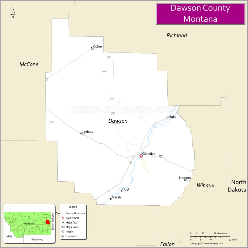
About Dawson County Map, Montana: The map showing the county boundary, county seat, major cities, highways, water bodies and neighbouring counties.
Other Montana Maps & Info
Map of Dawson County, Montana
Dawson County is a county located in the U.S. state of Montana. It's county seat is Glendive. As per 2020 census, the population of Dawson County is 8904 people and population density is square miles. According to the United States Census Bureau, the county has a total area of 2,373 sq mi (6,146 km2). Dawson County was established on -11306.
Dawson County Facts
| Continent | North America |
| Country | United States |
| State | Montana |
| County Seat | Glendive |
| Largest City/Town | Glendive |
| Established | 1869 |
| Total Area | 2,383 sq mi (6,172 sq km) |
| Land Area | 2,372 sq mi (6,143 sq km) |
| Water Area | 11 sq mi (29 sq km) |
| Population | 8,613 (Census 2020) |
| Population Density | 3.6 people per sq mi |
| Time Zone | Mountain Time Zone (MST/MDT) |
| Major Highways | Interstate 94, U.S. Route 12, Montana Highway 16 |
| Major Rivers | Yellowstone River |
| Neighboring Counties | Richland County, Prairie County, Wibaux County, McCone County, Custer County, Fallon County |
| Famous For | Makoshika State Park, dinosaur fossils, and Yellowstone River scenery |
| Top Attractions | Makoshika State Park, Glendive Dinosaur and Fossil Museum, Yellowstone River recreation, and Frontier Gateway Museum |
| Official Website | Official Website |
About Dawson County, Montana
Dawson County is located in eastern Montana in the western United States and was established in 1869. The county seat and largest city is Glendive. The county is known for its rugged badlands landscapes, rich fossil discoveries, Yellowstone River scenery, and important role in Montana railroad and frontier history.
Cities and Towns in Dawson County, Montana
| City/Town | Population (Census 2020) | Latitude & Longitude |
|---|---|---|
| Glendive (county seat) | 4,873 | 47.1053°N, 104.7125°W |
| Richey | 177 | 47.6636°N, 104.2743°W |
| Lindsay (CDP) | 35 | 47.1888°N, 104.8832°W |
| Bloomfield (CDP) | 28 | 47.3154°N, 104.8658°W |
| Stipek (Rural Community) | 16 | 47.0184°N, 104.5732°W |
| Hoyt (Rural Community) | 22 | 47.4527°N, 104.4615°W |
Golf Courses in Dawson County, Montana
| Golf Course | Location | Latitude & Longitude |
|---|---|---|
| Cottonwood Country Club | Glendive | 47.1126°N, 104.7193°W |
| Yellowstone River Golf Recreation Area | Glendive | 47.1081°N, 104.7077°W |
Major Roads and Highways in Dawson County, Montana
Major highways connect the county with eastern Montana communities and regional transportation corridors.
- Interstate 94 - major east-west interstate linking Glendive with Billings and North Dakota
- U.S. Route 12 - historic highway crossing southeastern Montana prairie landscapes
- Montana Highway 16 - north-south route connecting rural communities and agricultural regions
What are the Neighboring Counties of Dawson County
- Richland County (north)
- McCone County (northwest)
- Prairie County (west)
- Custer County (southwest)
- Fallon County (south)
- Wibaux County (east)
What are the top Attractions in Dawson County, Montana
The county offers a mix of badlands scenery, fossil history, and outdoor recreation.
- Makoshika State Park - Montana’s largest state park featuring dramatic badlands and dinosaur fossils
- Glendive Dinosaur and Fossil Museum - museum with dinosaur exhibits and paleontology displays
- Yellowstone River Recreation Areas - scenic destinations for boating, fishing, and camping
- Frontier Gateway Museum - museum showcasing local frontier, railroad, and ranching history
- Historic Bell Street Bridge - notable historic bridge crossing the Yellowstone River
- Makoshika Dinosaur Trail - hiking and interpretive trails through fossil-rich badlands
- Downtown Glendive Historic District - local shops, historic architecture, and restaurants
- Dawson County Prairie Scenic Drives - countryside routes with open rangelands and rolling hills
- Richey Community Heritage Sites - historic agricultural community attractions
- Cottonwood Creek Recreation Areas - outdoor destinations for wildlife viewing and fishing
Distance from Dawson County to Nearby Cities
The following distances are measured by road (driving).
- Glendive to Miles City (Custer County), Montana - 76 mi (122 km)
- Glendive to Sidney (Richland County), Montana - 78 mi (126 km)
- Glendive to Billings (Yellowstone County), Montana - 220 mi (354 km)
- Glendive to Dickinson (Stark County), North Dakota - 91 mi (146 km)
- Glendive to Bismarck (Burleigh County), North Dakota - 191 mi (307 km)
- Glendive to Richey (Dawson County), Montana - 39 mi (63 km)
- Glendive to Baker (Fallon County), Montana - 51 mi (82 km)
- Glendive to Williston (Williams County), North Dakota - 149 mi (240 km)
- Glendive to Rapid City (Pennington County), South Dakota - 298 mi (480 km)
- Glendive to Bozeman (Gallatin County), Montana - 364 mi (586 km)
- Glendive to Fargo (Cass County), North Dakota - 340 mi (547 km)
- Glendive to Minneapolis (Hennepin County), Minnesota - 726 mi (1,168 km)
- Glendive to Denver (Denver County), Colorado - 607 mi (977 km)
FAQs about Dawson County
Dawson County is located in eastern Montana along the Yellowstone River.
Dawson County had a population of 8,613 according to the 2020 United States Census.
Dawson County is known for Makoshika State Park, dinosaur fossils, and Yellowstone River scenery.
The county is served by Interstate 94, U.S. Route 12, and Montana Highway 16.
Yes, Dawson County includes golf facilities such as Cottonwood Country Club and recreation golf areas near the Yellowstone River.
References
- QuickFacts - U.S. Census Bureau
- United States Census Bureau
- United States Geological Survey (USGS)
- National Geodetic Survey
- Official Website
- Beaverhead County Map
- Big Horn County Map
- Blaine County Map
- Broadwater County Map
- Carbon County Map
- Carter County Map
- Cascade County Map
- Chouteau County Map
- Custer County Map
- Daniels County Map
- Dawson County Map
- Deer Lodge County Map
- Fallon County Map
- Fergus County Map
- Flathead County Map
- Gallatin County Map
- Garfield County Map
- Glacier County Map
- Golden Valley County Map
- Granite County Map
- Hill County Map
- Jefferson County Map
- Judith Basin County Map
- Lake County Map
- Lewis and Clark County Map
- Liberty County Map
- Lincoln County Map
- McCone County Map
- Madison County Map
- Meagher County Map
- Mineral County Map
- Missoula County Map
- Musselshell County Map
- Park County Map
- Petroleum County Map
- Phillips County Map
- Pondera County Map
- Powder River County Map
- Powell County Map
- Prairie County Map
- Ravalli County Map
- Richland County Map
- Roosevelt County Map
- Rosebud County Map
- Sanders County Map
- Sheridan County Map
- Silver Bow County Map
- Stillwater County Map
- Sweet Grass County Map
- Teton County Map
- Toole County Map
- Treasure County Map
- Valley County Map
- Wheatland County Map
- Wibaux County Map
- Yellowstone County Map
- Alabama Counties
- Alaska boroughs
- Arizona Counties
- Arkansas Counties
- California County Map
- Colorado Counties
- Connecticut Counties
- Delaware Counties
- Florida County Map
- Georgia County Map
- Hawaii Counties
- Idaho Counties
- Illinois Counties
- Indiana Counties
- Iowa Counties
- Kansas Counties
- Kentucky Counties
- Louisiana Counties
- Maine Counties
- Maryland Counties
- Massachusetts Counties
- Michigan County Map
- Minnesota Counties
- Mississippi Counties
- Missouri Counties
- Montana Counties
- Nebraska Counties
- Nevada Counties
- New York Counties
- New Hampshire Counties
- New Jersey Counties
- New Mexico Counties
- North Carolina Counties
- North Dakota Counties
- Ohio County Map
- Oklahoma Counties
- Oregon Counties
- Pennsylvania Counties
- Rhode Island Counties
- South Carolina Counties
- South Dakota Counties
- Map of Tennessee
- Texas County Map
- Utah Counties
- Vermont Counties
- Virginia Counties
- Washington Counties
- West Virginia Counties
- Wisconsin Counties
- Wyoming Counties