Map of Yellowstone County - Yellowstone County is a county located in the U.S. state of Montana. Yellowstone County Map showing cities, highways, important places and water bodies. Get Where is Yellowstone County located in the map, major cities in Yellowstone county, population, areas, and places of interest.
Map of Yellowstone County, Montana
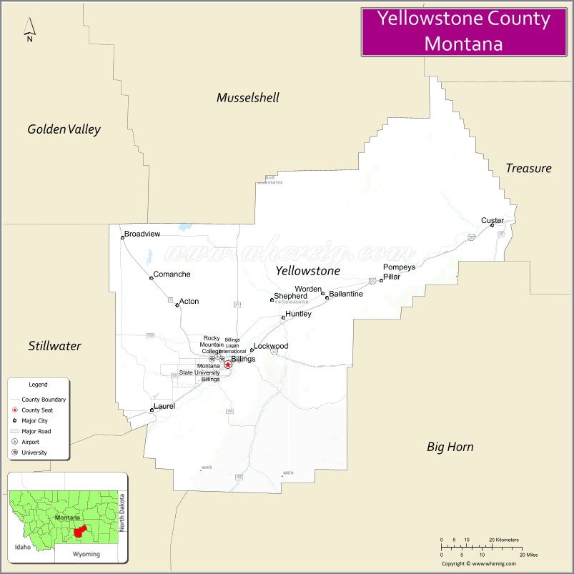
About Yellowstone County Map, Montana: The map showing the county boundary, county seat, major cities, highways, water bodies and neighbouring counties.
Other Montana Maps & Info
Map of Yellowstone County, Montana
Yellowstone County is a county located in the U.S. state of Montana. It's county seat is Billings. As per 2020 census, the population of Yellowstone County is 167146 people and population density is square miles. According to the United States Census Bureau, the county has a total area of 2,635 sq mi (6,825 km2). Yellowstone County was established on -6151.
Yellowstone County Facts
| Continent | North America |
| Country | United States |
| State | Montana |
| County Seat | Billings |
| Largest City/Town | Billings |
| Established | 1883 |
| Total Area | 2,649 sq mi (6,861 sq km) |
| Land Area | 2,633 sq mi (6,818 sq km) |
| Water Area | 16 sq mi (41 sq km) |
| Population | 164,731 (Census 2020) |
| Population Density | 62.6 people per sq mi |
| Time Zone | Mountain Time Zone (MST/MDT) |
| Major Highways | Interstate 90, Interstate 94, U.S. Route 87, U.S. Route 212 |
| Major Rivers | Yellowstone River, Bighorn River nearby region |
| Neighboring Counties | Stillwater County, Carbon County, Big Horn County, Treasure County, Musselshell County |
| Famous For | Billings metropolitan area, Yellowstone River Valley, Rimrocks scenery, and regional commerce |
| Top Attractions | Pictograph Cave State Park, ZooMontana, Yellowstone Art Museum, and Rimrocks viewpoints |
| Official Website | Official Website |
About Yellowstone County, Montana
Yellowstone County is located in south-central Montana in the western United States and was established in 1883. The county seat and largest city is Billings, which is also the largest city in Montana. The county is known for its economic importance, Yellowstone River Valley scenery, medical and business centers, outdoor recreation, and dramatic Rimrocks sandstone cliffs.
Cities and Towns in Yellowstone County, Montana
| City/Town | Population (Census 2020) | Latitude & Longitude |
|---|---|---|
| Billings (county seat) | 117,116 | 45.7833°N, 108.5007°W |
| Laurel | 6,255 | 45.6691°N, 108.7718°W |
| Lockwood | 6,250 | 45.8191°N, 108.4140°W |
| Shepherd | 1,939 | 45.9425°N, 108.3429°W |
| Huntley | 446 | 45.8994°N, 108.3112°W |
| Broadview | 192 | 46.0886°N, 108.8827°W |
Golf Courses in Yellowstone County, Montana
| Golf Course | Location | Latitude & Longitude |
|---|---|---|
| Lake Hills Golf Club | Billings | 45.7689°N, 108.5582°W |
| Yellowstone Country Club | Billings | 45.7820°N, 108.5457°W |
| Laurel Golf Club | Laurel | 45.6754°N, 108.7796°W |
Major Roads and Highways in Yellowstone County, Montana
Major highways make Yellowstone County one of the most important transportation hubs in Montana.
- Interstate 90 - major east-west interstate through southern Montana
- Interstate 94 - interstate connecting Billings with eastern Montana and North Dakota
- U.S. Route 87 - regional north-south transportation corridor
- U.S. Route 212 - scenic route linking Montana with Wyoming and South Dakota
What are the Neighboring Counties of Yellowstone County
- Musselshell County (north)
- Treasure County (east)
- Big Horn County (south)
- Carbon County (southwest)
- Stillwater County (west)
What are the top Attractions in Yellowstone County, Montana
The county offers a mix of urban attractions, outdoor recreation, and historic landmarks.
- Pictograph Cave State Park - prehistoric rock art site with hiking trails and archaeological exhibits
- ZooMontana - large wildlife park featuring native and exotic animal species
- Yellowstone Art Museum - regional art museum with contemporary and western collections
- Rimrocks Viewpoints - dramatic sandstone cliffs overlooking Billings and the Yellowstone Valley
- Moss Mansion Museum - historic mansion showcasing early 20th-century architecture
- Riverfront Park - recreation area along the Yellowstone River with trails and picnic areas
- Western Heritage Center - museum featuring Yellowstone Valley history and culture
- Billings Historic Downtown - restaurants, shopping, breweries, and cultural venues
- Pompeys Pillar National Monument nearby region - historic sandstone landmark visited by Lewis and Clark
- Yellowstone River Recreation Areas - fishing, boating, wildlife viewing, and scenic trails
Distance from Yellowstone County to Nearby Cities
The following distances are measured by road (driving).
- Billings to Bozeman (Gallatin County), Montana - 142 mi (229 km)
- Billings to Miles City (Custer County), Montana - 144 mi (232 km)
- Billings to Red Lodge (Carbon County), Montana - 62 mi (100 km)
- Billings to Sheridan (Sheridan County), Wyoming - 129 mi (208 km)
- Billings to Cody (Park County), Wyoming - 106 mi (171 km)
- Billings to Laurel (Yellowstone County), Montana - 15 mi (24 km)
- Billings to Lockwood (Yellowstone County), Montana - 5 mi (8 km)
- Billings to Helena (Lewis and Clark County), Montana - 239 mi (385 km)
- Billings to Rapid City (Pennington County), South Dakota - 316 mi (509 km)
- Billings to Missoula (Missoula County), Montana - 340 mi (547 km)
- Billings to Denver (Denver County), Colorado - 555 mi (893 km)
- Billings to Salt Lake City (Salt Lake County), Utah - 555 mi (893 km)
- Billings to Minneapolis (Hennepin County), Minnesota - 890 mi (1,432 km)
FAQs about Yellowstone County
Yellowstone County is located in south-central Montana along the Yellowstone River Valley.
Yellowstone County had a population of 164,731 according to the 2020 United States Census.
Yellowstone County is known for Billings, the Yellowstone River, Rimrocks scenery, and regional commerce.
The county is served by Interstate 90, Interstate 94, U.S. Route 87, and U.S. Route 212.
Yes, Yellowstone County includes golf facilities such as Lake Hills Golf Club, Yellowstone Country Club, and Laurel Golf Club.
References
- QuickFacts - U.S. Census Bureau
- United States Census Bureau
- United States Geological Survey (USGS)
- National Geodetic Survey
- Official Website
- Beaverhead County Map
- Big Horn County Map
- Blaine County Map
- Broadwater County Map
- Carbon County Map
- Carter County Map
- Cascade County Map
- Chouteau County Map
- Custer County Map
- Daniels County Map
- Dawson County Map
- Deer Lodge County Map
- Fallon County Map
- Fergus County Map
- Flathead County Map
- Gallatin County Map
- Garfield County Map
- Glacier County Map
- Golden Valley County Map
- Granite County Map
- Hill County Map
- Jefferson County Map
- Judith Basin County Map
- Lake County Map
- Lewis and Clark County Map
- Liberty County Map
- Lincoln County Map
- McCone County Map
- Madison County Map
- Meagher County Map
- Mineral County Map
- Missoula County Map
- Musselshell County Map
- Park County Map
- Petroleum County Map
- Phillips County Map
- Pondera County Map
- Powder River County Map
- Powell County Map
- Prairie County Map
- Ravalli County Map
- Richland County Map
- Roosevelt County Map
- Rosebud County Map
- Sanders County Map
- Sheridan County Map
- Silver Bow County Map
- Stillwater County Map
- Sweet Grass County Map
- Teton County Map
- Toole County Map
- Treasure County Map
- Valley County Map
- Wheatland County Map
- Wibaux County Map
- Yellowstone County Map
- Alabama Counties
- Alaska boroughs
- Arizona Counties
- Arkansas Counties
- California County Map
- Colorado Counties
- Connecticut Counties
- Delaware Counties
- Florida County Map
- Georgia County Map
- Hawaii Counties
- Idaho Counties
- Illinois Counties
- Indiana Counties
- Iowa Counties
- Kansas Counties
- Kentucky Counties
- Louisiana Counties
- Maine Counties
- Maryland Counties
- Massachusetts Counties
- Michigan County Map
- Minnesota Counties
- Mississippi Counties
- Missouri Counties
- Montana Counties
- Nebraska Counties
- Nevada Counties
- New York Counties
- New Hampshire Counties
- New Jersey Counties
- New Mexico Counties
- North Carolina Counties
- North Dakota Counties
- Ohio County Map
- Oklahoma Counties
- Oregon Counties
- Pennsylvania Counties
- Rhode Island Counties
- South Carolina Counties
- South Dakota Counties
- Map of Tennessee
- Texas County Map
- Utah Counties
- Vermont Counties
- Virginia Counties
- Washington Counties
- West Virginia Counties
- Wisconsin Counties
- Wyoming Counties