Map of Toole County - Toole County is a county located in the U.S. state of Montana. Toole County Map showing cities, highways, important places and water bodies. Get Where is Toole County located in the map, major cities in Toole county, population, areas, and places of interest.
Map of Toole County, Montana
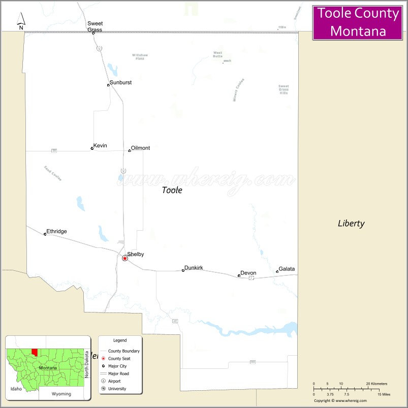
About Toole County Map, Montana: The map showing the county boundary, county seat, major cities, highways, water bodies and neighbouring counties.
Other Montana Maps & Info
Map of Toole County, Montana
Toole County is a county located in the U.S. state of Montana. It's county seat is Shelby. As per 2020 census, the population of Toole County is 5011 people and population density is square miles. According to the United States Census Bureau, the county has a total area of 1,911 sq mi (4,949 km2). Toole County was established on 5241.
Toole County Facts
| Continent | North America |
| Country | United States |
| State | Montana |
| County Seat | Shelby |
| Largest City/Town | Shelby |
| Established | 1914 |
| Total Area | 1,946 sq mi (5,040 sq km) |
| Land Area | 1,916 sq mi (4,962 sq km) |
| Water Area | 30 sq mi (78 sq km) |
| Population | 4,971 (Census 2020) |
| Population Density | 2.6 people per sq mi |
| Time Zone | Mountain Time Zone (MST/MDT) |
| Major Highways | Interstate 15, U.S. Route 2, Montana Highway 44 |
| Major Rivers | Marias River, Milk River nearby region |
| Neighboring Counties | Liberty County, Glacier County, Pondera County |
| Famous For | Prairie agriculture, Canadian border access, oil production, and northern Montana rail history |
| Top Attractions | Marias Museum of History and Art, Sweetgrass Hills nearby region, Shelby historic district, and Lake Shel-oole recreation area |
| Official Website | Official Website |
About Toole County, Montana
Toole County is located in north-central Montana in the western United States and was established in 1914. The county seat and largest city is Shelby. The county is known for its agricultural economy, railroad heritage, open prairie landscapes, oil production, and proximity to the Canadian border.
Cities and Towns in Toole County, Montana
| City/Town | Population (Census 2020) | Latitude & Longitude |
|---|---|---|
| Shelby (county seat) | 3,140 | 48.5053°N, 111.8569°W |
| Sunburst | 333 | 48.8833°N, 111.9094°W |
| Kevin | 154 | 48.7480°N, 111.9475°W |
| Sweet Grass | 65 | 48.9971°N, 111.9597°W |
| Ethridge | 82 | 48.5639°N, 112.1048°W |
| Galata | 39 | 48.5795°N, 111.3652°W |
Golf Courses in Toole County, Montana
| Golf Course | Location | Latitude & Longitude |
|---|---|---|
| Marias Valley Golf & Country Club | Shelby | 48.5118°N, 111.8634°W |
| Sunburst Prairie Golf Area | Sunburst | 48.8894°N, 111.9158°W |
Major Roads and Highways in Toole County, Montana
Major highways connect the county with northern Montana agricultural communities and Canadian border crossings.
- Interstate 15 - major north-south interstate linking Montana with Canada and Idaho
- U.S. Route 2 - important east-west highway across northern Montana
- Montana Highway 44 - regional highway serving prairie communities
What are the Neighboring Counties of Toole County
- Liberty County (east)
- Glacier County (west)
- Pondera County (south)
What are the top Attractions in Toole County, Montana
The county offers a mix of prairie landscapes, local history, and northern Montana recreation.
- Marias Museum of History and Art - museum featuring local heritage, railroads, and regional history
- Sweetgrass Hills nearby region - isolated mountain buttes rising above the northern plains
- Shelby Historic District - downtown western architecture and railroad heritage sites
- Lake Shel-oole Recreation Area - boating, fishing, and camping destination
- Prairie Scenic Drives - countryside routes through open farmland and ranchlands
- Sweet Grass Border Crossing Area - important gateway between Montana and Alberta
- Sunburst Oil Heritage Sites - attractions linked to Montana oil industry history
- Ethridge Farming Region - scenic agricultural landscapes and prairie views
- Wildlife Observation Areas - habitats for migratory birds, deer, and prairie wildlife
- Northern Montana Railroad History Sites - preserved reminders of early transportation routes
Distance from Toole County to Nearby Cities
The following distances are measured by road (driving).
- Shelby to Cut Bank (Glacier County), Montana - 35 mi (56 km)
- Shelby to Great Falls (Cascade County), Montana - 89 mi (143 km)
- Shelby to Conrad (Pondera County), Montana - 32 mi (51 km)
- Shelby to Havre (Hill County), Montana - 115 mi (185 km)
- Shelby to Helena (Lewis and Clark County), Montana - 177 mi (285 km)
- Shelby to Sunburst (Toole County), Montana - 25 mi (40 km)
- Shelby to Kevin (Toole County), Montana - 16 mi (26 km)
- Shelby to Kalispell (Flathead County), Montana - 126 mi (203 km)
- Shelby to Missoula (Missoula County), Montana - 251 mi (404 km)
- Shelby to Calgary, Alberta - 146 mi (235 km)
- Shelby to Bozeman (Gallatin County), Montana - 255 mi (410 km)
- Shelby to Spokane (Spokane County), Washington - 458 mi (737 km)
- Shelby to Denver (Denver County), Colorado - 790 mi (1,271 km)
FAQs about Toole County
Toole County is located in north-central Montana near the Canadian border.
Toole County had a population of 4,971 according to the 2020 United States Census.
Toole County is known for agriculture, railroad heritage, oil production, and prairie landscapes.
The county is served by Interstate 15, U.S. Route 2, and Montana Highway 44.
Yes, Toole County includes golf facilities such as Marias Valley Golf & Country Club and Sunburst Prairie Golf Area.
References
- QuickFacts - U.S. Census Bureau
- United States Census Bureau
- United States Geological Survey (USGS)
- National Geodetic Survey
- Official Website
- Beaverhead County Map
- Big Horn County Map
- Blaine County Map
- Broadwater County Map
- Carbon County Map
- Carter County Map
- Cascade County Map
- Chouteau County Map
- Custer County Map
- Daniels County Map
- Dawson County Map
- Deer Lodge County Map
- Fallon County Map
- Fergus County Map
- Flathead County Map
- Gallatin County Map
- Garfield County Map
- Glacier County Map
- Golden Valley County Map
- Granite County Map
- Hill County Map
- Jefferson County Map
- Judith Basin County Map
- Lake County Map
- Lewis and Clark County Map
- Liberty County Map
- Lincoln County Map
- McCone County Map
- Madison County Map
- Meagher County Map
- Mineral County Map
- Missoula County Map
- Musselshell County Map
- Park County Map
- Petroleum County Map
- Phillips County Map
- Pondera County Map
- Powder River County Map
- Powell County Map
- Prairie County Map
- Ravalli County Map
- Richland County Map
- Roosevelt County Map
- Rosebud County Map
- Sanders County Map
- Sheridan County Map
- Silver Bow County Map
- Stillwater County Map
- Sweet Grass County Map
- Teton County Map
- Toole County Map
- Treasure County Map
- Valley County Map
- Wheatland County Map
- Wibaux County Map
- Yellowstone County Map
- Alabama Counties
- Alaska boroughs
- Arizona Counties
- Arkansas Counties
- California County Map
- Colorado Counties
- Connecticut Counties
- Delaware Counties
- Florida County Map
- Georgia County Map
- Hawaii Counties
- Idaho Counties
- Illinois Counties
- Indiana Counties
- Iowa Counties
- Kansas Counties
- Kentucky Counties
- Louisiana Counties
- Maine Counties
- Maryland Counties
- Massachusetts Counties
- Michigan County Map
- Minnesota Counties
- Mississippi Counties
- Missouri Counties
- Montana Counties
- Nebraska Counties
- Nevada Counties
- New York Counties
- New Hampshire Counties
- New Jersey Counties
- New Mexico Counties
- North Carolina Counties
- North Dakota Counties
- Ohio County Map
- Oklahoma Counties
- Oregon Counties
- Pennsylvania Counties
- Rhode Island Counties
- South Carolina Counties
- South Dakota Counties
- Map of Tennessee
- Texas County Map
- Utah Counties
- Vermont Counties
- Virginia Counties
- Washington Counties
- West Virginia Counties
- Wisconsin Counties
- Wyoming Counties