Map of Missoula County - Missoula County is a county located in the U.S. state of Montana. Missoula County Map showing cities, highways, important places and water bodies. Get Where is Missoula County located in the map, major cities in Missoula county, population, areas, and places of interest.
Map of Missoula County, Montana
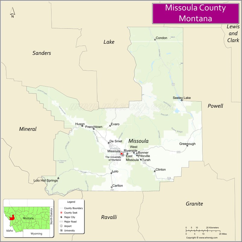
About Missoula County Map, Montana: The map showing the county boundary, county seat, major cities, highways, water bodies and neighbouring counties.
Other Montana Maps & Info
Map of Missoula County, Montana
Missoula County is a county located in the U.S. state of Montana. It's county seat is Missoula. As per 2020 census, the population of Missoula County is 119533 people and population density is square miles. According to the United States Census Bureau, the county has a total area of 2,598 sq mi (6,729 km2). Missoula County was established on -12749.
Missoula County Facts
| Continent | North America |
| Country | United States |
| State | Montana |
| County Seat | Missoula |
| Largest City/Town | Missoula |
| Established | 1860 |
| Total Area | 2,618 sq mi (6,781 sq km) |
| Land Area | 2,593 sq mi (6,716 sq km) |
| Water Area | 25 sq mi (65 sq km) |
| Population | 117,922 (Census 2020) |
| Population Density | 45.5 people per sq mi |
| Time Zone | Mountain Time Zone (MST/MDT) |
| Major Highways | Interstate 90, U.S. Route 12, U.S. Route 93 |
| Major Rivers | Clark Fork River, Bitterroot River, Blackfoot River |
| Neighboring Counties | Mineral County, Sanders County, Ravalli County, Granite County, Powell County, Lake County |
| Famous For | University of Montana, outdoor recreation, rivers, and vibrant arts culture |
| Top Attractions | University of Montana, Caras Park, Rattlesnake National Recreation Area, and Clark Fork Riverfront Trail |
| Official Website | Official Website |
About Missoula County, Montana
Missoula County is located in western Montana in the western United States and was established in 1860. The county seat and largest city is Missoula. The county is known for its university culture, scenic river valleys, mountain recreation, arts community, and strong connection to outdoor adventure tourism.
Cities and Towns in Missoula County, Montana
| City/Town | Population (Census 2020) | Latitude & Longitude |
|---|---|---|
| Missoula (county seat) | 73,489 | 46.8721°N, 113.9940°W |
| East Missoula (CDP) | 2,157 | 46.8696°N, 113.9365°W |
| Lolo (CDP) | 3,892 | 46.7585°N, 114.0804°W |
| Bonner-West Riverside (CDP) | 1,663 | 46.8729°N, 113.8846°W |
| Seeley Lake (CDP) | 1,761 | 47.1785°N, 113.4840°W |
| Clinton (CDP) | 1,052 | 46.7699°N, 113.7123°W |
Golf Courses in Missoula County, Montana
| Golf Course | Location | Latitude & Longitude |
|---|---|---|
| University Golf Course | Missoula | 46.8614°N, 113.9783°W |
| Highland Golf Club | Missoula | 46.8448°N, 114.0217°W |
Major Roads and Highways in Missoula County, Montana
Major highways connect the county with western Montana mountain valleys and regional cities.
- Interstate 90 - major east-west interstate through western Montana
- U.S. Route 12 - scenic highway linking Missoula with Idaho and central Montana
- U.S. Route 93 - north-south highway connecting the Bitterroot Valley and Flathead region
What are the Neighboring Counties of Missoula County
- Lake County (north)
- Sanders County (northwest)
- Mineral County (west)
- Ravalli County (south)
- Granite County (southeast)
- Powell County (east)
What are the top Attractions in Missoula County, Montana
The county offers a mix of outdoor recreation, cultural attractions, and scenic riverfront destinations.
- University of Montana - major public university with museums, sports, and cultural events
- Caras Park - downtown riverfront park hosting concerts, festivals, and public gatherings
- Rattlesnake National Recreation Area - hiking and wilderness recreation near Missoula
- Clark Fork Riverfront Trail - scenic trail system along the river through downtown Missoula
- Missoula Art Museum - contemporary art museum featuring regional artists and exhibitions
- Blue Mountain Recreation Area - hiking, biking, and outdoor recreation destination
- Seeley Lake Recreation Region - boating, fishing, and forest recreation area
- Historical Museum at Fort Missoula - exhibits on regional history and military heritage
- Bitterroot Valley Scenic Routes nearby region - mountain landscapes and outdoor recreation access
- Montana Snowbowl - ski area and winter recreation destination near Missoula
Distance from Missoula County to Nearby Cities
The following distances are measured by road (driving).
- Missoula to Kalispell (Flathead County), Montana - 121 mi (195 km)
- Missoula to Helena (Lewis and Clark County), Montana - 112 mi (180 km)
- Missoula to Butte (Silver Bow County), Montana - 119 mi (192 km)
- Missoula to Bozeman (Gallatin County), Montana - 202 mi (325 km)
- Missoula to Spokane (Spokane County), Washington - 200 mi (322 km)
- Missoula to Coeur d'Alene (Kootenai County), Idaho - 138 mi (222 km)
- Missoula to Seattle (King County), Washington - 474 mi (763 km)
- Missoula to Salt Lake City (Salt Lake County), Utah - 522 mi (840 km)
- Missoula to Billings (Yellowstone County), Montana - 340 mi (547 km)
- Missoula to Denver (Denver County), Colorado - 751 mi (1,209 km)
- Missoula to Calgary, Alberta - 385 mi (620 km)
- Missoula to Portland (Multnomah County), Oregon - 548 mi (882 km)
- Missoula to East Missoula (Missoula County), Montana - 3 mi (5 km)
FAQs about Missoula County
Missoula County is located in western Montana in the Northern Rocky Mountains region.
Missoula County had a population of 117,922 according to the 2020 United States Census.
Missoula County is known for the University of Montana, outdoor recreation, rivers, and its arts and culture scene.
The county is served by Interstate 90, U.S. Route 12, and U.S. Route 93.
Yes, Missoula County includes golf facilities such as University Golf Course and Highland Golf Club.
References
- QuickFacts - U.S. Census Bureau
- United States Census Bureau
- United States Geological Survey (USGS)
- National Geodetic Survey
- Official Website
- Beaverhead County Map
- Big Horn County Map
- Blaine County Map
- Broadwater County Map
- Carbon County Map
- Carter County Map
- Cascade County Map
- Chouteau County Map
- Custer County Map
- Daniels County Map
- Dawson County Map
- Deer Lodge County Map
- Fallon County Map
- Fergus County Map
- Flathead County Map
- Gallatin County Map
- Garfield County Map
- Glacier County Map
- Golden Valley County Map
- Granite County Map
- Hill County Map
- Jefferson County Map
- Judith Basin County Map
- Lake County Map
- Lewis and Clark County Map
- Liberty County Map
- Lincoln County Map
- McCone County Map
- Madison County Map
- Meagher County Map
- Mineral County Map
- Missoula County Map
- Musselshell County Map
- Park County Map
- Petroleum County Map
- Phillips County Map
- Pondera County Map
- Powder River County Map
- Powell County Map
- Prairie County Map
- Ravalli County Map
- Richland County Map
- Roosevelt County Map
- Rosebud County Map
- Sanders County Map
- Sheridan County Map
- Silver Bow County Map
- Stillwater County Map
- Sweet Grass County Map
- Teton County Map
- Toole County Map
- Treasure County Map
- Valley County Map
- Wheatland County Map
- Wibaux County Map
- Yellowstone County Map
- Alabama Counties
- Alaska boroughs
- Arizona Counties
- Arkansas Counties
- California County Map
- Colorado Counties
- Connecticut Counties
- Delaware Counties
- Florida County Map
- Georgia County Map
- Hawaii Counties
- Idaho Counties
- Illinois Counties
- Indiana Counties
- Iowa Counties
- Kansas Counties
- Kentucky Counties
- Louisiana Counties
- Maine Counties
- Maryland Counties
- Massachusetts Counties
- Michigan County Map
- Minnesota Counties
- Mississippi Counties
- Missouri Counties
- Montana Counties
- Nebraska Counties
- Nevada Counties
- New York Counties
- New Hampshire Counties
- New Jersey Counties
- New Mexico Counties
- North Carolina Counties
- North Dakota Counties
- Ohio County Map
- Oklahoma Counties
- Oregon Counties
- Pennsylvania Counties
- Rhode Island Counties
- South Carolina Counties
- South Dakota Counties
- Map of Tennessee
- Texas County Map
- Utah Counties
- Vermont Counties
- Virginia Counties
- Washington Counties
- West Virginia Counties
- Wisconsin Counties
- Wyoming Counties