Map of Sweet Grass County - Sweet Grass County is a county located in the U.S. state of Montana. Sweet Grass County Map showing cities, highways, important places and water bodies. Get Where is Sweet Grass County located in the map, major cities in Sweet Grass county, population, areas, and places of interest.
Map of Sweet Grass County, Montana
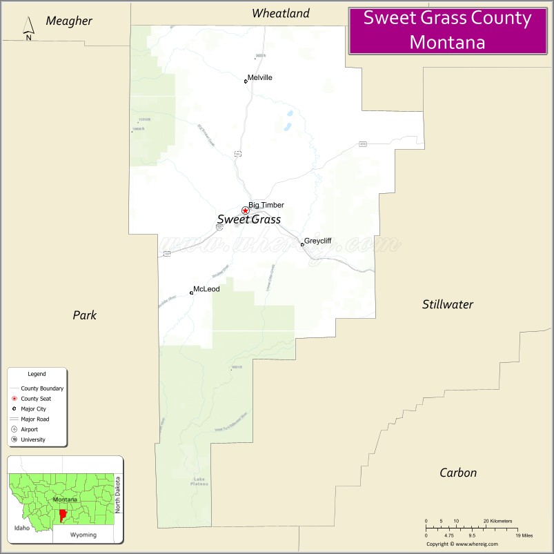
About Sweet Grass County Map, Montana: The map showing the county boundary, county seat, major cities, highways, water bodies and neighbouring counties.
Other Montana Maps & Info
Map of Sweet Grass County, Montana
Sweet Grass County is a county located in the U.S. state of Montana. It's county seat is Big Timber. As per 2020 census, the population of Sweet Grass County is 3723 people and population density is square miles. According to the United States Census Bureau, the county has a total area of 1,855 sq mi (4,804 km2). Sweet Grass County was established on -1761.
Sweet Grass County Facts
| Continent | North America |
| Country | United States |
| State | Montana |
| County Seat | Big Timber |
| Largest City/Town | Big Timber |
| Established | 1895 |
| Total Area | 1,862 sq mi (4,823 sq km) |
| Land Area | 1,855 sq mi (4,805 sq km) |
| Water Area | 7 sq mi (18 sq km) |
| Population | 3,737 (Census 2020) |
| Population Density | 2.0 people per sq mi |
| Time Zone | Mountain Time Zone (MST/MDT) |
| Major Highways | Interstate 90, U.S. Route 191 |
| Major Rivers | Yellowstone River, Sweet Grass Creek |
| Neighboring Counties | Park County, Stillwater County, Wheatland County, Meagher County |
| Famous For | Crazy Mountains scenery, ranching, fly fishing, and Yellowstone River Valley |
| Top Attractions | Crazy Mountains nearby region, Yellowstone River recreation, Big Timber historic district, and Sweet Grass Canyon |
| Official Website | Official Website |
About Sweet Grass County, Montana
Sweet Grass County is located in south-central Montana in the western United States and was established in 1895. The county seat and largest town is Big Timber. The county is known for its scenic ranchlands, mountain recreation, fly fishing streams, Yellowstone River Valley, and access to the Crazy Mountains.
Cities and Towns in Sweet Grass County, Montana
| City/Town | Population (Census 2020) | Latitude & Longitude |
|---|---|---|
| Big Timber (county seat) | 1,650 | 45.8341°N, 109.9510°W |
| Melville | 112 | 46.1047°N, 110.0705°W |
| Grey Cliff | 98 | 45.7830°N, 109.7858°W |
| McLeod | 156 | 45.8498°N, 110.1425°W |
| Springdale | 95 | 45.7492°N, 110.2453°W |
| Reed Point (Nearby Community) | 110 | 45.7063°N, 109.5442°W |
Golf Courses in Sweet Grass County, Montana
| Golf Course | Location | Latitude & Longitude |
|---|---|---|
| Big Timber Golf Course | Big Timber | 45.8407°N, 109.9583°W |
| Yellowstone Valley Golf Recreation Area | Grey Cliff | 45.7894°N, 109.7927°W |
Major Roads and Highways in Sweet Grass County, Montana
Major highways connect the county with south-central Montana ranching communities and mountain recreation areas.
- Interstate 90 - major east-west interstate through southern Montana
- U.S. Route 191 - scenic highway linking mountain valleys and outdoor recreation regions
What are the Neighboring Counties of Sweet Grass County
- Wheatland County (north)
- Meagher County (northwest)
- Park County (west)
- Stillwater County (east)
What are the top Attractions in Sweet Grass County, Montana
The county offers a mix of mountain scenery, river recreation, and western ranching culture.
- Crazy Mountains nearby region - dramatic mountain range with hiking and wilderness recreation
- Yellowstone River Recreation Areas - fishing, boating, and wildlife viewing destinations
- Big Timber Historic District - western-style downtown with museums and local shops
- Sweet Grass Canyon - scenic mountain valley with camping and hiking access
- McLeod Area Recreation - gateway to mountain trails and fly fishing streams
- Sweet Grass Creek - popular trout fishing and scenic recreation stream
- Crazy Mountain Museum - local history museum featuring ranching and pioneer heritage
- Scenic Ranchland Drives - panoramic countryside routes through valleys and open plains
- Grey Cliff Prairie Landscapes - views of the Yellowstone River Valley and nearby mountains
- South-Central Montana Wildlife Areas - habitats for deer, elk, antelope, and upland birds
Distance from Sweet Grass County to Nearby Cities
The following distances are measured by road (driving).
- Big Timber to Livingston (Park County), Montana - 39 mi (63 km)
- Big Timber to Billings (Yellowstone County), Montana - 82 mi (132 km)
- Big Timber to Bozeman (Gallatin County), Montana - 82 mi (132 km)
- Big Timber to Columbus (Stillwater County), Montana - 39 mi (63 km)
- Big Timber to Melville (Sweet Grass County), Montana - 20 mi (32 km)
- Big Timber to McLeod (Sweet Grass County), Montana - 15 mi (24 km)
- Big Timber to Red Lodge (Carbon County), Montana - 94 mi (151 km)
- Big Timber to Cody (Park County), Wyoming - 152 mi (245 km)
- Big Timber to Helena (Lewis and Clark County), Montana - 170 mi (274 km)
- Big Timber to Missoula (Missoula County), Montana - 277 mi (446 km)
- Big Timber to Rapid City (Pennington County), South Dakota - 376 mi (605 km)
- Big Timber to Denver (Denver County), Colorado - 565 mi (909 km)
- Big Timber to Salt Lake City (Salt Lake County), Utah - 513 mi (826 km)
FAQs about Sweet Grass County
Sweet Grass County is located in south-central Montana near the Yellowstone River and Crazy Mountains.
Sweet Grass County had a population of 3,737 according to the 2020 United States Census.
Sweet Grass County is known for ranching, mountain scenery, fly fishing, and Yellowstone River recreation.
The county is served by Interstate 90 and U.S. Route 191.
Yes, Sweet Grass County includes golf facilities such as Big Timber Golf Course and Yellowstone Valley Golf Recreation Area.
References
- QuickFacts - U.S. Census Bureau
- United States Census Bureau
- United States Geological Survey (USGS)
- National Geodetic Survey
- Official Website
- Beaverhead County Map
- Big Horn County Map
- Blaine County Map
- Broadwater County Map
- Carbon County Map
- Carter County Map
- Cascade County Map
- Chouteau County Map
- Custer County Map
- Daniels County Map
- Dawson County Map
- Deer Lodge County Map
- Fallon County Map
- Fergus County Map
- Flathead County Map
- Gallatin County Map
- Garfield County Map
- Glacier County Map
- Golden Valley County Map
- Granite County Map
- Hill County Map
- Jefferson County Map
- Judith Basin County Map
- Lake County Map
- Lewis and Clark County Map
- Liberty County Map
- Lincoln County Map
- McCone County Map
- Madison County Map
- Meagher County Map
- Mineral County Map
- Missoula County Map
- Musselshell County Map
- Park County Map
- Petroleum County Map
- Phillips County Map
- Pondera County Map
- Powder River County Map
- Powell County Map
- Prairie County Map
- Ravalli County Map
- Richland County Map
- Roosevelt County Map
- Rosebud County Map
- Sanders County Map
- Sheridan County Map
- Silver Bow County Map
- Stillwater County Map
- Sweet Grass County Map
- Teton County Map
- Toole County Map
- Treasure County Map
- Valley County Map
- Wheatland County Map
- Wibaux County Map
- Yellowstone County Map
- Alabama Counties
- Alaska boroughs
- Arizona Counties
- Arkansas Counties
- California County Map
- Colorado Counties
- Connecticut Counties
- Delaware Counties
- Florida County Map
- Georgia County Map
- Hawaii Counties
- Idaho Counties
- Illinois Counties
- Indiana Counties
- Iowa Counties
- Kansas Counties
- Kentucky Counties
- Louisiana Counties
- Maine Counties
- Maryland Counties
- Massachusetts Counties
- Michigan County Map
- Minnesota Counties
- Mississippi Counties
- Missouri Counties
- Montana Counties
- Nebraska Counties
- Nevada Counties
- New York Counties
- New Hampshire Counties
- New Jersey Counties
- New Mexico Counties
- North Carolina Counties
- North Dakota Counties
- Ohio County Map
- Oklahoma Counties
- Oregon Counties
- Pennsylvania Counties
- Rhode Island Counties
- South Carolina Counties
- South Dakota Counties
- Map of Tennessee
- Texas County Map
- Utah Counties
- Vermont Counties
- Virginia Counties
- Washington Counties
- West Virginia Counties
- Wisconsin Counties
- Wyoming Counties