Map of Garfield County - Garfield County is a county located in the U.S. state of Montana. Garfield County Map showing cities, highways, important places and water bodies. Get Where is Garfield County located in the map, major cities in Garfield county, population, areas, and places of interest.
Map of Garfield County, Montana
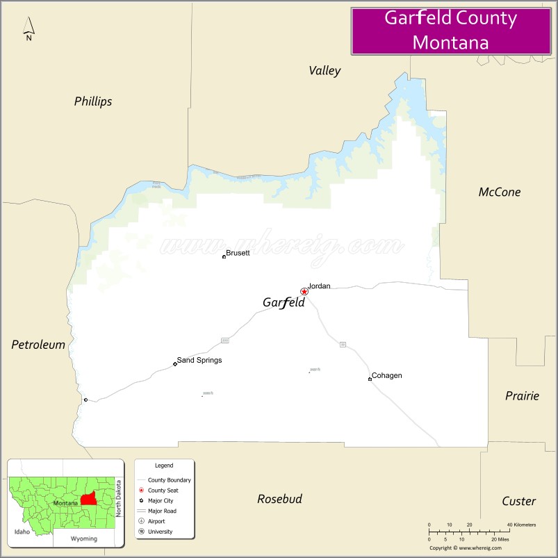
About Garfield County Map, Montana: The map showing the county boundary, county seat, major cities, highways, water bodies and neighbouring counties.
Other Montana Maps & Info
Map of Garfield County, Montana
Garfield County is a county located in the U.S. state of Montana. It's county seat is Jordan. As per 2020 census, the population of Garfield County is 1209 people and population density is square miles. According to the United States Census Bureau, the county has a total area of 4,668 sq mi (12,090 km2). Garfield County was established on 6978.
Garfield County Facts
| Continent | North America |
| Country | United States |
| State | Montana |
| County Seat | Jordan |
| Largest City/Town | Jordan |
| Established | 1919 |
| Total Area | 4,675 sq mi (12,108 sq km) |
| Land Area | 4,668 sq mi (12,090 sq km) |
| Water Area | 7 sq mi (18 sq km) |
| Population | 1,173 (Census 2020) |
| Population Density | 0.3 people per sq mi |
| Time Zone | Mountain Time Zone (MST/MDT) |
| Major Highways | Montana Highway 200, Montana Highway 59 |
| Major Rivers | Musselshell River, Missouri River |
| Neighboring Counties | Phillips County, Petroleum County, Fergus County, McCone County, Prairie County, Rosebud County |
| Famous For | Missouri River Breaks, remote prairie landscapes, and ranching heritage |
| Top Attractions | Missouri River Breaks, Hell Creek Recreation Area, Garfield County Museum, and Jordan downtown district |
| Official Website | Official Website |
About Garfield County, Montana
Garfield County is located in eastern Montana in the western United States and was established in 1919. The county seat and largest town is Jordan. The county is known for its vast prairie landscapes, ranching traditions, scenic Missouri River Breaks region, and fossil-rich badlands terrain.
Cities and Towns in Garfield County, Montana
| City/Town | Population (Census 2020) | Latitude & Longitude |
|---|---|---|
| Jordan (county seat) | 356 | 47.3200°N, 106.9106°W |
| Mosby (CDP) | 43 | 47.0047°N, 107.8808°W |
| Sand Springs (CDP) | 81 | 47.1015°N, 106.7751°W |
| Brusett (Rural Community) | 27 | 47.2134°N, 107.4125°W |
| Van Norman (Rural Community) | 19 | 47.4913°N, 106.6649°W |
| Ridgelawn (Rural Community) | 15 | 47.4028°N, 107.0214°W |
Golf Courses in Garfield County, Montana
| Golf Course | Location | Latitude & Longitude |
|---|---|---|
| Jordan Golf Course | Jordan | 47.3245°N, 106.9168°W |
| Garfield County Prairie Golf Recreation Area | Jordan | 47.3181°N, 106.9092°W |
Major Roads and Highways in Garfield County, Montana
Major highways connect the county with eastern Montana ranching and prairie communities.
- Montana Highway 200 - important east-west highway crossing central and eastern Montana
- Montana Highway 59 - north-south route connecting Jordan with Miles City and Fort Peck regions
What are the Neighboring Counties of Garfield County
- Phillips County (north)
- McCone County (northeast)
- Prairie County (east)
- Rosebud County (south)
- Petroleum County (west)
- Fergus County (southwest)
What are the top Attractions in Garfield County, Montana
The county offers a mix of remote prairie scenery, river recreation, and western heritage.
- Missouri River Breaks - rugged badlands and river canyon landscapes with wildlife viewing opportunities
- Hell Creek Recreation Area - fossil-rich region associated with dinosaur discoveries and outdoor recreation
- Garfield County Museum - local history museum featuring ranching, frontier, and Native American exhibits
- Jordan Historic Downtown - traditional prairie town center with historic buildings and local businesses
- CM Russell National Wildlife Refuge nearby region - wildlife habitat for elk, deer, and migratory birds
- Musselshell River Recreation Areas - fishing, camping, and boating destinations
- Prairie Scenic Drives - remote countryside routes featuring rolling plains and ranchlands
- Hell Creek Dinosaur Region - famous paleontological area known for dinosaur fossils
- Sand Springs Recreation Area - outdoor destination with prairie and badlands scenery
- Missouri Breaks Backcountry Trails - hiking and exploration routes through remote landscapes
Distance from Garfield County to Nearby Cities
The following distances are measured by road (driving).
- Jordan to Miles City (Custer County), Montana - 86 mi (138 km)
- Jordan to Lewistown (Fergus County), Montana - 127 mi (204 km)
- Jordan to Glasgow (Valley County), Montana - 141 mi (227 km)
- Jordan to Billings (Yellowstone County), Montana - 239 mi (385 km)
- Jordan to Great Falls (Cascade County), Montana - 251 mi (404 km)
- Jordan to Mosby (Garfield County), Montana - 58 mi (93 km)
- Jordan to Sand Springs (Garfield County), Montana - 17 mi (27 km)
- Jordan to Sidney (Richland County), Montana - 214 mi (344 km)
- Jordan to Havre (Hill County), Montana - 224 mi (360 km)
- Jordan to Bismarck (Burleigh County), North Dakota - 344 mi (554 km)
- Jordan to Bozeman (Gallatin County), Montana - 314 mi (505 km)
- Jordan to Rapid City (Pennington County), South Dakota - 452 mi (727 km)
- Jordan to Denver (Denver County), Colorado - 677 mi (1,089 km)
FAQs about Garfield County
Garfield County is located in eastern Montana in the Missouri River Breaks region.
Garfield County had a population of 1,173 according to the 2020 United States Census.
Garfield County is known for ranching, remote prairie scenery, dinosaur fossil regions, and the Missouri River Breaks.
The county is served by Montana Highway 200 and Montana Highway 59.
Yes, Garfield County includes golf facilities such as Jordan Golf Course and prairie recreation golf areas.
References
- QuickFacts - U.S. Census Bureau
- United States Census Bureau
- United States Geological Survey (USGS)
- National Geodetic Survey
- Official Website
- Beaverhead County Map
- Big Horn County Map
- Blaine County Map
- Broadwater County Map
- Carbon County Map
- Carter County Map
- Cascade County Map
- Chouteau County Map
- Custer County Map
- Daniels County Map
- Dawson County Map
- Deer Lodge County Map
- Fallon County Map
- Fergus County Map
- Flathead County Map
- Gallatin County Map
- Garfield County Map
- Glacier County Map
- Golden Valley County Map
- Granite County Map
- Hill County Map
- Jefferson County Map
- Judith Basin County Map
- Lake County Map
- Lewis and Clark County Map
- Liberty County Map
- Lincoln County Map
- McCone County Map
- Madison County Map
- Meagher County Map
- Mineral County Map
- Missoula County Map
- Musselshell County Map
- Park County Map
- Petroleum County Map
- Phillips County Map
- Pondera County Map
- Powder River County Map
- Powell County Map
- Prairie County Map
- Ravalli County Map
- Richland County Map
- Roosevelt County Map
- Rosebud County Map
- Sanders County Map
- Sheridan County Map
- Silver Bow County Map
- Stillwater County Map
- Sweet Grass County Map
- Teton County Map
- Toole County Map
- Treasure County Map
- Valley County Map
- Wheatland County Map
- Wibaux County Map
- Yellowstone County Map
- Alabama Counties
- Alaska boroughs
- Arizona Counties
- Arkansas Counties
- California County Map
- Colorado Counties
- Connecticut Counties
- Delaware Counties
- Florida County Map
- Georgia County Map
- Hawaii Counties
- Idaho Counties
- Illinois Counties
- Indiana Counties
- Iowa Counties
- Kansas Counties
- Kentucky Counties
- Louisiana Counties
- Maine Counties
- Maryland Counties
- Massachusetts Counties
- Michigan County Map
- Minnesota Counties
- Mississippi Counties
- Missouri Counties
- Montana Counties
- Nebraska Counties
- Nevada Counties
- New York Counties
- New Hampshire Counties
- New Jersey Counties
- New Mexico Counties
- North Carolina Counties
- North Dakota Counties
- Ohio County Map
- Oklahoma Counties
- Oregon Counties
- Pennsylvania Counties
- Rhode Island Counties
- South Carolina Counties
- South Dakota Counties
- Map of Tennessee
- Texas County Map
- Utah Counties
- Vermont Counties
- Virginia Counties
- Washington Counties
- West Virginia Counties
- Wisconsin Counties
- Wyoming Counties