Map of Sanders County - Sanders County is a county located in the U.S. state of Montana. Sanders County Map showing cities, highways, important places and water bodies. Get Where is Sanders County located in the map, major cities in Sanders county, population, areas, and places of interest.
Map of Sanders County, Montana
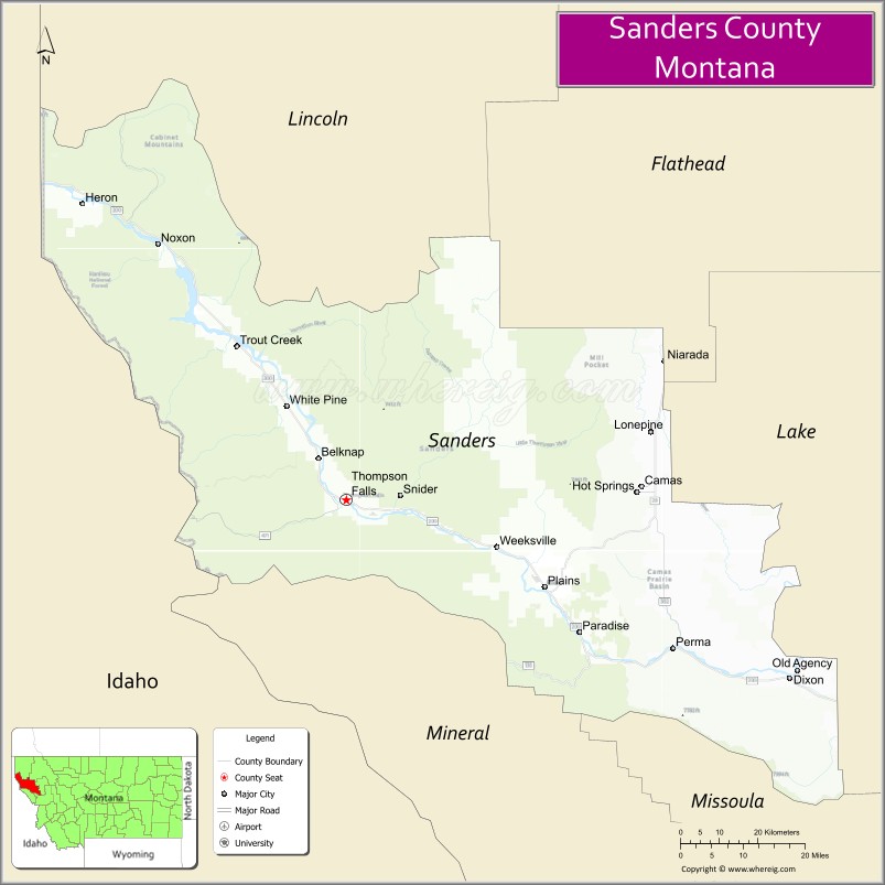
About Sanders County Map, Montana: The map showing the county boundary, county seat, major cities, highways, water bodies and neighbouring counties.
Other Montana Maps & Info
Map of Sanders County, Montana
Sanders County is a county located in the U.S. state of Montana. It's county seat is Thompson Falls. As per 2020 census, the population of Sanders County is 12959 people and population density is square miles. According to the United States Census Bureau, the county has a total area of 2,762 sq mi (7,154 km2). Sanders County was established on 1865.
Sanders County Facts
| Continent | North America |
| Country | United States |
| State | Montana |
| County Seat | Thompson Falls |
| Largest City/Town | Thompson Falls |
| Established | 1905 |
| Total Area | 2,790 sq mi (7,226 sq km) |
| Land Area | 2,761 sq mi (7,151 sq km) |
| Water Area | 29 sq mi (75 sq km) |
| Population | 12,113 (Census 2020) |
| Population Density | 4.4 people per sq mi |
| Time Zone | Mountain Time Zone (MST/MDT) |
| Major Highways | U.S. Route 2, Montana Highway 200 |
| Major Rivers | Clark Fork River |
| Neighboring Counties | Lincoln County, Flathead County, Lake County, Missoula County, Mineral County |
| Famous For | Clark Fork River recreation, mountain forests, trout fishing, and scenic wilderness |
| Top Attractions | Thompson Falls State Park nearby region, Cabinet Mountains Wilderness, Noxon Rapids Reservoir, and Flathead Indian Reservation nearby areas |
| Official Website | Official Website |
About Sanders County, Montana
Sanders County is located in northwestern Montana in the western United States and was established in 1905. The county seat and largest town is Thompson Falls. The county is known for its scenic mountain landscapes, river recreation, trout fishing, forested wilderness areas, and outdoor tourism opportunities.
Cities and Towns in Sanders County, Montana
| City/Town | Population (Census 2020) | Latitude & Longitude |
|---|---|---|
| Thompson Falls (county seat) | 1,336 | 47.5958°N, 115.3382°W |
| Plains | 1,106 | 47.4602°N, 114.8824°W |
| Hot Springs | 544 | 47.6110°N, 114.6682°W |
| Noxon | 218 | 47.9970°N, 115.7847°W |
| Paradise | 138 | 47.3840°N, 114.9187°W |
| Dixon | 221 | 47.3018°N, 114.3120°W |
Golf Courses in Sanders County, Montana
| Golf Course | Location | Latitude & Longitude |
|---|---|---|
| River's Bend Golf Course | Thompson Falls | 47.6024°N, 115.3456°W |
| Plains Valley Golf Club | Plains | 47.4667°N, 114.8898°W |
Major Roads and Highways in Sanders County, Montana
Major highways connect the county with northwestern Montana valleys and mountain recreation regions.
- U.S. Route 2 - major east-west route through northwestern Montana
- Montana Highway 200 - scenic highway following the Clark Fork River corridor
What are the Neighboring Counties of Sanders County
- Lincoln County (north)
- Flathead County (northeast)
- Lake County (east)
- Missoula County (southeast)
- Mineral County (south)
What are the top Attractions in Sanders County, Montana
The county offers a mix of mountain recreation, river scenery, and wilderness adventures.
- Thompson Falls State Park nearby region - scenic riverfront recreation and camping destination
- Cabinet Mountains Wilderness - hiking, backpacking, fishing, and wildlife viewing area
- Noxon Rapids Reservoir - boating, fishing, and lakeside recreation destination
- Flathead Indian Reservation nearby areas - cultural and historical attractions of the Salish and Kootenai Tribes
- Clark Fork River - nationally known fishing, rafting, and scenic recreation corridor
- Hot Springs Mineral Pools - natural hot springs and relaxation destination
- Thompson Falls Historic District - western-style downtown with local shops and museums
- Scotchman Peaks Wilderness nearby region - mountain hiking and scenic viewpoints
- Plains Valley Recreation Areas - camping, wildlife viewing, and river activities
- Northwestern Montana Scenic Drives - panoramic forest, mountain, and river valley routes
Distance from Sanders County to Nearby Cities
The following distances are measured by road (driving).
- Thompson Falls to Missoula (Missoula County), Montana - 100 mi (161 km)
- Thompson Falls to Kalispell (Flathead County), Montana - 122 mi (196 km)
- Thompson Falls to Spokane (Spokane County), Washington - 145 mi (233 km)
- Thompson Falls to Coeur d'Alene (Kootenai County), Idaho - 102 mi (164 km)
- Thompson Falls to Plains (Sanders County), Montana - 29 mi (47 km)
- Thompson Falls to Hot Springs (Sanders County), Montana - 47 mi (76 km)
- Thompson Falls to Helena (Lewis and Clark County), Montana - 210 mi (338 km)
- Thompson Falls to Bozeman (Gallatin County), Montana - 300 mi (483 km)
- Thompson Falls to Seattle (King County), Washington - 390 mi (628 km)
- Thompson Falls to Billings (Yellowstone County), Montana - 437 mi (703 km)
- Thompson Falls to Calgary, Alberta - 396 mi (637 km)
- Thompson Falls to Salt Lake City (Salt Lake County), Utah - 590 mi (950 km)
- Thompson Falls to Denver (Denver County), Colorado - 816 mi (1,313 km)
FAQs about Sanders County
Sanders County is located in northwestern Montana along the Clark Fork River corridor.
Sanders County had a population of 12,113 according to the 2020 United States Census.
Sanders County is known for mountain scenery, river recreation, trout fishing, and wilderness areas.
The county is served by U.S. Route 2 and Montana Highway 200.
Yes, Sanders County includes golf facilities such as River's Bend Golf Course and Plains Valley Golf Club.
References
- QuickFacts - U.S. Census Bureau
- United States Census Bureau
- United States Geological Survey (USGS)
- National Geodetic Survey
- Official Website
- Beaverhead County Map
- Big Horn County Map
- Blaine County Map
- Broadwater County Map
- Carbon County Map
- Carter County Map
- Cascade County Map
- Chouteau County Map
- Custer County Map
- Daniels County Map
- Dawson County Map
- Deer Lodge County Map
- Fallon County Map
- Fergus County Map
- Flathead County Map
- Gallatin County Map
- Garfield County Map
- Glacier County Map
- Golden Valley County Map
- Granite County Map
- Hill County Map
- Jefferson County Map
- Judith Basin County Map
- Lake County Map
- Lewis and Clark County Map
- Liberty County Map
- Lincoln County Map
- McCone County Map
- Madison County Map
- Meagher County Map
- Mineral County Map
- Missoula County Map
- Musselshell County Map
- Park County Map
- Petroleum County Map
- Phillips County Map
- Pondera County Map
- Powder River County Map
- Powell County Map
- Prairie County Map
- Ravalli County Map
- Richland County Map
- Roosevelt County Map
- Rosebud County Map
- Sanders County Map
- Sheridan County Map
- Silver Bow County Map
- Stillwater County Map
- Sweet Grass County Map
- Teton County Map
- Toole County Map
- Treasure County Map
- Valley County Map
- Wheatland County Map
- Wibaux County Map
- Yellowstone County Map
- Alabama Counties
- Alaska boroughs
- Arizona Counties
- Arkansas Counties
- California County Map
- Colorado Counties
- Connecticut Counties
- Delaware Counties
- Florida County Map
- Georgia County Map
- Hawaii Counties
- Idaho Counties
- Illinois Counties
- Indiana Counties
- Iowa Counties
- Kansas Counties
- Kentucky Counties
- Louisiana Counties
- Maine Counties
- Maryland Counties
- Massachusetts Counties
- Michigan County Map
- Minnesota Counties
- Mississippi Counties
- Missouri Counties
- Montana Counties
- Nebraska Counties
- Nevada Counties
- New York Counties
- New Hampshire Counties
- New Jersey Counties
- New Mexico Counties
- North Carolina Counties
- North Dakota Counties
- Ohio County Map
- Oklahoma Counties
- Oregon Counties
- Pennsylvania Counties
- Rhode Island Counties
- South Carolina Counties
- South Dakota Counties
- Map of Tennessee
- Texas County Map
- Utah Counties
- Vermont Counties
- Virginia Counties
- Washington Counties
- West Virginia Counties
- Wisconsin Counties
- Wyoming Counties