Map of Pondera County - Pondera County is a county located in the U.S. state of Montana. Pondera County Map showing cities, highways, important places and water bodies. Get Where is Pondera County located in the map, major cities in Pondera county, population, areas, and places of interest.
Map of Pondera County, Montana
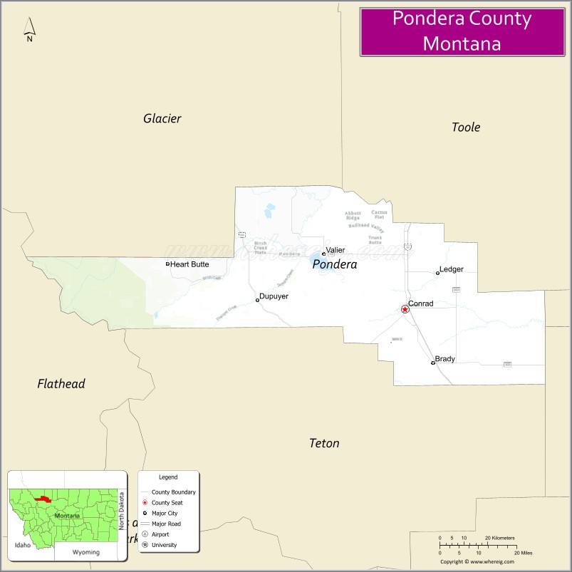
About Pondera County Map, Montana: The map showing the county boundary, county seat, major cities, highways, water bodies and neighbouring counties.
Other Montana Maps & Info
Map of Pondera County, Montana
Pondera County is a county located in the U.S. state of Montana. It's county seat is Conrad. As per 2020 census, the population of Pondera County is 5994 people and population density is square miles. According to the United States Census Bureau, the county has a total area of 1,625 sq mi (4,209 km2). Pondera County was established on 6988.
Pondera County Facts
| Continent | North America |
| Country | United States |
| State | Montana |
| County Seat | Conrad |
| Largest City/Town | Conrad |
| Established | 1919 |
| Total Area | 1,640 sq mi (4,248 sq km) |
| Land Area | 1,625 sq mi (4,209 sq km) |
| Water Area | 15 sq mi (39 sq km) |
| Population | 5,869 (Census 2020) |
| Population Density | 3.6 people per sq mi |
| Time Zone | Mountain Time Zone (MST/MDT) |
| Major Highways | Interstate 15, U.S. Route 89, Montana Highway 44 |
| Major Rivers | Marias River, Teton River |
| Neighboring Counties | Toole County, Glacier County, Teton County, Lewis and Clark County |
| Famous For | Wheat farming, Rocky Mountain Front scenery, and agricultural heritage |
| Top Attractions | Conrad Transportation and Historical Museum, Rocky Mountain Front nearby region, Freezeout Lake Wildlife Management Area, and Teton Pass scenery |
| Official Website | Official Website |
About Pondera County, Montana
Pondera County is located in north-central Montana in the western United States and was established in 1919. The county seat and largest town is Conrad. The county is known for its productive wheat farms, scenic prairie landscapes, proximity to the Rocky Mountain Front, and strong agricultural traditions.
Cities and Towns in Pondera County, Montana
| City/Town | Population (Census 2020) | Latitude & Longitude |
|---|---|---|
| Conrad (county seat) | 2,594 | 48.1705°N, 111.9466°W |
| Valier | 509 | 48.3061°N, 112.2504°W |
| Dupuyer | 86 | 48.1897°N, 112.4913°W |
| Brady | 140 | 48.0302°N, 111.7116°W |
| Ledger | 95 | 48.2604°N, 111.8727°W |
| Heart Butte (partial nearby region) | 544 | 48.2850°N, 112.8434°W |
Golf Courses in Pondera County, Montana
| Golf Course | Location | Latitude & Longitude |
|---|---|---|
| Pondera Golf Club | Conrad | 48.1768°N, 111.9539°W |
| Lake Frances Golf Recreation Area | Valier | 48.3122°N, 112.2576°W |
Major Roads and Highways in Pondera County, Montana
Major highways connect the county with northern Montana farming communities and Rocky Mountain recreation areas.
- Interstate 15 - major north-south interstate through north-central Montana
- U.S. Route 89 - scenic route linking the Rocky Mountain Front and prairie regions
- Montana Highway 44 - regional highway serving agricultural communities
What are the Neighboring Counties of Pondera County
- Toole County (north)
- Glacier County (west)
- Teton County (south)
- Lewis and Clark County (southeast)
What are the top Attractions in Pondera County, Montana
The county offers a mix of prairie landscapes, agricultural heritage, and wildlife recreation.
- Conrad Transportation and Historical Museum - exhibits on railroads, farming, and local history
- Rocky Mountain Front nearby region - dramatic mountain scenery and outdoor recreation access
- Freezeout Lake Wildlife Management Area - major birdwatching destination for snow geese and migratory birds
- Teton Pass Scenic Region - panoramic prairie and mountain landscapes
- Lake Frances Recreation Area - boating, fishing, and camping near Valier
- Pondera Prairie Scenic Drives - countryside routes through wheat fields and ranchlands
- Dupuyer Valley - scenic ranching community near the mountains
- Marias River Recreation Areas - fishing and wildlife viewing opportunities
- Valier Historic District - small-town center with local shops and western heritage
- Central Montana Agricultural Heritage Sites - attractions celebrating farming traditions
Distance from Pondera County to Nearby Cities
The following distances are measured by road (driving).
- Conrad to Great Falls (Cascade County), Montana - 63 mi (101 km)
- Conrad to Cut Bank (Glacier County), Montana - 38 mi (61 km)
- Conrad to Shelby (Toole County), Montana - 32 mi (51 km)
- Conrad to Helena (Lewis and Clark County), Montana - 151 mi (243 km)
- Conrad to Kalispell (Flathead County), Montana - 121 mi (195 km)
- Conrad to Valier (Pondera County), Montana - 13 mi (21 km)
- Conrad to Dupuyer (Pondera County), Montana - 35 mi (56 km)
- Conrad to Havre (Hill County), Montana - 109 mi (175 km)
- Conrad to Bozeman (Gallatin County), Montana - 229 mi (369 km)
- Conrad to Missoula (Missoula County), Montana - 214 mi (344 km)
- Conrad to Calgary, Alberta - 228 mi (367 km)
- Conrad to Spokane (Spokane County), Washington - 442 mi (711 km)
- Conrad to Denver (Denver County), Colorado - 778 mi (1,252 km)
FAQs about Pondera County
Pondera County is located in north-central Montana near the Rocky Mountain Front.
Pondera County had a population of 5,869 according to the 2020 United States Census.
Pondera County is known for wheat farming, prairie scenery, wildlife areas, and agricultural heritage.
The county is served by Interstate 15, U.S. Route 89, and Montana Highway 44.
Yes, Pondera County includes golf facilities such as Pondera Golf Club and recreation golf areas near Lake Frances.
References
- QuickFacts - U.S. Census Bureau
- United States Census Bureau
- United States Geological Survey (USGS)
- National Geodetic Survey
- Official Website
- Beaverhead County Map
- Big Horn County Map
- Blaine County Map
- Broadwater County Map
- Carbon County Map
- Carter County Map
- Cascade County Map
- Chouteau County Map
- Custer County Map
- Daniels County Map
- Dawson County Map
- Deer Lodge County Map
- Fallon County Map
- Fergus County Map
- Flathead County Map
- Gallatin County Map
- Garfield County Map
- Glacier County Map
- Golden Valley County Map
- Granite County Map
- Hill County Map
- Jefferson County Map
- Judith Basin County Map
- Lake County Map
- Lewis and Clark County Map
- Liberty County Map
- Lincoln County Map
- McCone County Map
- Madison County Map
- Meagher County Map
- Mineral County Map
- Missoula County Map
- Musselshell County Map
- Park County Map
- Petroleum County Map
- Phillips County Map
- Pondera County Map
- Powder River County Map
- Powell County Map
- Prairie County Map
- Ravalli County Map
- Richland County Map
- Roosevelt County Map
- Rosebud County Map
- Sanders County Map
- Sheridan County Map
- Silver Bow County Map
- Stillwater County Map
- Sweet Grass County Map
- Teton County Map
- Toole County Map
- Treasure County Map
- Valley County Map
- Wheatland County Map
- Wibaux County Map
- Yellowstone County Map
- Alabama Counties
- Alaska boroughs
- Arizona Counties
- Arkansas Counties
- California County Map
- Colorado Counties
- Connecticut Counties
- Delaware Counties
- Florida County Map
- Georgia County Map
- Hawaii Counties
- Idaho Counties
- Illinois Counties
- Indiana Counties
- Iowa Counties
- Kansas Counties
- Kentucky Counties
- Louisiana Counties
- Maine Counties
- Maryland Counties
- Massachusetts Counties
- Michigan County Map
- Minnesota Counties
- Mississippi Counties
- Missouri Counties
- Montana Counties
- Nebraska Counties
- Nevada Counties
- New York Counties
- New Hampshire Counties
- New Jersey Counties
- New Mexico Counties
- North Carolina Counties
- North Dakota Counties
- Ohio County Map
- Oklahoma Counties
- Oregon Counties
- Pennsylvania Counties
- Rhode Island Counties
- South Carolina Counties
- South Dakota Counties
- Map of Tennessee
- Texas County Map
- Utah Counties
- Vermont Counties
- Virginia Counties
- Washington Counties
- West Virginia Counties
- Wisconsin Counties
- Wyoming Counties