Map of Flathead County - Flathead County is a county located in the U.S. state of Montana. Flathead County Map showing cities, highways, important places and water bodies. Get Where is Flathead County located in the map, major cities in Flathead county, population, areas, and places of interest.
Map of Flathead County, Montana
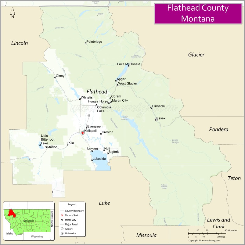
About Flathead County Map, Montana: The map showing the county boundary, county seat, major cities, highways, water bodies and neighbouring counties.
Other Montana Maps & Info
Map of Flathead County, Montana
Flathead County is a county located in the U.S. state of Montana. It's county seat is Kalispell. As per 2020 census, the population of Flathead County is 108454 people and population density is square miles. According to the United States Census Bureau, the county has a total area of 5,099 sq mi (13,206 km2). Flathead County was established on -2518.
Flathead County Facts
| Continent | North America |
| Country | United States |
| State | Montana |
| County Seat | Kalispell |
| Largest City/Town | Kalispell |
| Established | 1893 |
| Total Area | 5,256 sq mi (13,613 sq km) |
| Land Area | 4,982 sq mi (12,903 sq km) |
| Water Area | 274 sq mi (710 sq km) |
| Population | 104,357 (Census 2020) |
| Population Density | 20.9 people per sq mi |
| Time Zone | Mountain Time Zone (MST/MDT) |
| Major Highways | U.S. Route 2, U.S. Route 93, Montana Highway 35 |
| Major Rivers | Flathead River, Swan River |
| Neighboring Counties | Lincoln County, Sanders County, Lake County, Glacier County, Powell County |
| Famous For | Glacier National Park, Flathead Lake, Whitefish Mountain Resort, and Rocky Mountain scenery |
| Top Attractions | Glacier National Park, Flathead Lake, Whitefish Mountain Resort, and Conrad Mansion Museum |
| Official Website | Official Website |
About Flathead County, Montana
Flathead County is located in northwestern Montana in the western United States and was established in 1893. The county seat and largest city is Kalispell. The county is known for its stunning mountain scenery, outdoor recreation, glacier-carved lakes, ski resorts, and as a gateway to Glacier National Park.
Cities and Towns in Flathead County, Montana
| City/Town | Population (Census 2020) | Latitude & Longitude |
|---|---|---|
| Kalispell (county seat) | 24,558 | 48.1958°N, 114.3129°W |
| Whitefish | 7,751 | 48.4111°N, 114.3376°W |
| Columbia Falls | 5,655 | 48.3725°N, 114.1815°W |
| Bigfork | 1,421 | 48.0622°N, 114.0726°W |
| Evergreen (CDP) | 7,624 | 48.2050°N, 114.2685°W |
| Marion (CDP) | 1,026 | 48.1024°N, 114.7342°W |
Golf Courses in Flathead County, Montana
| Golf Course | Location | Latitude & Longitude |
|---|---|---|
| Whitefish Lake Golf Club | Whitefish | 48.4178°N, 114.3439°W |
| Buffalo Hill Golf Club | Kalispell | 48.2056°N, 114.3011°W |
Major Roads and Highways in Flathead County, Montana
Major highways connect the county with Glacier National Park and northwestern Montana communities.
- U.S. Route 2 - scenic east-west highway linking Kalispell with Glacier National Park and Idaho
- U.S. Route 93 - major north-south route through the Flathead Valley
- Montana Highway 35 - scenic lakeside highway along Flathead Lake
What are the Neighboring Counties of Flathead County
- Lincoln County (northwest)
- Glacier County (east)
- Powell County (southeast)
- Lake County (south)
- Sanders County (southwest)
What are the top Attractions in Flathead County, Montana
The county offers a mix of mountain recreation, scenic lakes, and cultural attractions.
- Glacier National Park - world-famous national park with alpine scenery, hiking trails, and wildlife viewing
- Flathead Lake - one of the largest freshwater lakes in the western United States
- Whitefish Mountain Resort - major ski resort with year-round outdoor recreation
- Conrad Mansion Museum - historic mansion museum in Kalispell showcasing regional history
- Going-to-the-Sun Road - scenic mountain highway crossing Glacier National Park
- Bigfork Village - arts and cultural destination along Flathead Lake
- Flathead National Forest - vast forest recreation area with camping, hiking, and fishing
- Whitefish Lake State Park - lakeside recreation area with boating and camping
- Lone Pine State Park - scenic overlook park with trails and panoramic valley views
- Hungry Horse Dam - large concrete dam and reservoir near Glacier National Park
Distance from Flathead County to Nearby Cities
The following distances are measured by road (driving).
- Kalispell to Whitefish (Flathead County), Montana - 15 mi (24 km)
- Kalispell to Columbia Falls (Flathead County), Montana - 17 mi (27 km)
- Kalispell to Glacier National Park (West Entrance) - 33 mi (53 km)
- Kalispell to Missoula (Missoula County), Montana - 120 mi (193 km)
- Kalispell to Great Falls (Cascade County), Montana - 214 mi (344 km)
- Kalispell to Spokane (Spokane County), Washington - 274 mi (441 km)
- Kalispell to Helena (Lewis and Clark County), Montana - 217 mi (349 km)
- Kalispell to Bozeman (Gallatin County), Montana - 308 mi (496 km)
- Kalispell to Bigfork (Flathead County), Montana - 18 mi (29 km)
- Kalispell to Sandpoint (Bonner County), Idaho - 103 mi (166 km)
- Kalispell to Calgary, Alberta - 288 mi (463 km)
- Kalispell to Seattle (King County), Washington - 506 mi (814 km)
- Kalispell to Salt Lake City (Salt Lake County), Utah - 706 mi (1,136 km)
FAQs about Flathead County
Flathead County is located in northwestern Montana near Glacier National Park.
Flathead County had a population of 104,357 according to the 2020 United States Census.
Flathead County is known for Glacier National Park, Flathead Lake, mountain scenery, and outdoor recreation.
The county is served by U.S. Route 2, U.S. Route 93, and Montana Highway 35.
Yes, Flathead County includes golf facilities such as Whitefish Lake Golf Club and Buffalo Hill Golf Club.
References
- QuickFacts - U.S. Census Bureau
- United States Census Bureau
- United States Geological Survey (USGS)
- National Geodetic Survey
- Official Website
- Beaverhead County Map
- Big Horn County Map
- Blaine County Map
- Broadwater County Map
- Carbon County Map
- Carter County Map
- Cascade County Map
- Chouteau County Map
- Custer County Map
- Daniels County Map
- Dawson County Map
- Deer Lodge County Map
- Fallon County Map
- Fergus County Map
- Flathead County Map
- Gallatin County Map
- Garfield County Map
- Glacier County Map
- Golden Valley County Map
- Granite County Map
- Hill County Map
- Jefferson County Map
- Judith Basin County Map
- Lake County Map
- Lewis and Clark County Map
- Liberty County Map
- Lincoln County Map
- McCone County Map
- Madison County Map
- Meagher County Map
- Mineral County Map
- Missoula County Map
- Musselshell County Map
- Park County Map
- Petroleum County Map
- Phillips County Map
- Pondera County Map
- Powder River County Map
- Powell County Map
- Prairie County Map
- Ravalli County Map
- Richland County Map
- Roosevelt County Map
- Rosebud County Map
- Sanders County Map
- Sheridan County Map
- Silver Bow County Map
- Stillwater County Map
- Sweet Grass County Map
- Teton County Map
- Toole County Map
- Treasure County Map
- Valley County Map
- Wheatland County Map
- Wibaux County Map
- Yellowstone County Map
- Alabama Counties
- Alaska boroughs
- Arizona Counties
- Arkansas Counties
- California County Map
- Colorado Counties
- Connecticut Counties
- Delaware Counties
- Florida County Map
- Georgia County Map
- Hawaii Counties
- Idaho Counties
- Illinois Counties
- Indiana Counties
- Iowa Counties
- Kansas Counties
- Kentucky Counties
- Louisiana Counties
- Maine Counties
- Maryland Counties
- Massachusetts Counties
- Michigan County Map
- Minnesota Counties
- Mississippi Counties
- Missouri Counties
- Montana Counties
- Nebraska Counties
- Nevada Counties
- New York Counties
- New Hampshire Counties
- New Jersey Counties
- New Mexico Counties
- North Carolina Counties
- North Dakota Counties
- Ohio County Map
- Oklahoma Counties
- Oregon Counties
- Pennsylvania Counties
- Rhode Island Counties
- South Carolina Counties
- South Dakota Counties
- Map of Tennessee
- Texas County Map
- Utah Counties
- Vermont Counties
- Virginia Counties
- Washington Counties
- West Virginia Counties
- Wisconsin Counties
- Wyoming Counties