Map of Lake County - Lake County is a county located in the U.S. state of Montana. Lake County Map showing cities, highways, important places and water bodies. Get Where is Lake County located in the map, major cities in Lake county, population, areas, and places of interest.
Map of Lake County, Montana
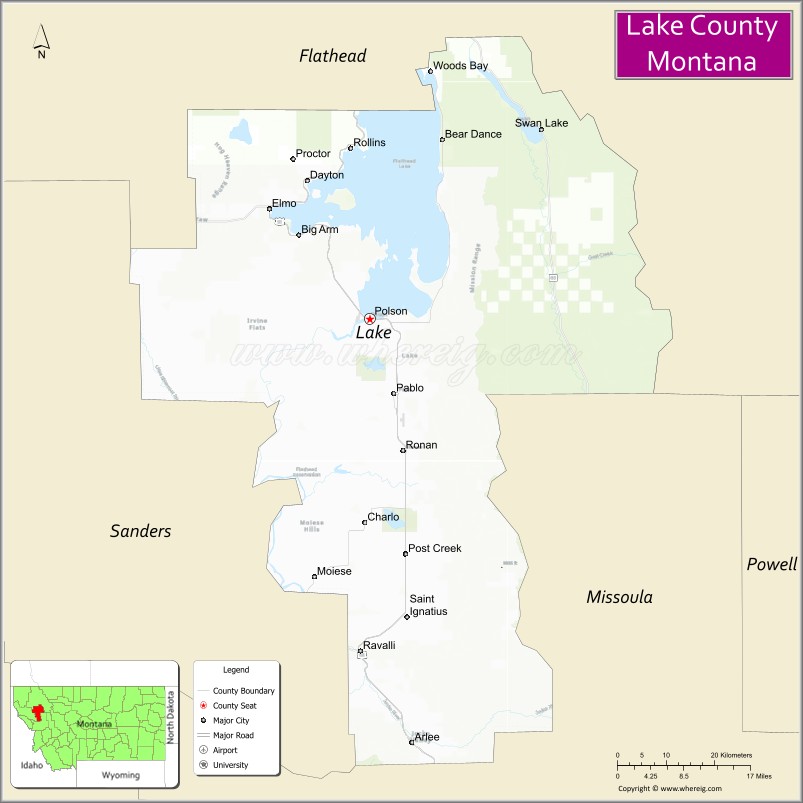
About Lake County Map, Montana: The map showing the county boundary, county seat, major cities, highways, water bodies and neighbouring counties.
Other Montana Maps & Info
Map of Lake County, Montana
Mineral County is a county located in the U.S. state of Montana. It`s county seat is Superior. As per 2020 census, the population of Mineral County was 4860 and population density of Mineral was square miles. According to the United States Census Bureau, the county has a total area of 1,220 sq mi (3,160 km2). Mineral County was established on 5333.
Lake County Facts
| Continent | North America |
| Country | United States |
| State | Montana |
| County Seat | Polson |
| Largest City/Town | Polson |
| Established | 1923 |
| Total Area | 1,654 sq mi (4,283 sq km) |
| Land Area | 1,490 sq mi (3,859 sq km) |
| Water Area | 164 sq mi (425 sq km) |
| Population | 31,364 (Census 2020) |
| Population Density | 21.0 people per sq mi |
| Time Zone | Mountain Time Zone (MST/MDT) |
| Major Highways | U.S. Route 93, Montana Highway 35, Montana Highway 200 |
| Major Rivers | Flathead River, Jocko River |
| Neighboring Counties | Flathead County, Sanders County, Missoula County, Powell County, Lewis and Clark County |
| Famous For | Flathead Lake, Confederated Salish and Kootenai Tribes, and scenic mountain recreation |
| Top Attractions | Flathead Lake, Wild Horse Island State Park, National Bison Range nearby region, and Miracle of America Museum |
| Official Website | Official Website |
About Lake County, Montana
Lake County is located in northwestern Montana in the western United States and was established in 1923. The county seat and largest city is Polson. The county is known for Flathead Lake, Native American cultural heritage, scenic mountain landscapes, and outdoor recreation opportunities throughout the Flathead Valley region.
Cities and Towns in Lake County, Montana
| City/Town | Population (Census 2020) | Latitude & Longitude |
|---|---|---|
| Polson (county seat) | 5,148 | 47.6936°N, 114.1632°W |
| Ronan | 2,126 | 47.5286°N, 114.1037°W |
| St. Ignatius | 842 | 47.3197°N, 114.0943°W |
| Pablo (CDP) | 2,351 | 47.6069°N, 114.1029°W |
| Charlo | 385 | 47.4402°N, 114.1679°W |
| Big Arm (CDP) | 194 | 47.7791°N, 114.2824°W |
Golf Courses in Lake County, Montana
| Golf Course | Location | Latitude & Longitude |
|---|---|---|
| Polson Bay Golf Course | Polson | 47.6959°N, 114.1708°W |
| Mission Mountain Golf Course | Ronan | 47.5318°N, 114.1116°W |
Major Roads and Highways in Lake County, Montana
Major highways connect the county with Flathead Lake communities and northwestern Montana recreation destinations.
- U.S. Route 93 - major north-south highway along Flathead Lake and Mission Valley
- Montana Highway 35 - scenic route along the eastern shore of Flathead Lake
- Montana Highway 200 - regional route connecting western Montana valleys and recreation areas
What are the Neighboring Counties of Lake County
- Flathead County (north)
- Sanders County (west)
- Missoula County (south)
- Powell County (southeast)
- Lewis and Clark County (east)
What are the top Attractions in Lake County, Montana
The county offers a mix of lake recreation, tribal culture, and scenic mountain landscapes.
- Flathead Lake - one of the largest freshwater lakes in the western United States with boating and fishing opportunities
- Wild Horse Island State Park - island park known for wildlife viewing, hiking, and scenic lake access
- National Bison Range nearby region - wildlife refuge featuring bison, elk, and mountain scenery
- Miracle of America Museum - museum with transportation, military, and local history exhibits
- Mission Mountains - dramatic mountain range offering hiking and wilderness recreation
- Confederated Salish and Kootenai Tribes Cultural Areas - heritage attractions and tribal history sites
- St. Ignatius Mission - historic Catholic mission church with murals and architecture
- Flathead Lake State Park - lakeside recreation with camping, boating, and beaches
- Polson Downtown Waterfront - shopping, dining, and scenic views along Flathead Lake
- Ninepipe National Wildlife Refuge nearby region - birdwatching and wetland recreation destination
Distance from Lake County to Nearby Cities
The following distances are measured by road (driving).
- Polson to Kalispell (Flathead County), Montana - 69 mi (111 km)
- Polson to Missoula (Missoula County), Montana - 71 mi (114 km)
- Polson to Ronan (Lake County), Montana - 11 mi (18 km)
- Polson to St. Ignatius (Lake County), Montana - 24 mi (39 km)
- Polson to Helena (Lewis and Clark County), Montana - 166 mi (267 km)
- Polson to Great Falls (Cascade County), Montana - 210 mi (338 km)
- Polson to Bozeman (Gallatin County), Montana - 261 mi (420 km)
- Polson to Spokane (Spokane County), Washington - 208 mi (335 km)
- Polson to Coeur d'Alene (Kootenai County), Idaho - 161 mi (259 km)
- Polson to Seattle (King County), Washington - 493 mi (793 km)
- Polson to Calgary, Alberta - 336 mi (541 km)
- Polson to Salt Lake City (Salt Lake County), Utah - 625 mi (1,006 km)
- Polson to Denver (Denver County), Colorado - 839 mi (1,350 km)
FAQs about Lake County
Lake County is located in northwestern Montana surrounding the southern portion of Flathead Lake.
Lake County had a population of 31,364 according to the 2020 United States Census.
Lake County is known for Flathead Lake, tribal heritage, mountain scenery, and outdoor recreation.
The county is served by U.S. Route 93, Montana Highway 35, and Montana Highway 200.
Yes, Lake County includes golf facilities such as Polson Bay Golf Course and Mission Mountain Golf Course.
References
- QuickFacts - U.S. Census Bureau
- United States Census Bureau
- United States Geological Survey (USGS)
- National Geodetic Survey
- Official Website
- Beaverhead County Map
- Big Horn County Map
- Blaine County Map
- Broadwater County Map
- Carbon County Map
- Carter County Map
- Cascade County Map
- Chouteau County Map
- Custer County Map
- Daniels County Map
- Dawson County Map
- Deer Lodge County Map
- Fallon County Map
- Fergus County Map
- Flathead County Map
- Gallatin County Map
- Garfield County Map
- Glacier County Map
- Golden Valley County Map
- Granite County Map
- Hill County Map
- Jefferson County Map
- Judith Basin County Map
- Lake County Map
- Lewis and Clark County Map
- Liberty County Map
- Lincoln County Map
- McCone County Map
- Madison County Map
- Meagher County Map
- Mineral County Map
- Missoula County Map
- Musselshell County Map
- Park County Map
- Petroleum County Map
- Phillips County Map
- Pondera County Map
- Powder River County Map
- Powell County Map
- Prairie County Map
- Ravalli County Map
- Richland County Map
- Roosevelt County Map
- Rosebud County Map
- Sanders County Map
- Sheridan County Map
- Silver Bow County Map
- Stillwater County Map
- Sweet Grass County Map
- Teton County Map
- Toole County Map
- Treasure County Map
- Valley County Map
- Wheatland County Map
- Wibaux County Map
- Yellowstone County Map
- Alabama Counties
- Alaska boroughs
- Arizona Counties
- Arkansas Counties
- California County Map
- Colorado Counties
- Connecticut Counties
- Delaware Counties
- Florida County Map
- Georgia County Map
- Hawaii Counties
- Idaho Counties
- Illinois Counties
- Indiana Counties
- Iowa Counties
- Kansas Counties
- Kentucky Counties
- Louisiana Counties
- Maine Counties
- Maryland Counties
- Massachusetts Counties
- Michigan County Map
- Minnesota Counties
- Mississippi Counties
- Missouri Counties
- Montana Counties
- Nebraska Counties
- Nevada Counties
- New York Counties
- New Hampshire Counties
- New Jersey Counties
- New Mexico Counties
- North Carolina Counties
- North Dakota Counties
- Ohio County Map
- Oklahoma Counties
- Oregon Counties
- Pennsylvania Counties
- Rhode Island Counties
- South Carolina Counties
- South Dakota Counties
- Map of Tennessee
- Texas County Map
- Utah Counties
- Vermont Counties
- Virginia Counties
- Washington Counties
- West Virginia Counties
- Wisconsin Counties
- Wyoming Counties