Map of Phillips County - Phillips County is a county located in the U.S. state of Montana. Phillips County Map showing cities, highways, important places and water bodies. Get Where is Phillips County located in the map, major cities in Phillips county, population, areas, and places of interest.
Map of Phillips County, Montana
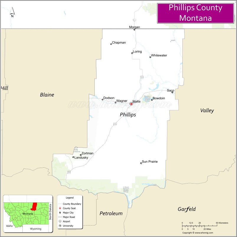
About Phillips County Map, Montana: The map showing the county boundary, county seat, major cities, highways, water bodies and neighbouring counties.
Other Montana Maps & Info
Map of Phillips County, Montana
Phillips County is a county located in the U.S. state of Montana. It's county seat is Malta. As per 2020 census, the population of Phillips County is 4192 people and population density is square miles. According to the United States Census Bureau, the county has a total area of 5,140 sq mi (13,313 km2). Phillips County was established on 5515.
Phillips County Facts
| Continent | North America |
| Country | United States |
| State | Montana |
| County Seat | Malta |
| Largest City/Town | Malta |
| Established | 1915 |
| Total Area | 5,140 sq mi (13,313 sq km) |
| Land Area | 5,086 sq mi (13,173 sq km) |
| Water Area | 54 sq mi (140 sq km) |
| Population | 4,253 (Census 2020) |
| Population Density | 0.8 people per sq mi |
| Time Zone | Mountain Time Zone (MST/MDT) |
| Major Highways | U.S. Route 2, Montana Highway 191, Montana Highway 66 |
| Major Rivers | Milk River, Missouri River |
| Neighboring Counties | Blaine County, Valley County, Fergus County, Petroleum County |
| Famous For | Charles M. Russell National Wildlife Refuge, ranching, and prairie landscapes |
| Top Attractions | Charles M. Russell National Wildlife Refuge, Malta Dinosaur Museum, Milk River Valley, and Bowdoin National Wildlife Refuge nearby region |
| Official Website | Official Website |
About Phillips County, Montana
Phillips County is located in north-central Montana in the western United States and was established in 1915. The county seat and largest town is Malta. The county is known for its vast prairie landscapes, wildlife refuges, ranching heritage, dinosaur discoveries, and outdoor recreation opportunities.
Cities and Towns in Phillips County, Montana
| City/Town | Population (Census 2020) | Latitude & Longitude |
|---|---|---|
| Malta (county seat) | 1,972 | 48.3597°N, 107.8740°W |
| Dodson | 110 | 48.3935°N, 108.2451°W |
| Saco | 197 | 48.4570°N, 107.3448°W |
| Zortman (CDP) | 69 | 47.9160°N, 108.5361°W |
| Whitewater | 64 | 48.7613°N, 107.5188°W |
| Loring (Rural Community) | 39 | 48.6731°N, 108.1194°W |
Golf Courses in Phillips County, Montana
| Golf Course | Location | Latitude & Longitude |
|---|---|---|
| Malta Country Club | Malta | 48.3651°N, 107.8805°W |
| Prairie View Golf Recreation Area | Saco | 48.4612°N, 107.3510°W |
Major Roads and Highways in Phillips County, Montana
Major highways connect the county with northern Montana prairie communities and wildlife recreation areas.
- U.S. Route 2 - major east-west highway across northern Montana
- Montana Highway 191 - regional route serving ranchlands and wildlife areas
- Montana Highway 66 - scenic highway leading toward the Little Rocky Mountains
What are the Neighboring Counties of Phillips County
- Valley County (east)
- Blaine County (west)
- Fergus County (southwest)
- Petroleum County (south)
What are the top Attractions in Phillips County, Montana
The county offers a mix of wildlife recreation, prairie scenery, and western heritage attractions.
- Charles M. Russell National Wildlife Refuge - expansive refuge with wildlife viewing, hunting, and scenic landscapes
- Malta Dinosaur Museum - museum featuring dinosaur fossils and paleontology exhibits
- Milk River Valley - scenic prairie river corridor with ranching landscapes
- Bowdoin National Wildlife Refuge nearby region - birdwatching and wetland wildlife destination
- Little Rocky Mountains nearby region - hiking and scenic recreation area
- Great Plains Dinosaur Trail - regional paleontology attraction route through Montana
- Malta Historic Downtown - western-style district with local shops and museums
- Zortman Mining History Area - historic mining community near the mountains
- Prairie Scenic Drives - countryside routes through open plains and ranchlands
- Missouri River Breaks nearby region - rugged canyon scenery and outdoor recreation
Distance from Phillips County to Nearby Cities
The following distances are measured by road (driving).
- Malta to Havre (Hill County), Montana - 90 mi (145 km)
- Malta to Glasgow (Valley County), Montana - 92 mi (148 km)
- Malta to Lewistown (Fergus County), Montana - 135 mi (217 km)
- Malta to Great Falls (Cascade County), Montana - 202 mi (325 km)
- Malta to Billings (Yellowstone County), Montana - 286 mi (460 km)
- Malta to Saco (Phillips County), Montana - 33 mi (53 km)
- Malta to Dodson (Phillips County), Montana - 23 mi (37 km)
- Malta to Helena (Lewis and Clark County), Montana - 274 mi (441 km)
- Malta to Bozeman (Gallatin County), Montana - 334 mi (537 km)
- Malta to Bismarck (Burleigh County), North Dakota - 347 mi (558 km)
- Malta to Calgary, Alberta - 356 mi (573 km)
- Malta to Rapid City (Pennington County), South Dakota - 470 mi (756 km)
- Malta to Denver (Denver County), Colorado - 746 mi (1,201 km)
FAQs about Phillips County
Phillips County is located in north-central Montana in the prairie and wildlife refuge region.
Phillips County had a population of 4,253 according to the 2020 United States Census.
Phillips County is known for wildlife refuges, ranching, dinosaur discoveries, and prairie scenery.
The county is served by U.S. Route 2, Montana Highway 191, and Montana Highway 66.
Yes, Phillips County includes golf facilities such as Malta Country Club and prairie recreation golf areas.
References
- QuickFacts - U.S. Census Bureau
- United States Census Bureau
- United States Geological Survey (USGS)
- National Geodetic Survey
- Official Website
- Beaverhead County Map
- Big Horn County Map
- Blaine County Map
- Broadwater County Map
- Carbon County Map
- Carter County Map
- Cascade County Map
- Chouteau County Map
- Custer County Map
- Daniels County Map
- Dawson County Map
- Deer Lodge County Map
- Fallon County Map
- Fergus County Map
- Flathead County Map
- Gallatin County Map
- Garfield County Map
- Glacier County Map
- Golden Valley County Map
- Granite County Map
- Hill County Map
- Jefferson County Map
- Judith Basin County Map
- Lake County Map
- Lewis and Clark County Map
- Liberty County Map
- Lincoln County Map
- McCone County Map
- Madison County Map
- Meagher County Map
- Mineral County Map
- Missoula County Map
- Musselshell County Map
- Park County Map
- Petroleum County Map
- Phillips County Map
- Pondera County Map
- Powder River County Map
- Powell County Map
- Prairie County Map
- Ravalli County Map
- Richland County Map
- Roosevelt County Map
- Rosebud County Map
- Sanders County Map
- Sheridan County Map
- Silver Bow County Map
- Stillwater County Map
- Sweet Grass County Map
- Teton County Map
- Toole County Map
- Treasure County Map
- Valley County Map
- Wheatland County Map
- Wibaux County Map
- Yellowstone County Map
- Alabama Counties
- Alaska boroughs
- Arizona Counties
- Arkansas Counties
- California County Map
- Colorado Counties
- Connecticut Counties
- Delaware Counties
- Florida County Map
- Georgia County Map
- Hawaii Counties
- Idaho Counties
- Illinois Counties
- Indiana Counties
- Iowa Counties
- Kansas Counties
- Kentucky Counties
- Louisiana Counties
- Maine Counties
- Maryland Counties
- Massachusetts Counties
- Michigan County Map
- Minnesota Counties
- Mississippi Counties
- Missouri Counties
- Montana Counties
- Nebraska Counties
- Nevada Counties
- New York Counties
- New Hampshire Counties
- New Jersey Counties
- New Mexico Counties
- North Carolina Counties
- North Dakota Counties
- Ohio County Map
- Oklahoma Counties
- Oregon Counties
- Pennsylvania Counties
- Rhode Island Counties
- South Carolina Counties
- South Dakota Counties
- Map of Tennessee
- Texas County Map
- Utah Counties
- Vermont Counties
- Virginia Counties
- Washington Counties
- West Virginia Counties
- Wisconsin Counties
- Wyoming Counties