Map of Sheridan County - Sheridan County is a county located in the U.S. state of Montana. Sheridan County Map showing cities, highways, important places and water bodies. Get Where is Sheridan County located in the map, major cities in Sheridan county, population, areas, and places of interest.
Map of Sheridan County, Montana
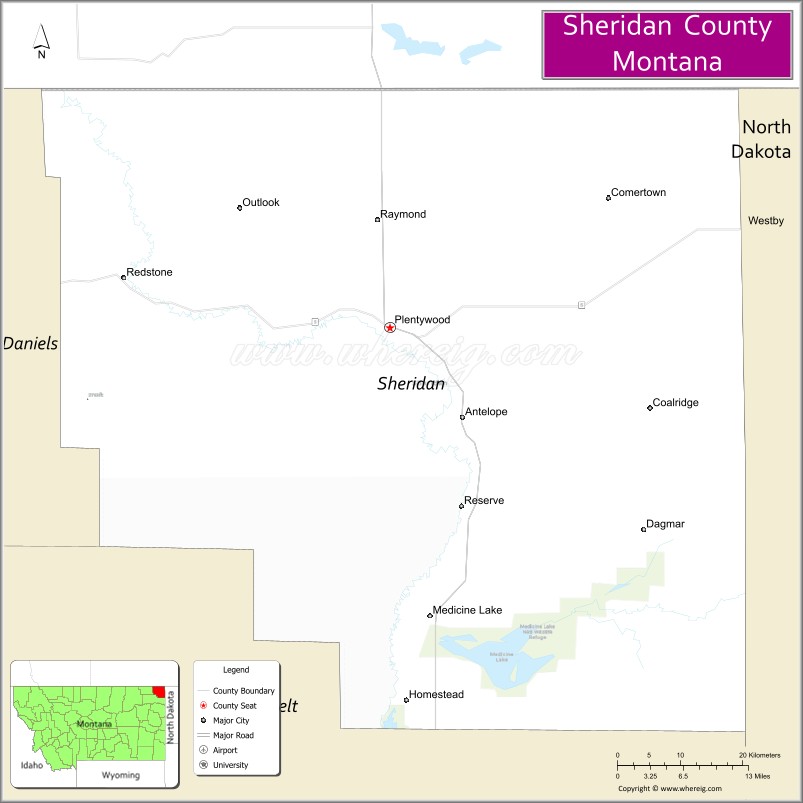
About Sheridan County Map, Montana: The map showing the county boundary, county seat, major cities, highways, water bodies and neighbouring counties.
Other Montana Maps & Info
Map of Sheridan County, Montana
Sheridan County is a county located in the U.S. state of Montana. It's county seat is Plentywood. As per 2020 census, the population of Sheridan County is 3527 people and population density is square miles. According to the United States Census Bureau, the county has a total area of 1,677 sq mi (4,343 km2). Sheridan County was established on 4832.
Sheridan County Facts
| Continent | North America |
| Country | United States |
| State | Montana |
| County Seat | Plentywood |
| Largest City/Town | Plentywood |
| Established | 1913 |
| Total Area | 1,677 sq mi (4,343 sq km) |
| Land Area | 1,670 sq mi (4,325 sq km) |
| Water Area | 7 sq mi (18 sq km) |
| Population | 3,276 (Census 2020) |
| Population Density | 2.0 people per sq mi |
| Time Zone | Mountain Time Zone (MST/MDT) |
| Major Highways | Montana Highway 16, Montana Highway 5 |
| Major Rivers | Big Muddy Creek, Missouri River nearby region |
| Neighboring Counties | Daniels County, Roosevelt County, Richland County |
| Famous For | Prairie agriculture, oil production, Canadian border location, and small-town heritage |
| Top Attractions | Plentywood Museum, Medicine Lake National Wildlife Refuge nearby region, Big Muddy Creek Valley, and prairie scenic drives |
| Official Website | Official Website |
About Sheridan County, Montana
Sheridan County is located in northeastern Montana in the western United States and was established in 1913. The county seat and largest city is Plentywood. The county is known for its agricultural economy, prairie landscapes, energy production, and communities located near the Canadian border.
Cities and Towns in Sheridan County, Montana
| City/Town | Population (Census 2020) | Latitude & Longitude |
|---|---|---|
| Plentywood (county seat) | 1,734 | 48.7761°N, 104.5619°W |
| Medicine Lake | 225 | 48.5003°N, 104.4775°W |
| Westby | 168 | 48.8570°N, 104.0427°W |
| Outlook | 84 | 48.8864°N, 104.7814°W |
| Antelope | 91 | 48.7066°N, 104.3888°W |
| Reserve | 26 | 48.5077°N, 104.4662°W |
Golf Courses in Sheridan County, Montana
| Golf Course | Location | Latitude & Longitude |
|---|---|---|
| Plentywood Golf Club | Plentywood | 48.7823°N, 104.5687°W |
| Medicine Lake Prairie Golf Area | Medicine Lake | 48.5061°N, 104.4840°W |
Major Roads and Highways in Sheridan County, Montana
Major highways connect the county with northeastern Montana farming communities and Canadian border crossings.
- Montana Highway 16 - major north-south route through eastern Montana
- Montana Highway 5 - regional highway linking prairie communities and border areas
What are the Neighboring Counties of Sheridan County
- Daniels County (west)
- Roosevelt County (southwest)
- Richland County (south)
What are the top Attractions in Sheridan County, Montana
The county offers a mix of prairie scenery, wildlife recreation, and agricultural heritage.
- Plentywood Museum - exhibits on pioneer settlement, farming, and local history
- Medicine Lake National Wildlife Refuge nearby region - birdwatching and wetland wildlife destination
- Big Muddy Creek Valley - scenic prairie and agricultural landscapes
- Prairie Scenic Drives - countryside routes through open plains and farmland
- Westby Border Region - historic northern Montana community near Canada
- Medicine Lake Recreation Areas - fishing, boating, and outdoor activities
- Sheridan County Fairgrounds - local rodeos, agricultural fairs, and community events
- Historic Plentywood Downtown - western-style architecture and small-town businesses
- Wildlife Observation Areas - habitats for deer, upland birds, and migratory waterfowl
- Northeastern Montana Open Range Landscapes - remote prairie scenery and ranching culture
Distance from Sheridan County to Nearby Cities
The following distances are measured by road (driving).
- Plentywood to Sidney (Richland County), Montana - 76 mi (122 km)
- Plentywood to Williston (Williams County), North Dakota - 79 mi (127 km)
- Plentywood to Glasgow (Valley County), Montana - 143 mi (230 km)
- Plentywood to Minot (Ward County), North Dakota - 164 mi (264 km)
- Plentywood to Bismarck (Burleigh County), North Dakota - 255 mi (410 km)
- Plentywood to Medicine Lake (Sheridan County), Montana - 20 mi (32 km)
- Plentywood to Westby (Sheridan County), Montana - 31 mi (50 km)
- Plentywood to Billings (Yellowstone County), Montana - 360 mi (579 km)
- Plentywood to Great Falls (Cascade County), Montana - 388 mi (624 km)
- Plentywood to Bozeman (Gallatin County), Montana - 491 mi (790 km)
- Plentywood to Rapid City (Pennington County), South Dakota - 438 mi (705 km)
- Plentywood to Denver (Denver County), Colorado - 708 mi (1,139 km)
- Plentywood to Minneapolis (Hennepin County), Minnesota - 698 mi (1,123 km)
FAQs about Sheridan County
Sheridan County is located in northeastern Montana near the Canadian border.
Sheridan County had a population of 3,276 according to the 2020 United States Census.
Sheridan County is known for agriculture, prairie landscapes, oil production, and border-region communities.
The county is served by Montana Highway 16 and Montana Highway 5.
Yes, Sheridan County includes golf facilities such as Plentywood Golf Club and prairie golf recreation areas near Medicine Lake.
References
- QuickFacts - U.S. Census Bureau
- United States Census Bureau
- United States Geological Survey (USGS)
- National Geodetic Survey
- Official Website
- Beaverhead County Map
- Big Horn County Map
- Blaine County Map
- Broadwater County Map
- Carbon County Map
- Carter County Map
- Cascade County Map
- Chouteau County Map
- Custer County Map
- Daniels County Map
- Dawson County Map
- Deer Lodge County Map
- Fallon County Map
- Fergus County Map
- Flathead County Map
- Gallatin County Map
- Garfield County Map
- Glacier County Map
- Golden Valley County Map
- Granite County Map
- Hill County Map
- Jefferson County Map
- Judith Basin County Map
- Lake County Map
- Lewis and Clark County Map
- Liberty County Map
- Lincoln County Map
- McCone County Map
- Madison County Map
- Meagher County Map
- Mineral County Map
- Missoula County Map
- Musselshell County Map
- Park County Map
- Petroleum County Map
- Phillips County Map
- Pondera County Map
- Powder River County Map
- Powell County Map
- Prairie County Map
- Ravalli County Map
- Richland County Map
- Roosevelt County Map
- Rosebud County Map
- Sanders County Map
- Sheridan County Map
- Silver Bow County Map
- Stillwater County Map
- Sweet Grass County Map
- Teton County Map
- Toole County Map
- Treasure County Map
- Valley County Map
- Wheatland County Map
- Wibaux County Map
- Yellowstone County Map
- Alabama Counties
- Alaska boroughs
- Arizona Counties
- Arkansas Counties
- California County Map
- Colorado Counties
- Connecticut Counties
- Delaware Counties
- Florida County Map
- Georgia County Map
- Hawaii Counties
- Idaho Counties
- Illinois Counties
- Indiana Counties
- Iowa Counties
- Kansas Counties
- Kentucky Counties
- Louisiana Counties
- Maine Counties
- Maryland Counties
- Massachusetts Counties
- Michigan County Map
- Minnesota Counties
- Mississippi Counties
- Missouri Counties
- Montana Counties
- Nebraska Counties
- Nevada Counties
- New York Counties
- New Hampshire Counties
- New Jersey Counties
- New Mexico Counties
- North Carolina Counties
- North Dakota Counties
- Ohio County Map
- Oklahoma Counties
- Oregon Counties
- Pennsylvania Counties
- Rhode Island Counties
- South Carolina Counties
- South Dakota Counties
- Map of Tennessee
- Texas County Map
- Utah Counties
- Vermont Counties
- Virginia Counties
- Washington Counties
- West Virginia Counties
- Wisconsin Counties
- Wyoming Counties