Map of Roosevelt County - Roosevelt County is a county located in the U.S. state of Montana. Roosevelt County Map showing cities, highways, important places and water bodies. Get Where is Roosevelt County located in the map, major cities in Roosevelt county, population, areas, and places of interest.
Map of Roosevelt County, Montana
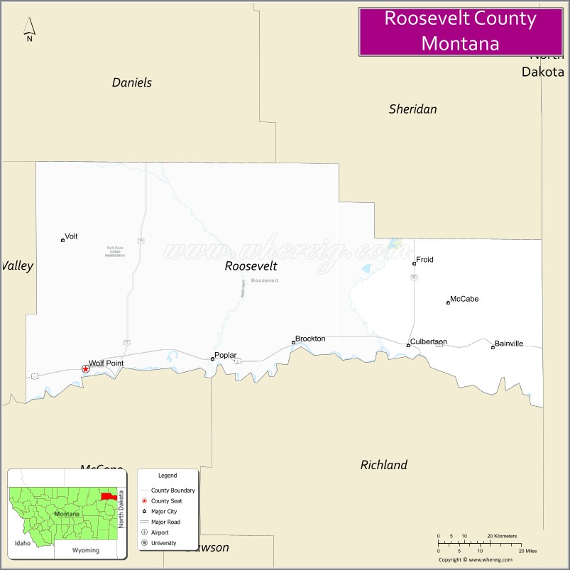
About Roosevelt County Map, Montana: The map showing the county boundary, county seat, major cities, highways, water bodies and neighbouring counties.
Other Montana Maps & Info
Map of Roosevelt County, Montana
Roosevelt County is a county located in the U.S. state of Montana. It's county seat is Wolf Point. As per 2020 census, the population of Roosevelt County is 10821 people and population density is square miles. According to the United States Census Bureau, the county has a total area of 2,356 sq mi (6,102 km2). Roosevelt County was established on 6989.
Roosevelt County Facts
| Continent | North America |
| Country | United States |
| State | Montana |
| County Seat | Wolf Point |
| Largest City/Town | Wolf Point |
| Established | 1919 |
| Total Area | 2,369 sq mi (6,136 sq km) |
| Land Area | 2,355 sq mi (6,099 sq km) |
| Water Area | 14 sq mi (37 sq km) |
| Population | 11,004 (Census 2020) |
| Population Density | 4.7 people per sq mi |
| Time Zone | Mountain Time Zone (MST/MDT) |
| Major Highways | U.S. Route 2, Montana Highway 13 |
| Major Rivers | Missouri River, Poplar River |
| Neighboring Counties | Valley County, Richland County, Sheridan County, Daniels County, McCone County |
| Famous For | Fort Peck Indian Reservation, Native American culture, agriculture, and Missouri River landscapes |
| Top Attractions | Fort Peck Indian Reservation, Wolf Point Wild Horse Stampede, Missouri River recreation, and Poplar Museum |
| Official Website | Official Website |
About Roosevelt County, Montana
Roosevelt County is located in northeastern Montana in the western United States and was established in 1919. The county seat and largest city is Wolf Point. The county is known for its Native American heritage, agricultural economy, Missouri River landscapes, and annual rodeo traditions connected to the Fort Peck Indian Reservation.
Cities and Towns in Roosevelt County, Montana
| City/Town | Population (Census 2020) | Latitude & Longitude |
|---|---|---|
| Wolf Point (county seat) | 2,493 | 48.0906°N, 105.6408°W |
| Poplar | 810 | 48.1147°N, 105.1974°W |
| Culbertson | 714 | 48.1467°N, 104.5177°W |
| Brockton | 255 | 48.1470°N, 104.9054°W |
| Froid | 195 | 48.3595°N, 104.4861°W |
| Bainville | 271 | 48.1414°N, 104.2235°W |
Golf Courses in Roosevelt County, Montana
| Golf Course | Location | Latitude & Longitude |
|---|---|---|
| Wolf Point Golf Club | Wolf Point | 48.0962°N, 105.6475°W |
| Poplar Valley Golf Recreation Area | Poplar | 48.1201°N, 105.2038°W |
Major Roads and Highways in Roosevelt County, Montana
Major highways connect the county with northeastern Montana agricultural communities and reservation regions.
- U.S. Route 2 - major east-west highway across northern Montana
- Montana Highway 13 - north-south route serving local ranching and farming areas
What are the Neighboring Counties of Roosevelt County
- Daniels County (northwest)
- Sheridan County (east)
- Richland County (south)
- McCone County (southwest)
- Valley County (west)
What are the top Attractions in Roosevelt County, Montana
The county offers a mix of Native American heritage, prairie landscapes, and outdoor recreation.
- Fort Peck Indian Reservation - cultural and historical region of the Assiniboine and Sioux Tribes
- Wolf Point Wild Horse Stampede - one of Montana’s oldest rodeo events held annually
- Missouri River Recreation Areas - fishing, boating, and wildlife viewing opportunities
- Poplar Museum - exhibits on local history, tribal culture, and pioneer settlement
- Fort Peck Lake nearby region - boating, camping, and outdoor recreation destination
- Wolf Point Historic District - downtown western architecture and local businesses
- Prairie Scenic Drives - countryside routes through rolling plains and agricultural landscapes
- Brockton Cultural Heritage Sites - attractions celebrating tribal and regional traditions
- Wildlife Observation Areas - habitats for deer, antelope, migratory birds, and waterfowl
- Milk River Valley nearby region - scenic agricultural and river corridor landscapes
Distance from Roosevelt County to Nearby Cities
The following distances are measured by road (driving).
- Wolf Point to Glasgow (Valley County), Montana - 51 mi (82 km)
- Wolf Point to Sidney (Richland County), Montana - 89 mi (143 km)
- Wolf Point to Williston (Williams County), North Dakota - 94 mi (151 km)
- Wolf Point to Havre (Hill County), Montana - 185 mi (298 km)
- Wolf Point to Billings (Yellowstone County), Montana - 283 mi (455 km)
- Wolf Point to Poplar (Roosevelt County), Montana - 20 mi (32 km)
- Wolf Point to Culbertson (Roosevelt County), Montana - 70 mi (113 km)
- Wolf Point to Bismarck (Burleigh County), North Dakota - 259 mi (417 km)
- Wolf Point to Great Falls (Cascade County), Montana - 273 mi (439 km)
- Wolf Point to Bozeman (Gallatin County), Montana - 414 mi (666 km)
- Wolf Point to Rapid City (Pennington County), South Dakota - 450 mi (724 km)
- Wolf Point to Denver (Denver County), Colorado - 703 mi (1,131 km)
- Wolf Point to Minneapolis (Hennepin County), Minnesota - 774 mi (1,246 km)
FAQs about Roosevelt County
Roosevelt County is located in northeastern Montana near the Missouri River and Fort Peck Indian Reservation.
Roosevelt County had a population of 11,004 according to the 2020 United States Census.
Roosevelt County is known for Native American culture, rodeo traditions, agriculture, and Missouri River scenery.
The county is served by U.S. Route 2 and Montana Highway 13.
Yes, Roosevelt County includes golf facilities such as Wolf Point Golf Club and Poplar Valley Golf Recreation Area.
References
- QuickFacts - U.S. Census Bureau
- United States Census Bureau
- United States Geological Survey (USGS)
- National Geodetic Survey
- Official Website
- Beaverhead County Map
- Big Horn County Map
- Blaine County Map
- Broadwater County Map
- Carbon County Map
- Carter County Map
- Cascade County Map
- Chouteau County Map
- Custer County Map
- Daniels County Map
- Dawson County Map
- Deer Lodge County Map
- Fallon County Map
- Fergus County Map
- Flathead County Map
- Gallatin County Map
- Garfield County Map
- Glacier County Map
- Golden Valley County Map
- Granite County Map
- Hill County Map
- Jefferson County Map
- Judith Basin County Map
- Lake County Map
- Lewis and Clark County Map
- Liberty County Map
- Lincoln County Map
- McCone County Map
- Madison County Map
- Meagher County Map
- Mineral County Map
- Missoula County Map
- Musselshell County Map
- Park County Map
- Petroleum County Map
- Phillips County Map
- Pondera County Map
- Powder River County Map
- Powell County Map
- Prairie County Map
- Ravalli County Map
- Richland County Map
- Roosevelt County Map
- Rosebud County Map
- Sanders County Map
- Sheridan County Map
- Silver Bow County Map
- Stillwater County Map
- Sweet Grass County Map
- Teton County Map
- Toole County Map
- Treasure County Map
- Valley County Map
- Wheatland County Map
- Wibaux County Map
- Yellowstone County Map
- Alabama Counties
- Alaska boroughs
- Arizona Counties
- Arkansas Counties
- California County Map
- Colorado Counties
- Connecticut Counties
- Delaware Counties
- Florida County Map
- Georgia County Map
- Hawaii Counties
- Idaho Counties
- Illinois Counties
- Indiana Counties
- Iowa Counties
- Kansas Counties
- Kentucky Counties
- Louisiana Counties
- Maine Counties
- Maryland Counties
- Massachusetts Counties
- Michigan County Map
- Minnesota Counties
- Mississippi Counties
- Missouri Counties
- Montana Counties
- Nebraska Counties
- Nevada Counties
- New York Counties
- New Hampshire Counties
- New Jersey Counties
- New Mexico Counties
- North Carolina Counties
- North Dakota Counties
- Ohio County Map
- Oklahoma Counties
- Oregon Counties
- Pennsylvania Counties
- Rhode Island Counties
- South Carolina Counties
- South Dakota Counties
- Map of Tennessee
- Texas County Map
- Utah Counties
- Vermont Counties
- Virginia Counties
- Washington Counties
- West Virginia Counties
- Wisconsin Counties
- Wyoming Counties