
Marathon is a city in the Florida Keys and part of Monroe County in southern Florida. Located about 50 miles northeast of Key West, it stretches across several islands between the Gulf of Mexico and the Atlantic Ocean. Marathon is known for its coral reefs, boating, fishing, Seven Mile Bridge, Sombrero Beach, and close access to the Florida Keys National Marine Sanctuary.
Location Map of Marathon, Monroe County, Florida
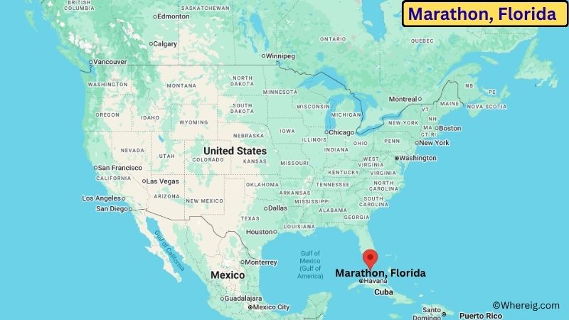
About Map: The map shows the location of Marathon in Monroe County, in the U.S. state of Florida.
Marathon Map, Florida
About Marathon Map: The Google Map highlights the location of Marathon in Monroe County, Florida. Use the zoom, satellite, and street-view options to explore the city's neighborhoods, roads, and nearby places.
Where is Marathon Located?
Marathon is a city located in Monroe County, Florida, the United States. It lies in the central Florida Keys, about 50 miles northeast of Key West and roughly 90 miles southwest of Miami by road. Marathon is located at approximately 24.727° North latitude and 81.038° West longitude. The 2020 Census recorded 9,690 residents, and the city covers about 9.68 square miles (25.07 sq km), much of it surrounded by water. Marathon was incorporated as a city in 1999 after several communities in the Middle Keys consolidated their local governments. The city includes parts of several islands, including Vaca Key, Boot Key, and Fat Deer Key. Its economy and daily life are strongly connected to the surrounding ocean, with boating, fishing, diving, tourism, and marine conservation playing important roles. Sombrero Beach is one of Marathon's best-known attractions and provides a sandy shoreline with swimming and views of the Atlantic. The Seven Mile Bridge, one of the Florida Keys' most recognizable structures, begins near the southern end of the Marathon area. A unique feature of Marathon is its location in the heart of the Middle Keys, making it a convenient base for exploring both the upper and lower island chains. The Florida Keys Overseas Highway, U.S. Route 1, is the primary road connecting Marathon with Key Largo, Key West, and the mainland.
Most Viewed US Maps
| USA Sttae Map | USA Region Map | USA Road Map |
| USA County Map | Where is USA in World Map? | US ZIP Code Map |
| USA Time Zones Map | US State and Capitals Map | USA Physical Map |
Find 4,400+ U.S. Cities by State - Explore Their Locations and Get Detailed Information
Marathon City Facts
| City | Marathon |
| State | Florida |
| County | Monroe County |
| Country | United States |
| Region | Florida Keys / South Florida |
| Incorporated | 1999 |
| Founded | 19th century |
| Total Area | 9.68 sq mi (25.07 sq km) |
| Land Area | 8.43 sq mi (21.83 sq km) |
| Water Area | 1.25 sq mi (3.24 sq km) |
| Elevation | About 7 ft (2 m) |
| Population (2023 estimate) | About 9,700 |
| Population (2020 Census) | 9,690 |
| Population Density | About 1,149 people per sq mi |
| Time Zone | Eastern Time (ET) |
| ZIP Codes | 33050, 33051, 33052 |
| Area Code | 305, 786 |
| Major Highways | U.S. Route 1 / Overseas Highway |
| Public Transit | Key West Transit and Monroe County transportation services |
| Major Attractions | Sombrero Beach, Seven Mile Bridge, Turtle Hospital, Crane Point Hammock, Florida Keys Aquarium Encounters |
| Official Website | https://www.ci.marathon.fl.us/ |
Distance from Marathon, FL to Nearby Cities
- Key Colony Beach, FL – 5 miles (8 km)
- Layton, FL – 20 miles (32 km)
- Islamorada, FL – 35 miles (56 km)
- Key Largo, FL – 55 miles (89 km)
- Big Pine Key, FL – 25 miles (40 km)
- Duck Key, FL – 10 miles (16 km)
- Marathon, FL – 0 miles (0 km)
- Stock Island, FL – 45 miles (72 km)
- Key West, FL – 50 miles (80 km)
- Bay Harbor Islands, FL – 90 miles (145 km)
- Homestead, FL – 105 miles (169 km)
- Miami, FL – 110 miles (177 km)
- Coral Gables, FL – 110 miles (177 km)
- Miami Beach, FL – 115 miles (185 km)
- Fort Lauderdale, FL – 140 miles (225 km)
Top Attractions in Marathon
- Sombrero Beach – A popular sandy beach in Marathon with swimming areas, picnic facilities, palm trees, and views of the Atlantic Ocean.
- Seven Mile Bridge – A historic and iconic bridge connecting the Middle Keys with the Lower Keys and offering expansive views over the water.
- The Turtle Hospital – A marine conservation center dedicated to rescuing, rehabilitating, and releasing injured sea turtles.
- Crane Point Hammock – A nature and cultural center with trails, native vegetation, historic sites, and exhibits about the Florida Keys.
- Florida Keys Aquarium Encounters – An interactive marine attraction featuring reef habitats, tropical fish, sharks, rays, and educational programs.
- Faro Blanco Lighthouse – A historic lighthouse landmark near the Marathon waterfront that reflects the area's maritime history.
- Florida Keys National Marine Sanctuary – A protected marine area surrounding the Keys with coral reefs, seagrass beds, mangroves, and abundant marine life.
- Bahia Honda State Park – A nearby island park known for beaches, snorkeling, kayaking, camping, and scenic views of the Florida Keys.
Airports Near Marathon
- Florida Keys Marathon International Airport (MTH) – 5 miles
- Key West International Airport (EYW) – 50 miles
- Miami Executive Airport (TMB) – 100 miles
- Miami International Airport (MIA) – 110 miles
- Fort Lauderdale-Hollywood International Airport (FLL) – 140 miles
Sources:
Population and area data sourced from the United States Census Bureau (2020 Census). General city information referenced from the official Marathon city website and local government records.
Florida Related Maps and Info
- Where is Miami
- Where is Hialeah
- Where is Jacksonville
- Where is Orlando
- Where is Saint Petersburg
- Where is Tampa
- Where is Alafaya
- Where is Boca Raton
- Where is Boynton Beach
- Where is Brandon
- Where is Cape Coral
- Where is Clearwater
- Where is Coral Springs
- Where is Davie
- Where is Daytona Beach
- Where is Deerfield Beach
- Where is Deltona
- Where is Doral
- Where is Fort Lauderdale
- Where is Fort Myers
- Where is Gainesville
- Where is Hollywood
- Where is Homestead
- Where is Horizon West
- Where is Kendall
- Where is Kissimmee
- Where is Lakeland
- Where is Largo
- Where is Lauderhill
- Where is Lehigh Acres
- Where is Melbourne
- Where is Miami Beach
- Where is Miami Gardens
- Where is Miramar
- Where is North Port
- Where is Palm Bay
- Where is Palm Coast
- Where is Pembroke Pines
- Where is Plantation
- Where is Poinciana
- Where is Pompano Beach
- Where is Port St. Lucie
- Where is Riverview
- Where is Spring Hill
- Where is St. Petersburg
- Where is Sunrise
- Where is Tallahassee
- Where is Tamarac
- Where is The Villages
- Where is Town 'n' Country
- Where is West Palm Beach