
Where is Moorhead Located? - Moorhead is a city located in the Clay County of Minnesota, United States. Moorhead lies between 48.1683058 Degrees North latitudes and 111.9447411 Degrees West longitudes.
Location Map of Moorhead, Minnesota
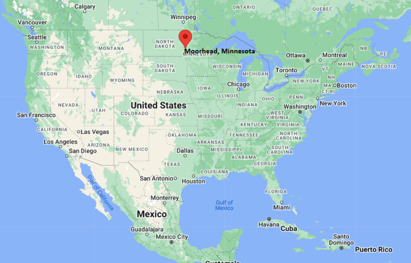
Moorhead Map, Minnesota, USA
Where is Moorhead?: The Google Map showing the location of Moorhead in the U.S. state of Minnesota.
Where is Moorhead Located?
Moorhead is a city located in the Clay County of Minnesota, United States. Moorhead lies between 48.1683058 Degrees North latitudes and 111.9447411 Degrees West longitudes. According to 2020 U.S.census, the population of Moorhead city is 44505 people and the city has a total area of 22.27 sq mi. The city has numerous parks and recreational facilities.
Most Viewed US Maps
| USA Sttae Map | USA Region Map | USA Road Map |
| USA County Map | Where is USA in World Map? | US ZIP Code Map |
| USA Time Zones Map | US State and Capitals Map | USA Physical Map |
Find 4,400+ U.S. Cities by State - Explore Their Locations and Get Detailed Information
Moorhead, Minnesota Quick Facts
| Attribute | Information |
|---|---|
| City | Moorhead |
| County | Clay County |
| State | Minnesota |
| State Capital | Saint Paul |
| US Region | Midwest (West North Central) |
| Latitude | 46.8739° N |
| Longitude | 96.7678° W |
| Elevation | 900 ft (274 m) |
| Land Area | 19.22 sq mi |
| Water Area | 0.20 sq mi |
| Total Area | 19.42 sq mi |
| Population (2020 Census) | 44,505 |
| Population Density | Approximately 2,316 per sq mi |
| ZIP Codes | 56560 |
| Area Code | 218 |
| Time Zone Standard | Central Standard Time (CST, UTC−6) |
| Time Zone Daylight | Central Daylight Time (CDT, UTC−5) |
| Currency | United States Dollar (USD) |
| FIPS Code | 27-43000 |
| Congressional District | Minnesota's 7th Congressional District |
Transportation and Connectivity in Moorhead
| Category | Information |
|---|---|
| Airport Name | Hector International Airport |
| IATA Code | FAR |
| Port | Not applicable |
| Major Highways | Interstate 94, U.S. Highway 10, U.S. Highway 75, Minnesota State Highway 336 |
| Train/Amtrak Service | Amtrak Empire Builder service at Fargo station |
| Local Bus/Transit Service | MATBUS (Moorhead Area Transit) |
- Interstate 94 – Major east–west interstate connecting Moorhead with Fargo, Minneapolis, and western North Dakota.
- U.S. Highway 10 – Regional highway connecting Moorhead with central Minnesota and North Dakota communities.
- U.S. Highway 75 – Historic north–south route serving the Red River Valley.
- Minnesota State Highway 336 – Local route providing access within the Moorhead area.
Top Places to Visit in Moorhead, Minnesota
| Landmark Name | Type |
|---|---|
| Hjemkomst Center | Museum and Cultural Center |
| Rourke Art Museum | Art Museum |
| Concordia College | Educational Landmark |
| Buffalo River State Park | State Park |
| Moorhead Center Mall | Shopping Center |
| Riverfront Park | Park |
| Memorial Auditorium | Historic Venue |
| Bluestem Center for the Arts | Performing Arts Center |
| Gooseberry Mound Park | Park |
| Comstock House | Historic House Museum |
Driving Distances from Moorhead, Minnesota to Nearby Cities
| City | State | Distance (mi) | Approx. Drive Time |
|---|---|---|---|
| Fargo | North Dakota | 3 | 10 minutes |
| West Fargo | North Dakota | 8 | 15 minutes |
| Dilworth | Minnesota | 5 | 10 minutes |
| Detroit Lakes | Minnesota | 45 | 50 minutes |
| Fergus Falls | Minnesota | 65 | 1 hour 10 minutes |
| Alexandria | Minnesota | 105 | 1 hour 45 minutes |
| Grand Forks | North Dakota | 75 | 1 hour 15 minutes |
| Bismarck | North Dakota | 190 | 3 hours |
| Minneapolis | Minnesota | 235 | 3 hours 30 minutes |
| Sioux Falls | South Dakota | 250 | 3 hours 45 minutes |
Colleges and Universities in Moorhead, Minnesota
| Institution Name | Type | Level | Notable For |
|---|---|---|---|
| Concordia College | Private | College | Liberal arts education and undergraduate programs |
| Minnesota State University Moorhead | Public | University | Teacher education, business, and arts programs |
| Moorhead Technical College | Public | Technical College | Career and technical education |
| North Dakota State University | Public | University | Agriculture, engineering, and research |
| Rasmussen University – Fargo Campus | Private | University | Health sciences and professional programs |
Waterbodies in Moorhead, Minnesota
Red River of the North, Goose River, Buffalo River, Oakport Creek, Lake Agassiz, Wild Rice River, Sheyenne River, Wolverton Creek.
Stadiums in Moorhead
Nemzek Field, Alex Nemzek Stadium, Scheels Field, Concordia College Jake Christiansen Stadium, Newman Outdoor Field.
Moorhead, Minnesota — Key Historical Facts
- Moorhead was founded in 1871 and named after William G. Moorhead, a railroad official connected with the area's early development.
- The city grew rapidly after the arrival of the Northern Pacific Railway, which helped establish Moorhead as a regional transportation center.
- Moorhead developed as an agricultural and educational hub in the Red River Valley.
- The Hjemkomst Center became a major cultural landmark after the construction and voyage of the Hjemkomst Viking ship in the 1980s.
- Today, Moorhead is known for its colleges, arts and culture, riverfront parks, and connection with the Fargo–Moorhead metropolitan area.
References
- City of Moorhead
- Clay County Government
- U.S. Census Bureau
- Minnesota State University Moorhead
- Explore Minnesota Tourism
Minnesota Related Maps and Info
- Where is Andover
- Where is Apple Valley
- Where is Blaine
- Where is Bloomington
- Where is Brooklyn Center
- Where is Brooklyn Park
- Where is Burnsville
- Where is Champlin
- Where is Chanhassen
- Where is Chaska
- Where is Coon Rapids
- Where is Cottage Grove
- Where is Crystal
- Where is Duluth
- Where is Eagan
- Where is Eden Prairie
- Where is Edina
- Where is Elk River
- Where is Faribault
- Where is Farmington
- Where is Fridley
- Where is Golden Valley
- Where is Inver Grove Heights
- Where is Lakeville
- Where is Mankato
- Where is Maple Grove
- Where is Maplewood
- Where is Minnetonka
- Where is Moorhead
- Where is New Brighton
- Where is Oakdale
- Where is Owatonna
- Where is Plymouth
- Where is Prior Lake
- Where is Ramsey
- Where is Richfield
- Where is Rosemount
- Where is Roseville
- Where is Savage
- Where is Shakopee
- Where is Shoreview
- Where is St. Cloud
- Where is St. Louis Park
- Where is St. Paul
- Where is White Bear Lake
- Where is Winona
- Where is Woodbury