
Where is Savage Located? - Savage is a city located in the Scott County of Minnesota, United States. Savage lies between 40.5862583 Degrees North latitudes and 98.3898726 Degrees West longitudes.
Location Map of Savage, Minnesota
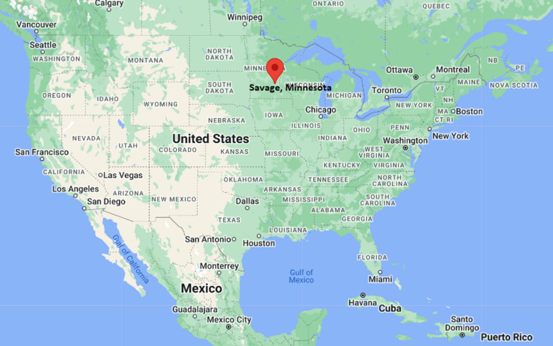
Savage Map, Minnesota, USA
Where is Savage?: The Google Map showing the location of Savage in the U.S. state of Minnesota.
Where is Savage Located?
Savage is a city located in the Scott County of Minnesota, United States. Savage lies between 40.5862583 Degrees North latitudes and 98.3898726 Degrees West longitudes. According to 2020 U.S.census, the population of Savage city is 32465 people and the city has a total area of 15.59 sq mi. The city has numerous parks and recreational facilities.
Most Viewed US Maps
| USA Sttae Map | USA Region Map | USA Road Map |
| USA County Map | Where is USA in World Map? | US ZIP Code Map |
| USA Time Zones Map | US State and Capitals Map | USA Physical Map |
Find 4,400+ U.S. Cities by State - Explore Their Locations and Get Detailed Information
Savage, Minnesota Quick Facts
| Attribute | Details |
|---|---|
| City | Savage |
| County | Scott County |
| State | Minnesota |
| State Capital | Saint Paul |
| US Region | Midwest |
| Latitude | 44.7797° N |
| Longitude | 93.3361° W |
| Elevation | Approximately 800 ft (244 m) |
| Land Area | 16.31 sq mi |
| Water Area | Approximately 0.46 sq mi |
| Total Area | Approximately 16.77 sq mi |
| Population (2020 Census) | 32,407 |
| Population Density | Approximately 1,987 per sq mi |
| ZIP Code | 55378 |
| Area Code | 952 |
| Time Zone Standard | Central Standard Time (CST), UTC−6 |
| Time Zone Daylight | Central Daylight Time (CDT), UTC−5 |
| Currency | United States Dollar (USD) |
| FIPS Code | 27-58276 |
| Congressional District | Minnesota's 2nd Congressional District |
Transportation and Connectivity in Savage, Minnesota
| Transportation Type | Details |
|---|---|
| Airport Name | Minneapolis-Saint Paul International Airport / Flying Cloud Airport |
| IATA Code | MSP / FCM |
| Port | Port of Savage on the Minnesota River |
| Major Highways | U.S. Highway 169, Minnesota State Highway 13, Minnesota State Highway 101 |
| Train Service | Freight rail service; regional passenger rail is available from nearby Twin Cities stations |
| Local Bus/Transit Service | SouthWest Transit and regional Twin Cities transit connections |
- U.S. Highway 169: Provides a major north-south connection between Savage, Shakopee, Bloomington, and the Minneapolis area.
- Minnesota State Highway 13: Connects Savage with Burnsville, Prior Lake, and other communities in the southern Twin Cities metropolitan area.
- Minnesota State Highway 101: Provides regional access toward Shakopee and western Scott County.
- Minnesota River: The river supports commercial transportation and industrial activity at the Port of Savage.
- Minneapolis-Saint Paul International Airport: Provides the nearest major commercial air service for Savage.
Top Places to Visit in Savage, Minnesota
| Landmark Name | Type |
|---|---|
| Murphy-Hanrehan Park Reserve | Regional Park and Recreation Area |
| Savage Community Park | Community Park and Recreation Area |
| Canterbury Park | Horse Racing and Entertainment Venue |
| Credit River | River and Natural Area |
| Minnesota River | River and Recreation Area |
| Eagle Creek Park | Community Park and Nature Area |
| Hidden Valley Park | Community Park and Recreation Area |
| McCann Park | Community Sports and Recreation Area |
| O'Connell Park | Community Sports and Recreation Area |
| Dan Patch Park | Historic and Community Park |
Driving Distances from Savage, Minnesota to Nearby Cities
| City | State | Distance (mi) | Approx. Drive Time |
|---|---|---|---|
| Burnsville | Minnesota | 7 mi | 10 minutes |
| Prior Lake | Minnesota | 5 mi | 10 minutes |
| Shakopee | Minnesota | 10 mi | 15 minutes |
| Eagan | Minnesota | 15 mi | 20 minutes |
| Lakeville | Minnesota | 12 mi | 20 minutes |
| Apple Valley | Minnesota | 10 mi | 15 minutes |
| Bloomington | Minnesota | 15 mi | 20 minutes |
| Minneapolis | Minnesota | 22 mi | 30 minutes |
| Saint Paul | Minnesota | 28 mi | 35 minutes |
| Rochester | Minnesota | 75 mi | 1 hour 15 minutes |
Colleges and Universities Near Savage, Minnesota
| Institution Name | Type | Level | Notable For |
|---|---|---|---|
| Normandale Community College | Public | Community College | Transfer programs, business, healthcare, technology, and liberal arts |
| University of Minnesota – Twin Cities | Public | University | Research, medicine, engineering, business, agriculture, and liberal arts |
| University of St. Thomas | Private | University | Business, engineering, education, law, and liberal arts |
| South Central College | Public | Community College | Career education, technical programs, healthcare, and transfer studies |
| Burnsville-Eagan-Savage School District 191 | Public | K–12 District | Primary and secondary education |
Waterbodies Near Savage, Minnesota
The Minnesota River, Credit River, Savage Lake, Eagle Creek, and nearby lakes and wetlands are important water features around Savage.
Golf Courses Near Savage
Hidden Greens Golf Course, Legends Golf Club, Crystal Lake Beach Golf, Valley View Golf Course, and Braemar Golf Course are among the golf facilities serving Savage and the southern Twin Cities area.
Savage, Minnesota — Key Historical Facts
- The Savage area was historically inhabited by Dakota people before European-American settlement.
- The community was originally known as Hamilton and was later renamed Savage after Marion Savage, a prominent businessman and racehorse owner.
- Marion Savage helped promote the famous racehorse Dan Patch, whose name became closely associated with the community.
- The town was incorporated in the late 19th century and developed as a transportation and agricultural community along the Minnesota River.
- Railroads and river transportation contributed to Savage's industrial development during the 19th and 20th centuries.
- Today, Savage is a growing suburban community in the southern Minneapolis-Saint Paul metropolitan area with extensive parks, trails, and access to the Minnesota River.
Stadiums and Sports Facilities Near Savage
| Facility Name | Type | Location |
|---|---|---|
| Savage Sports Dome | Indoor Sports Facility | Savage, Minnesota |
| Savage Community Park Sports Facilities | Community Sports Facility | Savage, Minnesota |
| Prior Lake High School Stadium | High School Sports Stadium | Prior Lake, Minnesota |
| Burnsville High School Sports Facilities | High School Sports Facility | Burnsville, Minnesota |
| Canterbury Park | Horse Racing and Events Facility | Shakopee, Minnesota |
References
- City of Savage Official Website
- Scott County Government
- U.S. Census Bureau
- Explore Minnesota Tourism
- Normandale Community College
Minnesota Related Maps and Info
- Where is Andover
- Where is Apple Valley
- Where is Blaine
- Where is Bloomington
- Where is Brooklyn Center
- Where is Brooklyn Park
- Where is Burnsville
- Where is Champlin
- Where is Chanhassen
- Where is Chaska
- Where is Coon Rapids
- Where is Cottage Grove
- Where is Crystal
- Where is Duluth
- Where is Eagan
- Where is Eden Prairie
- Where is Edina
- Where is Elk River
- Where is Faribault
- Where is Farmington
- Where is Fridley
- Where is Golden Valley
- Where is Inver Grove Heights
- Where is Lakeville
- Where is Mankato
- Where is Maple Grove
- Where is Maplewood
- Where is Minnetonka
- Where is Moorhead
- Where is New Brighton
- Where is Oakdale
- Where is Owatonna
- Where is Plymouth
- Where is Prior Lake
- Where is Ramsey
- Where is Richfield
- Where is Rosemount
- Where is Roseville
- Where is Savage
- Where is Shakopee
- Where is Shoreview
- Where is St. Cloud
- Where is St. Louis Park
- Where is St. Paul
- Where is White Bear Lake
- Where is Winona
- Where is Woodbury