
Where is Richfield Located? - Richfield is a city located in the Hennepin County of Minnesota, United States. Richfield lies between 40.9263957 Degrees North latitudes and 98.3420118 Degrees West longitudes.
Location Map of Richfield, Minnesota
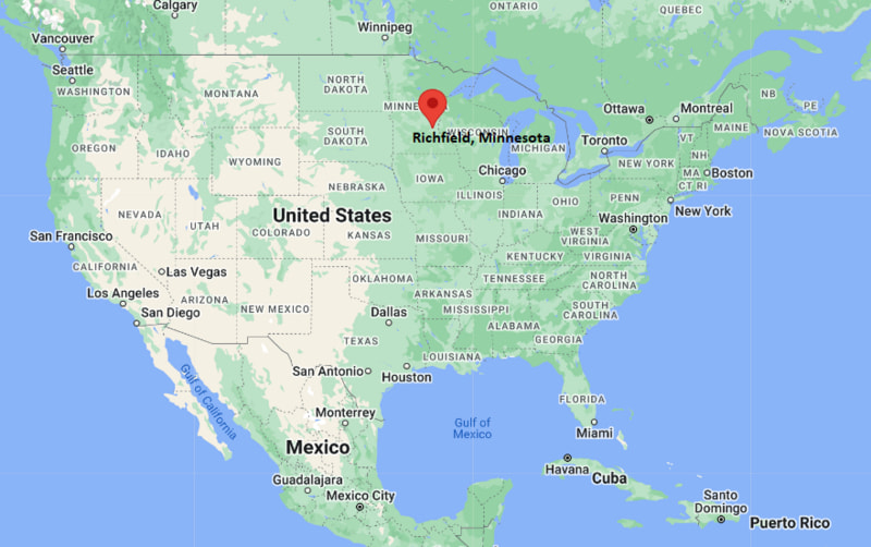
Richfield Map, Minnesota, USA
Where is Richfield?: The Google Map showing the location of Richfield in the U.S. state of Minnesota.
Where is Richfield Located?
Richfield is a city located in the Hennepin County of Minnesota, United States. Richfield lies between 40.9263957 Degrees North latitudes and 98.3420118 Degrees West longitudes. According to 2020 U.S.census, the population of Richfield city is 36994 people and the city has a total area of 6.72 sq mi. The city has numerous parks and recreational facilities.
Most Viewed US Maps
| USA Sttae Map | USA Region Map | USA Road Map |
| USA County Map | Where is USA in World Map? | US ZIP Code Map |
| USA Time Zones Map | US State and Capitals Map | USA Physical Map |
Find 4,400+ U.S. Cities by State - Explore Their Locations and Get Detailed Information
Richfield, Minnesota Quick Facts
| Attribute | Details |
|---|---|
| City | Richfield |
| County | Hennepin County |
| State | Minnesota |
| State Capital | Saint Paul |
| US Region | Midwestern United States (Upper Midwest Region) |
| Latitude | 44.8833° N |
| Longitude | 93.2833° W |
| Elevation | 830 ft (253 m) |
| Land Area | 6.90 sq mi |
| Water Area | 0.08 sq mi |
| Total Area | 6.98 sq mi |
| Population (2020 Census) | 36,994 |
| Population Density | Approximately 5,362 people per sq mi |
| ZIP Codes | 55423, 55424 |
| Area Code | 612 |
| Time Zone Standard | Central Standard Time (CST, UTC−6) |
| Time Zone Daylight | Central Daylight Time (CDT, UTC−5) |
| Currency | United States Dollar (USD) |
| FIPS Code | 27-54010 |
| Congressional District | Minnesota's 5th Congressional District |
Transportation and Connectivity in Richfield
| Category | Details |
|---|---|
| Airport Name | Minneapolis-Saint Paul International Airport |
| IATA Code | MSP |
| Regional Airport | Flying Cloud Airport |
| Major Highways | Interstate 35W, Interstate 494, Minnesota State Highway 62 |
| Train/Transit Service | Metro Transit Bus and Light Rail connections |
| Local Transit Service | Metro Transit |
- Interstate 35W – Major north-south freeway connecting Richfield with Minneapolis, Bloomington, and southern Minnesota communities.
- Interstate 494 – Beltway route providing access around the Minneapolis-Saint Paul metropolitan area.
- Minnesota State Highway 62 – Regional highway connecting Richfield with nearby suburbs and Minneapolis.
- Minneapolis-Saint Paul International Airport – Major airport located adjacent to Richfield and serving the Twin Cities region.
Top Places to Visit in Richfield, Minnesota
| Landmark Name | Type |
|---|---|
| Wood Lake Nature Center | Nature Preserve |
| Richfield Historical Society | History Organization |
| Veterans Memorial Park | Community Park |
| Taft Park | Recreation Park |
| Richfield Lake | Lake Recreation Area |
| Richfield Farmers Market | Local Market |
| The Hub Shopping Center | Shopping Area |
| Minnesota Valley National Wildlife Refuge | Wildlife Area |
| Minnehaha Falls | Natural Attraction |
| Mall of America | Shopping and Entertainment Complex |
Driving Distances from Richfield, Minnesota to Nearby Cities
| City | State | Distance (mi) | Approx. Drive Time |
|---|---|---|---|
| Minneapolis | Minnesota | 7 | 15 minutes |
| Bloomington | Minnesota | 5 | 10 minutes |
| Edina | Minnesota | 5 | 10 minutes |
| St. Louis Park | Minnesota | 8 | 15 minutes |
| Saint Paul | Minnesota | 15 | 25 minutes |
| Maple Grove | Minnesota | 25 | 35 minutes |
| Burnsville | Minnesota | 15 | 25 minutes |
| Woodbury | Minnesota | 30 | 40 minutes |
| Duluth | Minnesota | 155 | 2 hours 30 minutes |
| Rochester | Minnesota | 85 | 1 hour 30 minutes |
Colleges and Universities Near Richfield, Minnesota
| Institution Name | Type | Level | Notable For |
|---|---|---|---|
| Normandale Community College | Public | Community College | Transfer education, business, healthcare, and career programs |
| University of Minnesota Twin Cities | Public | University | Research, engineering, medicine, business, and academics |
| Augsburg University | Private | University | Liberal arts, business, education, and healthcare programs |
| Minneapolis College | Public | Community College | Career training, technology, and workforce education |
| Metropolitan State University | Public | University | Business, public service, education, and professional studies |
| Richfield Public Schools | Public | K–12 District | Primary and secondary education |
Waterbodies Near Richfield, Minnesota
Richfield Lake, Wood Lake, Lake Nokomis, Nine Mile Creek, Minnehaha Creek, and nearby waterways of Hennepin County.
Golf Courses Near Richfield
Richfield Golf Course, Braemar Golf Course, Hiawatha Golf Course, Meadowbrook Golf Course, and Edina Country Club.
Richfield, Minnesota — Key Historical Facts
- Richfield was first settled in the mid-nineteenth century and developed as an agricultural community near Minneapolis.
- The area was originally part of a large township that included farmland, forests, and lakes before urban development expanded.
- Richfield was incorporated as a village in 1908 and later became a city in 1950.
- The city experienced major suburban growth after World War II as housing development expanded throughout the Twin Cities metropolitan area.
- The construction of major highways, including Interstate 35W and Interstate 494, improved connections between Richfield and surrounding communities.
- Richfield is known for its parks, nature areas, diverse neighborhoods, and location between Minneapolis and Bloomington.
Stadiums and Sports Facilities Near Richfield
| Facility Name | Type | Location |
|---|---|---|
| Richfield High School Stadium | High School Sports Stadium | Richfield, Minnesota |
| 3M Arena at Mariucci | College Hockey Arena | Minneapolis, Minnesota |
| Williams Arena | College Sports Arena | Minneapolis, Minnesota |
| U.S. Bank Stadium | Football and Event Stadium | Minneapolis, Minnesota |
| Target Center | Sports and Entertainment Arena | Minneapolis, Minnesota |
References
- City of Richfield
- Hennepin County Government
- U.S. Census Bureau
- Minnesota Tourism
- Minnesota Department of Natural Resources
Minnesota Related Maps and Info
- Where is Andover
- Where is Apple Valley
- Where is Blaine
- Where is Bloomington
- Where is Brooklyn Center
- Where is Brooklyn Park
- Where is Burnsville
- Where is Champlin
- Where is Chanhassen
- Where is Chaska
- Where is Coon Rapids
- Where is Cottage Grove
- Where is Crystal
- Where is Duluth
- Where is Eagan
- Where is Eden Prairie
- Where is Edina
- Where is Elk River
- Where is Faribault
- Where is Farmington
- Where is Fridley
- Where is Golden Valley
- Where is Inver Grove Heights
- Where is Lakeville
- Where is Mankato
- Where is Maple Grove
- Where is Maplewood
- Where is Minnetonka
- Where is Moorhead
- Where is New Brighton
- Where is Oakdale
- Where is Owatonna
- Where is Plymouth
- Where is Prior Lake
- Where is Ramsey
- Where is Richfield
- Where is Rosemount
- Where is Roseville
- Where is Savage
- Where is Shakopee
- Where is Shoreview
- Where is St. Cloud
- Where is St. Louis Park
- Where is St. Paul
- Where is White Bear Lake
- Where is Winona
- Where is Woodbury