
Where is Lakeville Located? - Lakeville is a city located in the Dakota County of Minnesota, United States. Lakeville lies between 48.6330395 Degrees North latitudes and 112.3261618 Degrees West longitudes.
Location Map of Lakeville, Minnesota
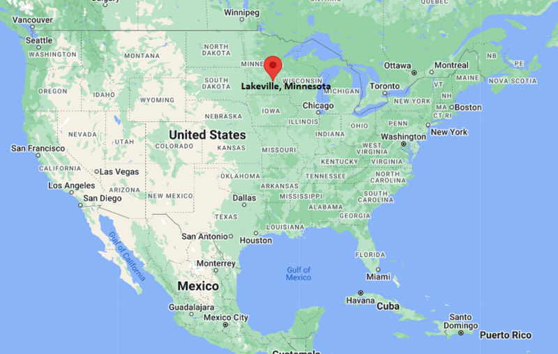
Lakeville Map, Minnesota, USA
Where is Lakeville?: The Google Map showing the location of Lakeville in the U.S. state of Minnesota.
Where is Lakeville Located?
Lakeville is a city located in the Dakota County of Minnesota, United States. Lakeville lies between 48.6330395 Degrees North latitudes and 112.3261618 Degrees West longitudes. According to 2020 U.S.census, the population of Lakeville city is 69490 people and the city has a total area of 36.32 sq mi. The city has numerous parks and recreational facilities.
Most Viewed US Maps
| USA Sttae Map | USA Region Map | USA Road Map |
| USA County Map | Where is USA in World Map? | US ZIP Code Map |
| USA Time Zones Map | US State and Capitals Map | USA Physical Map |
Find 4,400+ U.S. Cities by State - Explore Their Locations and Get Detailed Information
Lakeville, Minnesota Quick Facts
| Property | Details |
|---|---|
| City | Lakeville |
| County | Dakota County |
| State | Minnesota |
| State Capital | Saint Paul |
| US Region | Midwestern United States |
| Latitude | 44.6497° N |
| Longitude | 93.2427° W |
| Elevation | 1,060 ft (323 m) |
| Land Area | 37.68 sq mi |
| Water Area | 1.29 sq mi |
| Total Area | 38.97 sq mi |
| Population (2020 Census) | 69,490 |
| Population Density | Approximately 1,840 per sq mi |
| ZIP Code | 55044 |
| Area Code | 952 |
| Time Zone Standard | Central Standard Time (CST, UTC−6) |
| Time Zone Daylight | Central Daylight Time (CDT, UTC−5) |
| Currency | United States Dollar (USD) |
| FIPS Code | 27-34514 |
| Metropolitan Area | Minneapolis–Saint Paul–Bloomington Metropolitan Area |
Transportation and Connectivity in Lakeville
| Category | Details |
|---|---|
| Nearest Airport | Minneapolis–Saint Paul International Airport |
| IATA Code | MSP |
| Major Highways | Interstate 35, Interstate 35W, Interstate 35E, County Road 50, County Road 70 |
| Public Transit | Minnesota Valley Transit Authority (MVTA) |
| Nearest Rail Service | Amtrak Station in Saint Paul Union Depot |
| Regional Access | Excellent connectivity to Minneapolis, Saint Paul, Burnsville, Apple Valley, and the Twin Cities region |
- Interstate 35: Provides direct highway access to Minneapolis, Saint Paul, Duluth, and southern Minnesota.
- Minneapolis–Saint Paul International Airport: Located about 20 miles north, offering extensive domestic and international air service.
- MVTA Transit: Regional bus routes connect Lakeville with employment centers and transit hubs across the Twin Cities.
- Regional Transportation: Lakeville's location along Interstate 35 makes it one of the principal southern gateways to the Minneapolis–Saint Paul metropolitan area.
Top Places to Visit in Lakeville, Minnesota
| Landmark Name | Type |
|---|---|
| Antlers Park | Lakeside Park |
| Lake Marion | Recreational Lake |
| Casperson Park | Community Park |
| Ritter Farm Park | Historic Park |
| Steve Michaud Park | City Park |
| Murphy-Hanrehan Park Reserve | Regional Park |
| Whitetail Woods Regional Park | Nature Park |
| Ames Soccer Complex | Sports Complex |
| Crystal Lake Golf Club | Golf Course |
| Airlake Airport Observation Area | Scenic Spot |
Driving Distances from Lakeville, Minnesota to Nearby Cities
| City | State | Distance (mi) | Approx. Drive Time |
|---|---|---|---|
| Burnsville | Minnesota | 10 | 15 minutes |
| Apple Valley | Minnesota | 9 | 15 minutes |
| Farmington | Minnesota | 8 | 15 minutes |
| Prior Lake | Minnesota | 14 | 20 minutes |
| Eagan | Minnesota | 18 | 25 minutes |
| Bloomington | Minnesota | 20 | 25 minutes |
| Minneapolis | Minnesota | 27 | 35 minutes |
| Saint Paul | Minnesota | 30 | 35 minutes |
| Rochester | Minnesota | 72 | 1 hour 15 minutes |
| Mankato | Minnesota | 74 | 1 hour 20 minutes |
Colleges and Universities in and near Lakeville, Minnesota
| Institution Name | Type | Level | Notable For |
|---|---|---|---|
| Dakota County Technical College | Public | Technical College | Career and technical education, manufacturing, transportation, healthcare, and information technology |
| Inver Hills Community College | Public | Community College | Associate degrees, transfer programs, business, and liberal arts |
| Normandale Community College | Public | Community College | Transfer education, STEM programs, healthcare, and workforce development |
| University of St. Thomas | Private | University | Business, engineering, law, education, and graduate studies |
| University of Minnesota Twin Cities | Public | Research University | Engineering, medicine, agriculture, business, and scientific research |
Waterbodies in Lakeville, Minnesota
Lake Marion, Orchard Lake, Crystal Lake, Kingsley Lake, Lee Lake, East Lake, Mud Lake, Vermillion River
Stadiums in Lakeville
Lakeville North High School Panther Stadium, Lakeville South High School Cougar Stadium, Ames Soccer Complex, Ames Arena, Veterans Memorial Sports Complex
Lakeville, Minnesota — Key Historical Facts
- Lakeville was first settled in the 1850s and developed as an agricultural community along important regional transportation routes.
- The arrival of the railroad during the nineteenth century stimulated commercial growth and encouraged new settlement.
- The city was officially incorporated in 1880 and retained its strong agricultural character for much of the twentieth century.
- Rapid suburban development began in the 1980s and accelerated as the Minneapolis–Saint Paul metropolitan area expanded southward.
- Today, Lakeville is one of Minnesota's fastest-growing cities, recognized for its parks, lakes, excellent schools, and strong residential and commercial development.
References
- City of Lakeville
- Dakota County Government
- U.S. Census Bureau
- Dakota County Technical College
- Explore Minnesota
Minnesota Related Maps and Info
- Where is Andover
- Where is Apple Valley
- Where is Blaine
- Where is Bloomington
- Where is Brooklyn Center
- Where is Brooklyn Park
- Where is Burnsville
- Where is Champlin
- Where is Chanhassen
- Where is Chaska
- Where is Coon Rapids
- Where is Cottage Grove
- Where is Crystal
- Where is Duluth
- Where is Eagan
- Where is Eden Prairie
- Where is Edina
- Where is Elk River
- Where is Faribault
- Where is Farmington
- Where is Fridley
- Where is Golden Valley
- Where is Inver Grove Heights
- Where is Lakeville
- Where is Mankato
- Where is Maple Grove
- Where is Maplewood
- Where is Minnetonka
- Where is Moorhead
- Where is New Brighton
- Where is Oakdale
- Where is Owatonna
- Where is Plymouth
- Where is Prior Lake
- Where is Ramsey
- Where is Richfield
- Where is Rosemount
- Where is Roseville
- Where is Savage
- Where is Shakopee
- Where is Shoreview
- Where is St. Cloud
- Where is St. Louis Park
- Where is St. Paul
- Where is White Bear Lake
- Where is Winona
- Where is Woodbury