
St. Marys is a coastal city in southeastern Georgia and the county seat of Camden County. Located about 40 miles north of Jacksonville, Florida, the city sits along the St. Marys River near Cumberland Island. It is known for its waterfront, historic district, Cumberland Island National Seashore, and maritime heritage.
Location Map of St. Marys, Camden County, Georgia
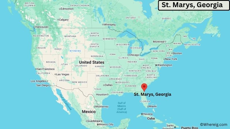
About Map: The map shows the location of St. Marys in Camden County, in the U.S. state of Georgia.
St. Marys Map, Georgia
About St. Marys Map: The Google Map highlights the location of St. Marys in Camden County, Georgia. Use the zoom, satellite, and street-view options to explore the city's neighborhoods, roads, and nearby places.
Where is St. Marys Located?
St. Marys is a city located in Camden County, Georgia, the United States. It lies on the southeastern Georgia coast along the St. Marys River, about 40 miles north of Jacksonville, Florida, and roughly 55 miles south of Brunswick, Georgia. Kingsland is about 10 miles west, while Fernandina Beach, Florida, is approximately 20 miles south. The city is located at 30.7306° North latitude and 81.5463° West longitude. The 2020 Census recorded 18,338 residents. St. Marys covers about 24.08 square miles, or approximately 62.37 square kilometers. The waterfront is one of the city's defining geographic features, with the St. Marys River separating Georgia from Florida near the Atlantic coast. The city is also the main mainland gateway to Cumberland Island National Seashore, known for its beaches, maritime forests, wild horses, and historic sites. St. Marys has a long maritime history and was settled during Georgia's colonial period. A unique feature of the city is its position beside the southernmost Georgia coast and its close connection to Cumberland Island and the Atlantic Intracoastal Waterway.
Most Viewed US Maps
| USA Sttae Map | USA Region Map | USA Road Map |
| USA County Map | Where is USA in World Map? | US ZIP Code Map |
| USA Time Zones Map | US State and Capitals Map | USA Physical Map |
Find 4,400+ U.S. Cities by State - Explore Their Locations and Get Detailed Information
St. Marys City Facts
| Fact | Details |
|---|---|
| City | St. Marys |
| State | Georgia |
| County | Camden County |
| Country | United States |
| Region | Southeastern Georgia, Georgia Coast |
| Incorporated | 1808 |
| Founded | 1787 |
| Total Area | 24.08 sq mi (62.37 sq km) |
| Land Area | 22.34 sq mi (57.86 sq km) |
| Water Area | 1.74 sq mi (4.51 sq km) |
| Elevation | About 20 ft (6 m) |
| Population (2023 estimate) | About 18,700 |
| Population (2020 Census) | 18,338 |
| Population Density | About 821 people per sq mi |
| Time Zone | Eastern Time (EST/EDT) |
| ZIP Codes | 31558 |
| Area Code | 912 |
| Major Highways | U.S. Highway 17, Georgia State Route 40, Interstate 95 |
| Public Transit | Camden County community transportation services |
| Major Attractions | Cumberland Island National Seashore, St. Marys Historic District, St. Marys Waterfront, St. Marys Submarine Museum, Crooked River State Park |
| Official Website | https://www.stmarysga.gov/ |
Distance from St. Marys, GA to Nearby Cities
- Kingsland, GA – 10 miles (16 km)
- Woodbine, GA – 15 miles (24 km)
- Fernandina Beach, FL – 20 miles (32 km)
- Yulee, FL – 20 miles (32 km)
- Folkston, GA – 30 miles (48 km)
- Jacksonville, FL – 40 miles (64 km)
- Brunswick, GA – 55 miles (89 km)
- Waycross, GA – 60 miles (97 km)
- St. Simons Island, GA – 65 miles (105 km)
- Darien, GA – 75 miles (121 km)
- Jesup, GA – 65 miles (105 km)
- St. Augustine, FL – 75 miles (121 km)
- Savannah, GA – 110 miles (177 km)
- Valdosta, GA – 115 miles (185 km)
- Daytona Beach, FL – 150 miles (241 km)
- Gainesville, FL – 155 miles (249 km)
- Orlando, FL – 180 miles (290 km)
- Atlanta, GA – 300 miles (483 km)
Top Attractions in St. Marys
- Cumberland Island National Seashore – A protected barrier island known for undeveloped beaches, maritime forests, salt marshes, wildlife, wild horses, and historic sites.
- St. Marys Submarine Museum – A museum highlighting the history of U.S. Navy submarines and the nearby Naval Submarine Base Kings Bay.
- St. Marys Historic District – A historic downtown area with preserved homes, churches, civic buildings, and streets reflecting the city's coastal heritage.
- St. Marys Waterfront Park – A scenic waterfront area along the St. Marys River with walking paths, green space, river views, and access to local attractions.
- St. Marys Howard Gilman Memorial Waterfront Park – A popular community park offering views of the river and nearby coastal landscape.
- Crooked River State Park – A nearby coastal state park with camping, hiking trails, fishing, boating access, and views of salt marshes and maritime forests.
- St. Marys Aquatic Center – A community recreation facility with swimming and family activities.
- St. Marys Railroad – A historic railroad connection that reflects the city's transportation and industrial development.
- Cumberland Island National Seashore Visitor Center – The main mainland visitor facility for planning trips to Cumberland Island and learning about its natural and cultural resources.
Airports Near St. Marys, Georgia
- Jacksonville International Airport (JAX) – 30 miles
- Northeast Florida Regional Airport (UST) – 65 miles
- Brunswick Golden Isles Airport (BQK) – 65 miles
- Waycross-Ware County Airport (AYS) – 65 miles
- Savannah/Hilton Head International Airport (SAV) – 110 miles
Sources:
Population and area data sourced from the United States Census Bureau (2020 Census). General city information referenced from the official St. Marys city website and local government records.
Most Viewed GA Maps
- Where is Acworth
- Where is Albany
- Where is Alpharetta
- Where is Candler-McAfee
- Where is Canton
- Where is Carrollton
- Where is Cartersville
- Where is Chamblee
- Where is Dalton
- Where is Decatur
- Where is Douglasville
- Where is Duluth
- Where is Dunwoody
- Where is East Point
- Where is Evans
- Where is Gainesville
- Where is Griffin
- Where is Hinesville
- Where is Johns Creek
- Where is Kennesaw
- Where is LaGrange
- Where is Lawrenceville
- Where is Mableton
- Where is Marietta
- Where is Martinez
- Where is McDonough
- Where is Milton
- Where is Newnan
- Where is Peachtree City
- Where is Perry
- Where is Pooler
- Where is Redan
- Where is Rome
- Where is Roswell
- Where is Sandy Springs
- Where is Savannah
- Where is Smyrna
- Where is Snellville
- Where is Statesboro
- Where is Stockbridge
- Where is Sugar Hill
- Where is Suwanee
- Where is Union City
- Where is Valdosta
- Where is Warner Robins
- Where is Woodstock