
Waterloo is a city in southwestern Illinois and the county seat of Monroe County. It is about 25 miles south of St. Louis and 15 miles north of Waterloo, Missouri. Located in the St. Louis metropolitan area, Waterloo is known for its German heritage, historic courthouse square, and nearby outdoor areas such as Valmeyer and the Mississippi River bluffs.
Location Map of Waterloo, Monroe County, Illinois
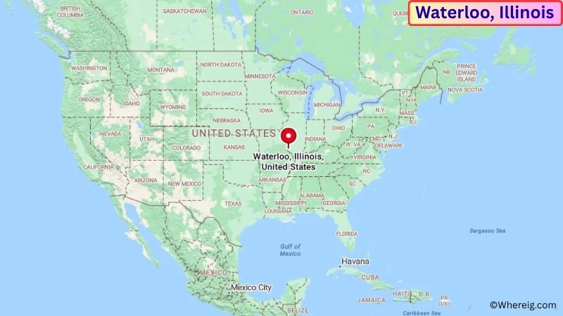
About Map: The map shows the location of Waterloo in Monroe County, in the U.S. state of Illinois.
Waterloo Map, Illinois
About Waterloo Map: The Google Map highlights the location of Waterloo in Monroe County, Illinois. Use the zoom, satellite, and street-view options to explore the city's neighborhoods, roads, and nearby places.
Where is Waterloo Located?
Waterloo is a city located in Monroe County, Illinois, the United States. It is in southwestern Illinois, about 25 miles south of St. Louis, Missouri, 15 miles west of Belleville, and roughly 30 miles east of Columbia, Missouri. Waterloo lies at approximately 38.335° North latitude and 90.150° West longitude. The city had 10,757 residents in the 2020 Census and covers about 7.86 square miles, or 20.36 square kilometers. Waterloo was founded in the early 19th century and became the county seat of Monroe County. German immigrants played an important role in the city's development, and that heritage remains visible in local traditions, architecture, and community events. The historic downtown square is one of Waterloo's best-known landmarks and serves as the center of local government and commerce. Nearby attractions include the Mississippi River, Salt Lick Point Land & Water Reserve, and the historic communities of Maeystown and Valmeyer. Illinois Route 3 and Interstate 255 provide convenient connections to St. Louis and communities throughout the Metro East region.
Most Viewed US Maps
| USA Sttae Map | USA Region Map | USA Road Map |
| USA County Map | Where is USA in World Map? | US ZIP Code Map |
| USA Time Zones Map | US State and Capitals Map | USA Physical Map |
Find 4,400+ U.S. Cities by State - Explore Their Locations and Get Detailed Information
Waterloo City Facts
| Fact | Details |
|---|---|
| City | Waterloo |
| State | Illinois |
| County | Monroe County |
| Country | United States |
| Region | Metro East / Southwestern Illinois |
| Incorporated | 1859 |
| Founded | 1818 |
| Total Area | 7.86 sq mi (20.36 sq km) |
| Land Area | 7.80 sq mi (20.20 sq km) |
| Water Area | 0.06 sq mi (0.16 sq km) |
| Elevation | Approximately 450 ft (137 m) |
| Population (2023 estimate) | Approximately 10,900 |
| Population (2020 Census) | 10,757 |
| Population Density | Approximately 1,379 people per sq mi |
| Time Zone | Central Time Zone (CST/CDT) |
| ZIP Codes | 62298 |
| Area Code | 618, 730 |
| Major Highways | Illinois Route 3, Illinois Route 156, Interstate 255 |
| Public Transit | Monroe-Randolph Transit District |
| Major Attractions | Historic Waterloo Square, Monroe County Courthouse, Salt Lick Point, Maeystown Historic District |
| Official Website | https://www.waterloo.il.us/ |
Distance from Waterloo, IL to Nearby Cities
- Columbia, IL – 8 miles (13 km)
- Valmeyer, IL – 8 miles (13 km)
- Red Bud, IL – 15 miles (24 km)
- Belleville, IL – 15 miles (24 km)
- Freeburg, IL – 15 miles (24 km)
- Shiloh, IL – 20 miles (32 km)
- Edwardsville, IL – 25 miles (40 km)
- East St. Louis, IL – 22 miles (35 km)
- St. Louis, MO – 25 miles (40 km)
- Chester, IL – 35 miles (56 km)
- Alton, IL – 40 miles (64 km)
- Centralia, IL – 55 miles (89 km)
- Carbondale, IL – 65 miles (105 km)
- Jackson, MO – 75 miles (121 km)
- Cape Girardeau, MO – 75 miles (121 km)
- Springfield, IL – 90 miles (145 km)
- Columbia, MO – 110 miles (177 km)
- Decatur, IL – 115 miles (185 km)
Top Attractions in Waterloo
- Historic Waterloo Square – The city's central historic district features the county courthouse, older commercial buildings, local businesses, and community gathering spaces.
- Monroe County Courthouse – A prominent civic landmark in the center of Waterloo reflecting the city's long history as the county seat.
- Monroe County Historical Museum – A local museum preserving artifacts, photographs, documents, and stories from Waterloo and the surrounding county.
- Salt Lick Point Land & Water Reserve – A nearby natural area featuring wooded bluffs, hiking trails, limestone geology, and views across the Mississippi River valley.
- Maeystown Historic District – A nearby historic village known for German heritage, preserved 19th-century buildings, local shops, and community festivals.
- Valmeyer – A nearby community surrounded by limestone bluffs and natural areas, offering access to hiking and scenic landscapes.
- Mississippi River – The river lies west of Waterloo and provides opportunities for fishing, boating, birdwatching, and enjoying the wooded river bluffs.
- Fort de Chartres State Historic Site – A historic French colonial fort near Prairie du Rocher preserving important early Illinois history.
- Cahokia Mounds State Historic Site – A major archaeological site near Collinsville preserving the remains of one of the largest pre-Columbian settlements in North America.
- Gateway Arch National Park – A major landmark across the Mississippi River in St. Louis featuring the Gateway Arch and museums about the westward expansion of the United States.
Airports Near Waterloo, IL
- St. Louis Downtown Airport (CPS) – 25 miles
- MidAmerica St. Louis Airport (BLV) – 30 miles
- Spirit of St. Louis Airport (SUS) – 40 miles
- St. Louis Lambert International Airport (STL) – 45 miles
- Veterans Airport of Southern Illinois (MWA) – 65 miles
Sources:
Population and area data sourced from the United States Census Bureau (2020 Census). General city information referenced from the official City of Waterloo website and local government records.
Illinois Related Maps and Info
- Where is Arlington Heights
- Where is Bartlett
- Where is Belleville
- Where is Berwyn
- Where is Bloomington
- Where is Bolingbrook
- Where is Buffalo Grove
- Where is Carol Stream
- Where is Carpentersville
- Where is Champaign
- Where is Cicero
- Where is Crystal Lake
- Where is Decatur
- Where is DeKalb
- Where is Des Plaines
- Where is Downers Grove
- Where is Elgin
- Where is Elmhurst
- Where is Evanston
- Where is Glenview
- Where is Hanover Park
- Where is Hoffman Estates
- Where is Joliet
- Where is Lombard
- Where is Moline
- Where is Mount Prospect
- Where is Naperville
- Where is Normal
- Where is Oak Lawn
- Where is Oak Park
- Where is Orland Park
- Where is Palatine
- Where is Park Ridge
- Where is Peoria
- Where is Plainfield
- Where is Quincy
- Where is Rock Island
- Where is Rockford
- Where is Romeoville
- Where is Schaumburg
- Where is Skokie
- Where is Streamwood
- Where is Tinley Park
- Where is Urbana
- Where is Waukegan
- Where is Wheaton
- Where is Wheeling