
Waycross is a city in southeast Georgia and the county seat of Ware County. It is about 75 miles west of Brunswick and 90 miles north of Jacksonville, Florida. Located near the Okefenokee Swamp, Waycross is known for its railroad history, historic downtown, and access to one of the largest wetland areas in North America.
Location Map of Waycross, Pierce County, Georgia
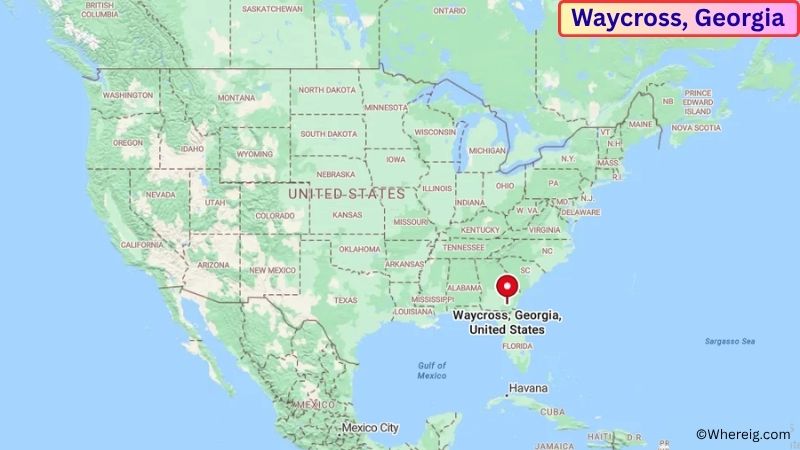
About Map: The map shows the location of Waycross in Pierce County, in the U.S. state of Georgia.
Waycross Map, Georgia
About Waycross Map: The Google Map highlights the location of Waycross in Pierce County, Georgia. Use the zoom, satellite, and street-view options to explore the city's neighborhoods, roads, and nearby places.
Where is Waycross Located?
Waycross is a city located in Ware County, Georgia, the United States. It is in southeast Georgia, about 75 miles west of Brunswick, 90 miles north of Jacksonville, Florida, and roughly 80 miles southeast of Valdosta. Waycross lies at approximately 31.213° North latitude and 82.354° West longitude. The city had 13,942 residents in the 2020 Census and covers about 11.37 square miles, or 29.55 square kilometers. Waycross was incorporated in 1874 and developed rapidly as a railroad center because several important rail lines met in the area. The city's railroad heritage remains an important part of its identity. Waycross is also one of the main gateways to the Okefenokee National Wildlife Refuge, a vast wetland famous for cypress forests, blackwater channels, wildlife, and canoeing. The nearby Okefenokee Swamp Park offers another way to explore the area's natural environment. Downtown Waycross includes historic buildings, local businesses, and landmarks connected to the city's railroad past. U.S. Route 1, U.S. Route 23, U.S. Route 82, and U.S. Route 84 provide major road connections across southern Georgia and into Florida.
Most Viewed US Maps
| USA Sttae Map | USA Region Map | USA Road Map |
| USA County Map | Where is USA in World Map? | US ZIP Code Map |
| USA Time Zones Map | US State and Capitals Map | USA Physical Map |
Find 4,400+ U.S. Cities by State - Explore Their Locations and Get Detailed Information
Waycross City Facts
| Fact | Details |
|---|---|
| City | Waycross |
| State | Georgia |
| County | Ware County |
| Country | United States |
| Region | Southeast Georgia |
| Incorporated | 1874 |
| Founded | 1873 |
| Total Area | 11.37 sq mi (29.45 sq km) |
| Land Area | 11.25 sq mi (29.14 sq km) |
| Water Area | 0.12 sq mi (0.31 sq km) |
| Elevation | Approximately 80 ft (24 m) |
| Population (2023 estimate) | Approximately 13,500 |
| Population (2020 Census) | 13,942 |
| Population Density | Approximately 1,239 people per sq mi |
| Time Zone | Eastern Time Zone (EST/EDT) |
| ZIP Codes | 31501, 31502, 31503 |
| Area Code | 912 |
| Major Highways | U.S. Route 1, U.S. Route 23, U.S. Route 82, U.S. Route 84, Georgia State Route 4 |
| Public Transit | Coastal Regional Commission regional transit services |
| Major Attractions | Okefenokee Swamp Park, Okefenokee National Wildlife Refuge, Southern Forest World, Historic Downtown Waycross |
| Official Website | https://www.waycrossga.gov/ |
Distance from Waycross, GA to Nearby Cities
- Blackshear, GA – 15 miles (24 km)
- Homerville, GA – 25 miles (40 km)
- Folkston, GA – 30 miles (48 km)
- Jesup, GA – 30 miles (48 km)
- Douglas, GA – 40 miles (64 km)
- Nahunta, GA – 35 miles (56 km)
- Hazlehurst, GA – 55 miles (89 km)
- Brunswick, GA – 75 miles (121 km)
- Valdosta, GA – 80 miles (129 km)
- St. Marys, GA – 65 miles (105 km)
- Hinesville, GA – 70 miles (113 km)
- Savannah, GA – 95 miles (153 km)
- Jacksonville, FL – 90 miles (145 km)
- Fernandina Beach, FL – 75 miles (121 km)
- St. Augustine, FL – 125 miles (201 km)
- Tifton, GA – 75 miles (121 km)
- Albany, GA – 100 miles (161 km)
- Macon, GA – 135 miles (217 km)
Top Attractions in Waycross
- Okefenokee Swamp Park – A major nature attraction near Waycross offering boat tours, boardwalks, wildlife viewing, educational exhibits, and access to the Okefenokee wetlands.
- Okefenokee National Wildlife Refuge – A vast protected wetland famous for cypress forests, blackwater waterways, alligators, birds, turtles, and other wildlife.
- Southern Forest World – A museum dedicated to the history of forestry and the forest products industry in the Southeast.
- Historic Downtown Waycross – The downtown area contains historic buildings, local businesses, restaurants, and landmarks connected to the city's railroad history.
- Laura S. Walker State Park – A nearby state park featuring a lake, hiking trails, camping, fishing, boating, and views of the coastal plain landscape.
- Okefenokee National Wildlife Refuge Visitor Center – A visitor facility providing information about the swamp, wildlife, trails, and recreational opportunities.
- Ware County Courthouse – A historic civic landmark in downtown Waycross that reflects the city's role as the county seat.
- Satilla River – A nearby blackwater river offering opportunities for fishing, paddling, wildlife viewing, and scenic recreation.
- Waycross Railroad Heritage Area – Sites around the city reflect the important role that railroads played in Waycross's growth and regional development.
- Okefenokee Wilderness – The protected wilderness areas surrounding the swamp provide opportunities for canoeing, hiking, photography, and wildlife observation.
Airports Near Waycross, GA
- Waycross-Ware County Airport (AYS) – 5 miles
- Jacksonville International Airport (JAX) – 75 miles
- Brunswick Golden Isles Airport (BQK) – 80 miles
- Valdosta Regional Airport (VLD) – 85 miles
- Savannah/Hilton Head International Airport (SAV) – 100 miles
Sources:
Population and area data sourced from the United States Census Bureau (2020 Census). General city information referenced from the official City of Waycross website and local government records.
Most Viewed GA Maps
- Where is Acworth
- Where is Albany
- Where is Alpharetta
- Where is Candler-McAfee
- Where is Canton
- Where is Carrollton
- Where is Cartersville
- Where is Chamblee
- Where is Dalton
- Where is Decatur
- Where is Douglasville
- Where is Duluth
- Where is Dunwoody
- Where is East Point
- Where is Evans
- Where is Gainesville
- Where is Griffin
- Where is Hinesville
- Where is Johns Creek
- Where is Kennesaw
- Where is LaGrange
- Where is Lawrenceville
- Where is Mableton
- Where is Marietta
- Where is Martinez
- Where is McDonough
- Where is Milton
- Where is Newnan
- Where is Peachtree City
- Where is Perry
- Where is Pooler
- Where is Redan
- Where is Rome
- Where is Roswell
- Where is Sandy Springs
- Where is Savannah
- Where is Smyrna
- Where is Snellville
- Where is Statesboro
- Where is Stockbridge
- Where is Sugar Hill
- Where is Suwanee
- Where is Union City
- Where is Valdosta
- Where is Warner Robins
- Where is Woodstock