
West Frankfort is a city in southern Illinois, located in Franklin County in the heart of the state's coal country. It is about 15 miles south of Benton and 50 miles southeast of Mount Vernon. The city has deep roots in coal mining and railroad transportation, while nearby Rend Lake and the Shawnee National Forest provide access to fishing, hiking, boating, and other outdoor activities.
Location Map of West Frankfort, Franklin County, Illinois
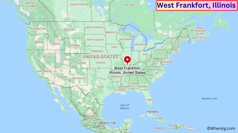
About Map: The map shows the location of West Frankfort in Franklin County, in the U.S. state of Illinois.
West Frankfort Map, Illinois
About West Frankfort Map: The Google Map highlights the location of West Frankfort in Franklin County, Illinois. Use the zoom, satellite, and street-view options to explore the city's neighborhoods, roads, and nearby places.
Where is West Frankfort Located?
West Frankfort is a city located in Franklin County, Illinois, the United States. It is in southern Illinois, about 15 miles south of Benton, 25 miles west of Harrisburg, and roughly 50 miles southeast of Mount Vernon. West Frankfort lies at approximately 37.899° North latitude and 88.933° West longitude. The city had 7,178 residents in the 2020 Census and covers about 5.26 square miles, or 13.62 square kilometers. West Frankfort was founded in the 19th century and grew rapidly because of the region's coal mines and railroad connections. Coal mining became the foundation of the local economy and shaped the city's neighborhoods, businesses, and transportation network for much of the 20th century. Today, the city preserves parts of this industrial heritage while serving as a regional community in southern Illinois. Rend Lake is a major nearby recreation destination, offering boating, fishing, swimming, camping, and hiking. The Shawnee National Forest also provides access to forests, lakes, rock formations, and scenic trails. Interstate 57 and Illinois Route 149 provide convenient connections to Marion, Carbondale, Mount Vernon, and other communities across southern Illinois.
Most Viewed US Maps
| USA Sttae Map | USA Region Map | USA Road Map |
| USA County Map | Where is USA in World Map? | US ZIP Code Map |
| USA Time Zones Map | US State and Capitals Map | USA Physical Map |
Find 4,400+ U.S. Cities by State - Explore Their Locations and Get Detailed Information
West Frankfort City Facts
| Fact | Details |
|---|---|
| City | West Frankfort |
| State | Illinois |
| County | Franklin County |
| Country | United States |
| Region | Southern Illinois |
| Incorporated | 1891 |
| Founded | 1870s |
| Total Area | 5.26 sq mi (13.62 sq km) |
| Land Area | 5.25 sq mi (13.60 sq km) |
| Water Area | 0.01 sq mi (0.03 sq km) |
| Elevation | Approximately 420 ft (128 m) |
| Population (2023 estimate) | Approximately 7,000 |
| Population (2020 Census) | 7,178 |
| Population Density | Approximately 1,368 people per sq mi |
| Time Zone | Central Time Zone (CST/CDT) |
| ZIP Codes | 62896 |
| Area Code | 618, 730 |
| Major Highways | Interstate 57, Illinois Route 149, Illinois Route 37 |
| Public Transit | South Central Illinois Mass Transit District |
| Major Attractions | Franklin County Coal Miners Memorial, Rend Lake, West Frankfort Historical Museum, Shawnee National Forest |
| Official Website | https://www.westfrankfort-il.com/ |
Distance from West Frankfort, IL to Nearby Cities
- Benton, IL – 15 miles (24 km)
- Johnston City, IL – 10 miles (16 km)
- Marion, IL – 15 miles (24 km)
- Harrisburg, IL – 25 miles (40 km)
- Herrin, IL – 12 miles (19 km)
- Du Quoin, IL – 25 miles (40 km)
- Carbondale, IL – 30 miles (48 km)
- Mount Vernon, IL – 50 miles (80 km)
- Murphysboro, IL – 30 miles (48 km)
- Centralia, IL – 55 miles (89 km)
- Anna, IL – 50 miles (80 km)
- Metropolis, IL – 50 miles (80 km)
- Cape Girardeau, MO – 55 miles (89 km)
- Paducah, KY – 55 miles (89 km)
- Fairfield, IL – 55 miles (89 km)
- Mount Carmel, IL – 70 miles (113 km)
- Evansville, IN – 95 miles (153 km)
- St. Louis, MO – 115 miles (185 km)
Top Attractions in West Frankfort
- Franklin County Coal Miners Memorial – A local memorial honoring miners and remembering the important role coal mining played in the history of West Frankfort and surrounding communities.
- West Frankfort Historical Museum – A local museum preserving photographs, artifacts, documents, and stories connected to the city's coal-mining and community history.
- Rend Lake – A large nearby reservoir offering boating, fishing, swimming, camping, hiking, and wildlife viewing.
- Rend Lake College Foundation Museum – A nearby educational and cultural resource featuring local history and regional exhibits.
- Shawnee National Forest – A large forested area in southern Illinois with hiking trails, lakes, cliffs, rock formations, camping, and wildlife habitats.
- Garden of the Gods Recreation Area – A popular Shawnee National Forest destination known for dramatic sandstone rock formations, overlooks, and hiking trails.
- Crab Orchard National Wildlife Refuge – A large protected area near Carbondale featuring lakes, wetlands, forests, wildlife habitat, fishing, boating, and hiking.
- Little Grand Canyon – A scenic canyon in the Shawnee National Forest featuring sandstone cliffs, wooded trails, waterfalls, and overlooks.
- Crenshaw House – A historic site near Equality associated with the antebellum period and the history of slavery in southern Illinois.
- Southern Illinois Miners Heritage Museum – Regional exhibits and historic sites throughout the area preserve the story of coal mining and the communities that developed around it.
Airports Near West Frankfort, IL
- Veterans Airport of Southern Illinois (MWA) – 20 miles
- Williamson County Regional Airport (MWA) – 20 miles
- Marion Municipal Airport (JYM) – 15 miles
- Mount Vernon Airport (MVN) – 50 miles
- Barkley Regional Airport (PAH) – 60 miles
Sources:
Population and area data sourced from the United States Census Bureau (2020 Census). General city information referenced from the official City of West Frankfort website and local government records.
Illinois Related Maps and Info
- Where is Arlington Heights
- Where is Bartlett
- Where is Belleville
- Where is Berwyn
- Where is Bloomington
- Where is Bolingbrook
- Where is Buffalo Grove
- Where is Carol Stream
- Where is Carpentersville
- Where is Champaign
- Where is Cicero
- Where is Crystal Lake
- Where is Decatur
- Where is DeKalb
- Where is Des Plaines
- Where is Downers Grove
- Where is Elgin
- Where is Elmhurst
- Where is Evanston
- Where is Glenview
- Where is Hanover Park
- Where is Hoffman Estates
- Where is Joliet
- Where is Lombard
- Where is Moline
- Where is Mount Prospect
- Where is Naperville
- Where is Normal
- Where is Oak Lawn
- Where is Oak Park
- Where is Orland Park
- Where is Palatine
- Where is Park Ridge
- Where is Peoria
- Where is Plainfield
- Where is Quincy
- Where is Rock Island
- Where is Rockford
- Where is Romeoville
- Where is Schaumburg
- Where is Skokie
- Where is Streamwood
- Where is Tinley Park
- Where is Urbana
- Where is Waukegan
- Where is Wheaton
- Where is Wheeling