Map of York County - York County is a county located in the U.S. state of Maine. York County Map showing cities, highways, important places and water bodies. Get Where is York County located in the map, major cities in York county, population, areas, and places of interest.
Map of York County, Maine
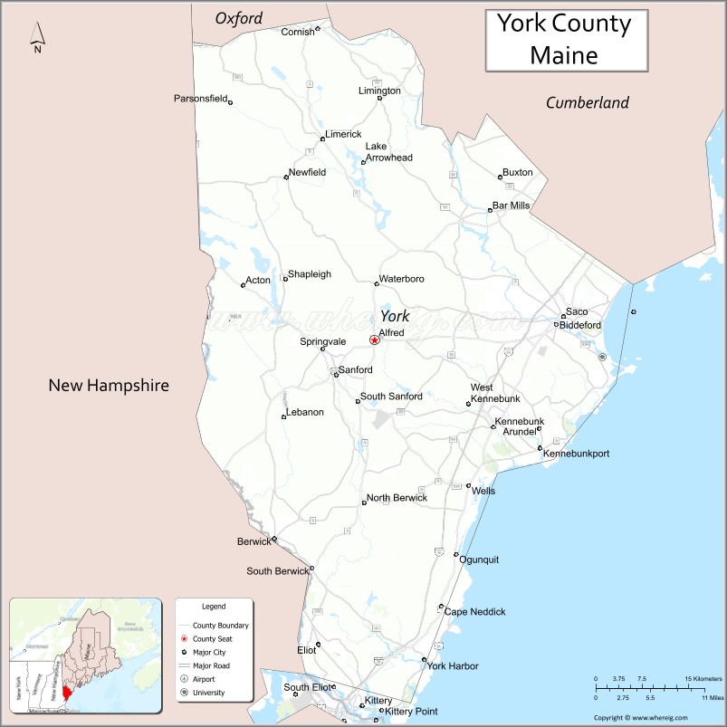
About York County Map, Maine: The map showing the county boundary, county seat, major cities, highways, water bodies and neighbouring counties.
More Maine Maps & Info
| Maine Map | Maine County Map | Map of Maine With Cities |
| Maine Zipcodes | Airports in Maine | Where is Maine |
| Maine Area Codes | Maine Blank Map | Maine River Map |
| US County Map | Maine Physical Map | Maine Road Map |
Map of York County, Maine
York County is a county located in the U.S. state of Maine. It's county seat is Alfred. As per 2020 census, the population of York County is 214591 people and population density is square miles. According to the United States Census Bureau, the county has a total area of 1,271 sq mi (3,292 km2). York County was established on 1652.
York County Facts
| County Info | Facts |
|---|---|
| County | York County |
| County Seat | Alfred |
| State | Maine |
| Country | United States |
| FIPS code | 31 |
| Established | 1652 |
| Area | 1,271 sq mi (3,292 km2) |
| Population | 214591 |
| Density | |
| Formed / Origin | As Yorkshire County, Massachusetts from the southern part of the District of Maine. Renamed York County by Massachusetts in 1668 |
Ctities in York county
| City Name | Type | Population (2020) | Pop. Density | Area | Incorporated |
|---|---|---|---|---|---|
| Biddeford | 22,552 | 30.1 | 1653 sq mi (1855 km2) | 749 | |
| Sanford | 21,982 | 47.8 | 1768 sq mi (2013 km2) | 460 | |
| Westbrook | 20,400 | 38.6 | 1775 sq mi (1867 km2) | 528 | |
| Acton | 2,671 | 38 sq mi | |||
| Alfred | 3,073 | 27 sq mi | |||
| Arundel | 4,264 | 24 sq mi | |||
| Berwick | 7,950 | 37.5 sq mi | |||
| Buxton | 8,376 | 52.2 sq mi | |||
| Cornish | 1,508 | 22.2 sq mi | |||
| Dayton | 2,129 | 17.9 sq mi | |||
| Eliot | 6,717 | 19.8 sq mi | |||
| Hollis | 4,745 | 32 sq mi | |||
| Kennebunk | 11,536 | 35.1 sq mi | |||
| Kennebunkport | 3,629 | 18.6 sq mi | |||
| Kittery | 10,070 | 17.8 sq mi | |||
| Lebanon | 6,469 | 55 sq mi | |||
| Limerick | 3,188 | 27.1 sq mi | |||
| Limington | 3,892 | 41.9 sq mi | |||
| Lyman | 4,525 | 39 sq mi | |||
| Newfield | 1,648 | 32.3 sq mi | |||
| North Berwick | 4,978 | 38 sq mi | |||
| Ogunquit | 1,577 | 4.2 sq mi | |||
| Old Orchard Beach | 8,960 | 7.4 sq mi | |||
| Parsonsfield | 1,791 | 58.9 sq mi | |||
| Shapleigh | 2,649 | 38.8 sq mi | |||
| South Berwick | 7,467 | 32.1 sq mi | |||
| Waterboro | 7,936 | 55.3 sq mi | |||
| Wells | 11,314 | 57.6 sq mi | |||
| York | 13,723 | 54.7 sq mi |
- Androscoggin County Map
- Aroostook County Map
- Cumberland County Map
- Franklin County Map
- Hancock County Map
- Kennebec County Map
- Knox County Map
- Lincoln County Map
- Oxford County Map
- Penobscot County Map
- Piscataquis County Map
- Sagadahoc County Map
- Somerset County Map
- Waldo County Map
- Washington County Map
- York County Map
- Alabama Counties
- Alaska boroughs
- Arizona Counties
- Arkansas Counties
- California County Map
- Colorado Counties
- Connecticut Counties
- Delaware Counties
- Florida County Map
- Georgia County Map
- Hawaii Counties
- Idaho Counties
- Illinois Counties
- Indiana Counties
- Iowa Counties
- Kansas Counties
- Kentucky Counties
- Louisiana Counties
- Maine Counties
- Maryland Counties
- Massachusetts Counties
- Michigan County Map
- Minnesota Counties
- Mississippi Counties
- Missouri Counties
- Montana Counties
- Nebraska Counties
- New Hampshire Counties
- New Jersey Counties
- New Mexico Counties
- North Carolina Counties
- North Dakota Counties
- Oklahoma Counties
- Oregon Counties
- Pennsylvania Counties
- Rhode Island Counties
- South Carolina Counties
- South Dakota Counties
- Map of Tennessee
- Texas County Map
- Utah Counties
- Vermont Counties
- Virginia Counties
- Washington Counties
- West Virginia Counties
- Wisconsin Counties
- Wyoming Counties
- Nevada Counties
- New York Counties
- Ohio County Map