Map of Knox County - Knox County is a county located in the U.S. state of Maine. Knox County Map showing cities, highways, important places and water bodies. Get Where is Knox County located in the map, major cities in Knox county, population, areas, and places of interest.
Map of Knox County, Maine
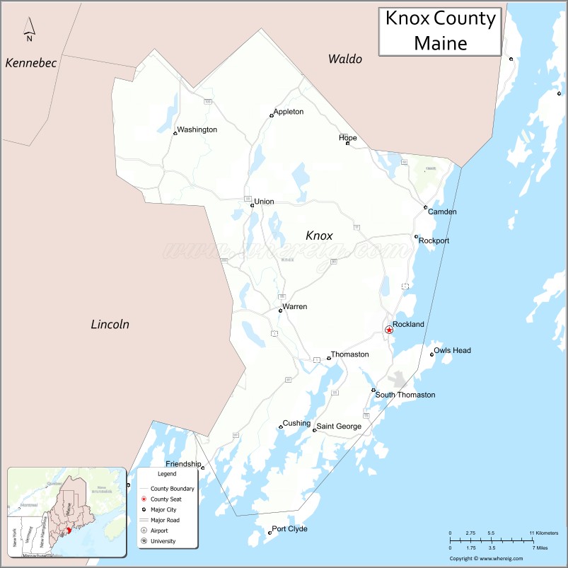
About Knox County Map, Maine: The map showing the county boundary, county seat, major cities, highways, water bodies and neighbouring counties.
More Maine Maps & Info
| Maine Map | Maine County Map | Map of Maine With Cities |
| Maine Zipcodes | Airports in Maine | Where is Maine |
| Maine Area Codes | Maine Blank Map | Maine River Map |
| US County Map | Maine Physical Map | Maine Road Map |
Map of Knox County, Maine
Knox County is a county located in the U.S. state of Maine. It's county seat is Rockland. As per 2020 census, the population of Knox County is 41084 people and population density is square miles. According to the United States Census Bureau, the county has a total area of 1,142 sq mi (2,958 km2). Knox County was established on 1860.
Knox County Facts
| Continent | North America |
| Country | United States |
| State | Maine |
| County Seat | Rockland |
| Largest City/Town | Rockland |
| Established | 1860 |
| Total Area | 1,144 sq mi (2,963 sq km) |
| Land Area | 365 sq mi (945 sq km) |
| Water Area | 779 sq mi (2,018 sq km) |
| Population | 39,607 (Census 2020) |
| Population Density | 108 people per sq mi |
| Time Zone | Eastern Time Zone (ET) |
| Major Highways | U.S. Route 1, Maine State Route 17, Maine State Route 73, Maine State Route 90 |
| Major Rivers | St. George River, Medomak River |
| Neighboring Counties | Lincoln County, Waldo County |
| Famous For | Midcoast Maine scenery, lobster fishing, lighthouses, art museums, sailing |
| Top Attractions | Owls Head Light, Farnsworth Art Museum, Camden Hills State Park, Rockland Breakwater Lighthouse, Maine Lobster Festival |
| Official Website | Official Website |
About Knox County, Maine
Knox County is located along the Midcoast region of Maine in the United States and was established in 1860. Rockland serves as both the county seat and largest city. The county is known for rocky coastlines, lobster fishing, sailing harbors, lighthouses, arts communities, and scenic tourism throughout Midcoast Maine.
Cities and Towns in Knox County, Maine
| City/Town | Population (Census 2020) | Latitude & Longitude |
|---|---|---|
| Rockland (county seat) | 6,936 | 44.1037°N, 69.1089°W |
| Camden | 5,232 | 44.2098°N, 69.0648°W |
| Thomaston | 2,767 | 44.0787°N, 69.1814°W |
| Rockport | 3,644 | 44.1842°N, 69.0764°W |
| Warren | 4,865 | 44.1190°N, 69.2414°W |
| Union | 2,275 | 44.2117°N, 69.2748°W |
| Owls Head | 1,581 | 44.0831°N, 69.0412°W |
| South Thomaston | 1,558 | 44.0479°N, 69.1275°W |
| St. George | 2,609 | 43.9910°N, 69.1873°W |
| Vinalhaven | 1,165 | 44.0481°N, 68.8314°W |
Golf Courses in Knox County, Maine
| Golf Course | Location | Latitude & Longitude |
|---|---|---|
| Goose River Golf Club | Rockport | 44.1912°N, 69.1168°W |
| Samoset Resort Golf Course | Rockport | 44.1353°N, 69.0935°W |
| Rockland Golf Club | Rockland | 44.1061°N, 69.1370°W |
Roads and Highways in Knox County
Major highways connect the county with coastal Maine communities and inland regions.
- U.S. Route 1 - primary coastal highway through Midcoast Maine
- Maine State Route 17 - scenic roadway connecting Rockland with inland lakes and Augusta
- Maine State Route 73 - coastal route through Camden and Rockport
- Maine State Route 90 - connector highway around Rockland and Thomaston
- Maine State Route 131 - regional roadway through St. George Peninsula communities
Neighboring Counties of Knox County
- Lincoln County (southwest)
- Waldo County (north)
Top Attractions in Knox County, Maine
The county offers coastal scenery, art museums, sailing harbors, and famous Midcoast Maine attractions.
- Owls Head Light - historic lighthouse overlooking Penobscot Bay
- Farnsworth Art Museum - renowned museum featuring Maine artists including the Wyeth family
- Camden Hills State Park - mountain hiking trails with ocean and harbor views
- Rockland Breakwater Lighthouse - scenic lighthouse reached by a long granite breakwater
- Maine Lobster Festival - annual seafood festival held in Rockland
- Camden Harbor - sailing, waterfront dining, and scenic boat excursions
- Sailboat and Windjammer Cruises - classic Maine coastal sailing experiences
- Owls Head Transportation Museum - vintage aircraft and automobile exhibits
- Vinalhaven Island - island community known for granite quarries and coastal beauty
- Marshall Point Lighthouse nearby - iconic lighthouse featured in films and coastal photography
Distance from Knox County to Nearby Cities
The following distances are measured by road (driving).
- Rockland to Augusta (Kennebec County), Maine - 52 mi (84 km)
- Rockland to Bangor (Penobscot County), Maine - 78 mi (126 km)
- Rockland to Portland (Cumberland County), Maine - 81 mi (130 km)
- Rockland to Portsmouth (Rockingham County), New Hampshire - 134 mi (216 km)
- Rockland to Manchester (Hillsborough County), New Hampshire - 172 mi (277 km)
- Rockland to Boston (Suffolk County), Massachusetts - 226 mi (364 km)
- Rockland to Burlington (Chittenden County), Vermont - 290 mi (467 km)
- Rockland to Hartford (Hartford County), Connecticut - 336 mi (541 km)
- Rockland to Albany (Albany County), New York - 356 mi (573 km)
- Rockland to New York City (New York County), New York - 429 mi (690 km)
- Rockland to Philadelphia (Philadelphia County), Pennsylvania - 531 mi (855 km)
- Rockland to Washington, D.C. - 634 mi (1,020 km)
FAQs about Knox County
Knox County is located along the Midcoast region of Maine.
Knox County has a population of 39,607 according to the Census 2020.
The county is known for lobster fishing, lighthouses, Midcoast scenery, sailing, and art museums.
Major highways include U.S. Route 1, Maine State Route 17, Maine State Route 73, and Maine State Route 90.
Yes, Knox County has golf facilities including Samoset Resort Golf Course and Goose River Golf Club.
References
- QuickFacts - U.S. Census Bureau
- United States Census Bureau
- United States Geological Survey (USGS)
- Official Website
- State of Maine Official Website
- Androscoggin County Map
- Aroostook County Map
- Cumberland County Map
- Franklin County Map
- Hancock County Map
- Kennebec County Map
- Knox County Map
- Lincoln County Map
- Oxford County Map
- Penobscot County Map
- Piscataquis County Map
- Sagadahoc County Map
- Somerset County Map
- Waldo County Map
- Washington County Map
- York County Map
- Alabama Counties
- Alaska boroughs
- Arizona Counties
- Arkansas Counties
- California County Map
- Colorado Counties
- Connecticut Counties
- Delaware Counties
- Florida County Map
- Georgia County Map
- Hawaii Counties
- Idaho Counties
- Illinois Counties
- Indiana Counties
- Iowa Counties
- Kansas Counties
- Kentucky Counties
- Louisiana Counties
- Maine Counties
- Maryland Counties
- Massachusetts Counties
- Michigan County Map
- Minnesota Counties
- Mississippi Counties
- Missouri Counties
- Montana Counties
- Nebraska Counties
- Nevada Counties
- New York Counties
- New Hampshire Counties
- New Jersey Counties
- New Mexico Counties
- North Carolina Counties
- North Dakota Counties
- Ohio County Map
- Oklahoma Counties
- Oregon Counties
- Pennsylvania Counties
- Rhode Island Counties
- South Carolina Counties
- South Dakota Counties
- Map of Tennessee
- Texas County Map
- Utah Counties
- Vermont Counties
- Virginia Counties
- Washington Counties
- West Virginia Counties
- Wisconsin Counties
- Wyoming Counties