Map of Oxford County - Oxford County is a county located in the U.S. state of Maine. Oxford County Map showing cities, highways, important places and water bodies. Get Where is Oxford County located in the map, major cities in Oxford county, population, areas, and places of interest.
Map of Oxford County, Maine
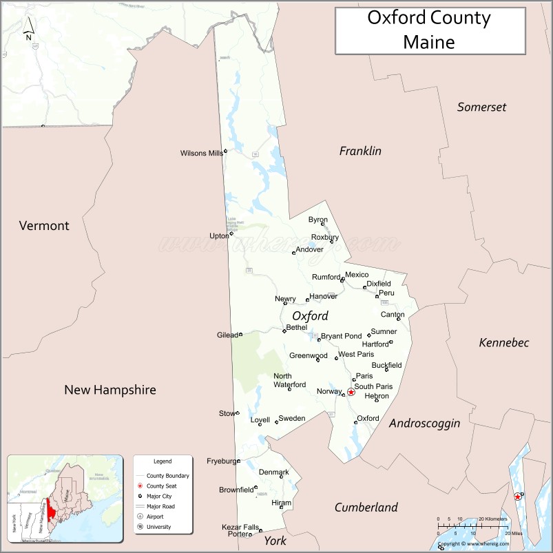
About Oxford County Map, Maine: The map showing the county boundary, county seat, major cities, highways, water bodies and neighbouring counties.
More Maine Maps & Info
| Maine Map | Maine County Map | Map of Maine With Cities |
| Maine Zipcodes | Airports in Maine | Where is Maine |
| Maine Area Codes | Maine Blank Map | Maine River Map |
| US County Map | Maine Physical Map | Maine Road Map |
Map of Oxford County, Maine
Oxford County is a county located in the U.S. state of Maine. It's county seat is Paris. As per 2020 census, the population of Oxford County is 58629 people and population density is square miles. According to the United States Census Bureau, the county has a total area of 2,175 sq mi (5,633 km2). Oxford County was established on 1805.
Oxford County Facts
| Continent | North America |
| Country | United States |
| State | Maine |
| County Seat | Paris |
| Largest City/Town | Oxford |
| Established | 1805 |
| Total Area | 2,176 sq mi (5,636 sq km) |
| Land Area | 2,077 sq mi (5,379 sq km) |
| Water Area | 99 sq mi (257 sq km) |
| Population | 57,777 (Census 2020) |
| Population Density | 28 people per sq mi |
| Time Zone | Eastern Time Zone (ET) |
| Major Highways | U.S. Route 2, U.S. Route 26, Maine State Route 5, Maine State Route 17 |
| Major Rivers | Androscoggin River, Saco River, Little Androscoggin River |
| Neighboring Counties | Androscoggin County, Cumberland County, Franklin County, Somerset County, York County |
| Famous For | Western Maine mountains, ski resorts, lakes, forests, hiking, outdoor recreation |
| Top Attractions | Sunday River Resort, Rangeley Lakes nearby, Grafton Notch State Park, Oxford Casino, Mount Abram |
| Official Website | Official Website |
About Oxford County, Maine
Oxford County is located in western Maine in the United States along the New Hampshire border and was established in 1805. Paris serves as the county seat while Oxford is one of the county’s largest communities. The county is known for mountains, lakes, ski resorts, forests, outdoor recreation, scenic drives, and year-round tourism in western Maine.
Cities and Towns in Oxford County, Maine
| City/Town | Population (Census 2020) | Latitude & Longitude |
|---|---|---|
| Oxford | 4,229 | 44.1284°N, 70.5098°W |
| Paris (county seat) | 5,179 | 44.2598°N, 70.5003°W |
| Rumford | 5,174 | 44.5517°N, 70.5487°W |
| Norway | 5,077 | 44.2140°N, 70.5467°W |
| Mexico | 2,778 | 44.5612°N, 70.5464°W |
| Bethel | 2,504 | 44.4048°N, 70.7909°W |
| Fryeburg | 3,347 | 44.0176°N, 70.9809°W |
| Dixfield | 2,042 | 44.5342°N, 70.4551°W |
| Waterford | 1,486 | 44.1829°N, 70.7103°W |
| Woodstock | 1,357 | 44.3204°N, 70.5404°W |
Golf Courses in Oxford County, Maine
| Golf Course | Location | Latitude & Longitude |
|---|---|---|
| Sunday River Golf Club | Newry | 44.5018°N, 70.8590°W |
| Poland Spring Golf Course | Poland | 44.0531°N, 70.3955°W |
| Lake Kezar Country Club | Lovell | 44.1637°N, 70.8940°W |
Roads and Highways in Oxford County
Major highways connect the county with New Hampshire, mountain regions, and central Maine.
- U.S. Route 2 - major east-west route through western Maine
- U.S. Route 26 - scenic route linking Portland with the mountains and New Hampshire
- Maine State Route 5 - regional highway through lakes and rural communities
- Maine State Route 17 - scenic mountain roadway toward Rangeley and western Maine
- Maine State Route 120 - connector route through Rumford and nearby towns
Neighboring Counties of Oxford County
- Androscoggin County (east)
- Cumberland County (southeast)
- Franklin County (north)
- Somerset County (northeast)
- York County (south)
Top Attractions in Oxford County, Maine
The county offers mountain scenery, ski resorts, lakes, forests, and outdoor recreation throughout the year.
- Sunday River Resort - major ski destination with year-round mountain recreation
- Rangeley Lakes nearby - boating, fishing, snowmobiling, and scenic mountain views
- Grafton Notch State Park - hiking trails, waterfalls, and scenic overlooks
- Oxford Casino - gaming, dining, and entertainment destination
- Mount Abram - skiing, mountain biking, and outdoor recreation
- Bethel Village - charming mountain town with shops and restaurants
- Sabbathday Lake and Kezar Lake - boating, fishing, and swimming recreation
- Appalachian Trail nearby - hiking opportunities through western Maine mountains
- Step Falls Preserve - scenic waterfalls and hiking area
- White Mountain National Forest nearby - camping, hiking, and wildlife viewing
Distance from Oxford County to Nearby Cities
The following distances are measured by road (driving).
- Paris to Portland (Cumberland County), Maine - 50 mi (80 km)
- Paris to Augusta (Kennebec County), Maine - 66 mi (106 km)
- Paris to Bangor (Penobscot County), Maine - 138 mi (222 km)
- Paris to Conway (Carroll County), New Hampshire - 36 mi (58 km)
- Paris to Manchester (Hillsborough County), New Hampshire - 98 mi (158 km)
- Paris to Boston (Suffolk County), Massachusetts - 147 mi (237 km)
- Paris to Burlington (Chittenden County), Vermont - 210 mi (338 km)
- Paris to Hartford (Hartford County), Connecticut - 257 mi (414 km)
- Paris to Albany (Albany County), New York - 272 mi (438 km)
- Paris to New York City (New York County), New York - 349 mi (562 km)
- Paris to Philadelphia (Philadelphia County), Pennsylvania - 451 mi (726 km)
- Paris to Washington, D.C. - 554 mi (892 km)
FAQs about Oxford County
Oxford County is located in western Maine along the New Hampshire border.
Oxford County has a population of 57,777 according to the Census 2020.
The county is known for mountains, ski resorts, lakes, forests, and outdoor recreation.
Major highways include U.S. Route 2, U.S. Route 26, Maine State Route 5, and Maine State Route 17.
Yes, Oxford County has golf facilities including Sunday River Golf Club and Lake Kezar Country Club.
References
- QuickFacts - U.S. Census Bureau
- United States Census Bureau
- United States Geological Survey (USGS)
- Official Website
- State of Maine Official Website
- Androscoggin County Map
- Aroostook County Map
- Cumberland County Map
- Franklin County Map
- Hancock County Map
- Kennebec County Map
- Knox County Map
- Lincoln County Map
- Oxford County Map
- Penobscot County Map
- Piscataquis County Map
- Sagadahoc County Map
- Somerset County Map
- Waldo County Map
- Washington County Map
- York County Map
- Alabama Counties
- Alaska boroughs
- Arizona Counties
- Arkansas Counties
- California County Map
- Colorado Counties
- Connecticut Counties
- Delaware Counties
- Florida County Map
- Georgia County Map
- Hawaii Counties
- Idaho Counties
- Illinois Counties
- Indiana Counties
- Iowa Counties
- Kansas Counties
- Kentucky Counties
- Louisiana Counties
- Maine Counties
- Maryland Counties
- Massachusetts Counties
- Michigan County Map
- Minnesota Counties
- Mississippi Counties
- Missouri Counties
- Montana Counties
- Nebraska Counties
- Nevada Counties
- New York Counties
- New Hampshire Counties
- New Jersey Counties
- New Mexico Counties
- North Carolina Counties
- North Dakota Counties
- Ohio County Map
- Oklahoma Counties
- Oregon Counties
- Pennsylvania Counties
- Rhode Island Counties
- South Carolina Counties
- South Dakota Counties
- Map of Tennessee
- Texas County Map
- Utah Counties
- Vermont Counties
- Virginia Counties
- Washington Counties
- West Virginia Counties
- Wisconsin Counties
- Wyoming Counties