Map of Kennebec County - Kennebec County is a county located in the U.S. state of Maine. Kennebec County Map showing cities, highways, important places and water bodies. Get Where is Kennebec County located in the map, major cities in Kennebec county, population, areas, and places of interest.
Map of Kennebec County, Maine
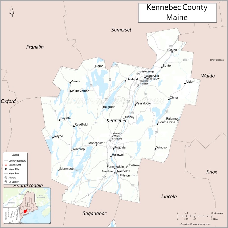
About Kennebec County Map, Maine: The map showing the county boundary, county seat, major cities, highways, water bodies and neighbouring counties.
More Maine Maps & Info
| Maine Map | Maine County Map | Map of Maine With Cities |
| Maine Zipcodes | Airports in Maine | Where is Maine |
| Maine Area Codes | Maine Blank Map | Maine River Map |
| US County Map | Maine Physical Map | Maine Road Map |
Map of Kennebec County, Maine
Kennebec County is a county located in the U.S. state of Maine. It's county seat is Augusta. As per 2020 census, the population of Kennebec County is 124486 people and population density is square miles. According to the United States Census Bureau, the county has a total area of 951 sq mi (2,463 km2). Kennebec County was established on 1799.
Kennebec County Facts
| Continent | North America |
| Country | United States |
| State | Maine |
| County Seat | Augusta |
| Largest City/Town | Augusta |
| Established | 1799 |
| Total Area | 953 sq mi (2,468 sq km) |
| Land Area | 868 sq mi (2,248 sq km) |
| Water Area | 85 sq mi (220 sq km) |
| Population | 123,642 (Census 2020) |
| Population Density | 142 people per sq mi |
| Time Zone | Eastern Time Zone (ET) |
| Major Highways | Interstate 95, U.S. Route 201, U.S. Route 202, Maine State Route 11 |
| Major Rivers | Kennebec River, Sebasticook River, Sandy River |
| Neighboring Counties | Franklin County, Penobscot County, Sagadahoc County, Somerset County, Waldo County |
| Famous For | Maine state capital, Kennebec River, government institutions, lakes, outdoor recreation |
| Top Attractions | Maine State House, Old Fort Western, Belgrade Lakes, Viles Arboretum, Augusta Waterfront |
| Official Website | Official Website |
About Kennebec County, Maine
Kennebec County is located in central Maine in the United States and was established in 1799. Augusta, the state capital of Maine, serves as both the county seat and largest city. The county is known for government institutions, the scenic Kennebec River, historic sites, lakes, outdoor recreation, and central Maine cultural attractions.
Cities and Towns in Kennebec County, Maine
| City/Town | Population (Census 2020) | Latitude & Longitude |
|---|---|---|
| Augusta (county seat) | 18,899 | 44.3106°N, 69.7795°W |
| Waterville | 15,828 | 44.5520°N, 69.6317°W |
| Gardiner | 5,961 | 44.2295°N, 69.7753°W |
| Hallowell | 2,570 | 44.2859°N, 69.7906°W |
| Winthrop | 6,232 | 44.3079°N, 69.9737°W |
| Belgrade | 3,571 | 44.4473°N, 69.8322°W |
| Chelsea | 2,778 | 44.2504°N, 69.7167°W |
| Farmingdale | 3,029 | 44.2448°N, 69.7739°W |
| China | 4,344 | 44.4781°N, 69.5175°W |
| Monmouth | 4,066 | 44.2304°N, 70.0370°W |
Golf Courses in Kennebec County, Maine
| Golf Course | Location | Latitude & Longitude |
|---|---|---|
| Natanis Golf Course | Vassalboro | 44.4493°N, 69.6431°W |
| Augusta Country Club | Manchester | 44.3245°N, 69.8736°W |
| Belgrade Lakes Golf Club | Belgrade Lakes | 44.4826°N, 69.8510°W |
Roads and Highways in Kennebec County
Major highways connect the county with Portland, Bangor, and central Maine communities.
- Interstate 95 - primary north-south interstate through central Maine
- U.S. Route 201 - highway following the Kennebec River corridor
- U.S. Route 202 - regional route linking Augusta with southern Maine
- Maine State Route 11 - roadway through rural and lakeside communities
- Maine State Route 27 - scenic route toward western Maine and mountain regions
Neighboring Counties of Kennebec County
- Franklin County (west)
- Penobscot County (northeast)
- Sagadahoc County (south)
- Somerset County (north)
- Waldo County (east)
Top Attractions in Kennebec County, Maine
The county offers riverfront attractions, government landmarks, lakes, and outdoor recreation.
- Maine State House - historic capitol building in Augusta designed by Charles Bulfinch
- Old Fort Western - oldest surviving wooden fort in New England
- Belgrade Lakes Region - boating, fishing, and lakeside recreation
- Viles Arboretum - walking trails, gardens, and educational programs
- Augusta Waterfront - scenic riverfront parks and walking paths along the Kennebec River
- Colby College Museum of Art nearby - regional art museum and cultural attraction
- Kennebec River Rail Trail - biking and walking trail between Augusta and Gardiner
- Hallowell Historic District - antique shops, restaurants, and riverfront charm
- Messalonskee Lake Recreation Areas - boating and fishing opportunities
- Capitol Park - landscaped grounds surrounding the Maine State House
Distance from Kennebec County to Nearby Cities
The following distances are measured by road (driving).
- Augusta to Portland (Cumberland County), Maine - 57 mi (92 km)
- Augusta to Bangor (Penobscot County), Maine - 76 mi (122 km)
- Augusta to Lewiston (Androscoggin County), Maine - 32 mi (51 km)
- Augusta to Portsmouth (Rockingham County), New Hampshire - 110 mi (177 km)
- Augusta to Manchester (Hillsborough County), New Hampshire - 148 mi (238 km)
- Augusta to Boston (Suffolk County), Massachusetts - 173 mi (278 km)
- Augusta to Burlington (Chittenden County), Vermont - 252 mi (406 km)
- Augusta to Hartford (Hartford County), Connecticut - 283 mi (455 km)
- Augusta to Albany (Albany County), New York - 318 mi (512 km)
- Augusta to New York City (New York County), New York - 376 mi (605 km)
- Augusta to Philadelphia (Philadelphia County), Pennsylvania - 479 mi (771 km)
- Augusta to Washington, D.C. - 581 mi (935 km)
FAQs about Kennebec County
Kennebec County is located in central Maine.
Kennebec County has a population of 123,642 according to the Census 2020.
The county is known for Augusta as the Maine state capital, the Kennebec River, lakes, and outdoor recreation.
Major highways include Interstate 95, U.S. Route 201, U.S. Route 202, and Maine State Route 11.
Yes, Kennebec County has golf facilities including Belgrade Lakes Golf Club and Augusta Country Club.
References
- QuickFacts - U.S. Census Bureau
- United States Census Bureau
- United States Geological Survey (USGS)
- Official Website
- State of Maine Official Website
- Androscoggin County Map
- Aroostook County Map
- Cumberland County Map
- Franklin County Map
- Hancock County Map
- Kennebec County Map
- Knox County Map
- Lincoln County Map
- Oxford County Map
- Penobscot County Map
- Piscataquis County Map
- Sagadahoc County Map
- Somerset County Map
- Waldo County Map
- Washington County Map
- York County Map
- Alabama Counties
- Alaska boroughs
- Arizona Counties
- Arkansas Counties
- California County Map
- Colorado Counties
- Connecticut Counties
- Delaware Counties
- Florida County Map
- Georgia County Map
- Hawaii Counties
- Idaho Counties
- Illinois Counties
- Indiana Counties
- Iowa Counties
- Kansas Counties
- Kentucky Counties
- Louisiana Counties
- Maine Counties
- Maryland Counties
- Massachusetts Counties
- Michigan County Map
- Minnesota Counties
- Mississippi Counties
- Missouri Counties
- Montana Counties
- Nebraska Counties
- Nevada Counties
- New York Counties
- New Hampshire Counties
- New Jersey Counties
- New Mexico Counties
- North Carolina Counties
- North Dakota Counties
- Ohio County Map
- Oklahoma Counties
- Oregon Counties
- Pennsylvania Counties
- Rhode Island Counties
- South Carolina Counties
- South Dakota Counties
- Map of Tennessee
- Texas County Map
- Utah Counties
- Vermont Counties
- Virginia Counties
- Washington Counties
- West Virginia Counties
- Wisconsin Counties
- Wyoming Counties